During the first two weeks of September, and the peak of the Atlantic Hurricane season, NASA satellites were keeping tabs on a number of tropical systems. NASA’s Aqua, Terra, EO-1 and Tropical Rainfall Measuring Mission (TRMM) satellites provided rainfall rates, cloud height, cloud temperature, sea surface temperatures, and extent of cloud cover throughout the life of all the tropical cyclones. NASA/NOAA’s GOES Project also created images and animations from NOAA’s GOES-13 satellite that followed the track of each system through the Atlantic, Caribbean or Gulf of Mexico.
Hurricane Irene lashed the East Coast of the U.S. from South Carolina to the New England states and caused record flooding in Vermont. Tropical Storm Jose lived and died in the Atlantic Ocean, only to give way to Hurricane Katia, which brought rough surf to the U.S. East Coast and did a sling-shot across the Atlantic to bring hurricane-force winds to the U.K. during the second week of September. Nate formed in the Bay of Campeche and after a couple of days made landfall in southeastern Mexico.
Tropical Storm Lee formed south of Louisiana and sat off-shore for days, soaking the northern Gulf coast before making landfall and merging with a frontal system. Lee was then absorbed into a low-pressure area over the Ohio Valley and produced massive rainfall from Florida to Illinois. NASA’s rain gauge in space, TRMM, mapped the massive rainfall generated by Lee.
Day-by-Day
After forming in the north central Gulf of Mexico, Lee came ashore over south central Louisiana on the morning of Sept. 4. That day, an infrared image of Tropical Storm Lee from the Atmospheric Infrared Sounder instrument on NASA’s Aqua satellite measured cloud-top temperatures to tell forecasters where the coldest, highest thunderstorm cloud tops were located. Those cloud-top temperatures were colder than -62 Fahrenheit (-52 Celsius). The strongest rainfall at that time was occurring over coastal Alabama and Mississippi and the Gulf of Mexico.
Over the next two and a half days, the slow-moving storm worked its way across central Louisiana and central Mississippi and into northern Alabama, dumping heavy rains along the way. Tropical Storm Lee joined a frontal system to soak the eastern U.S.
Rainfall estimates from the TRMM-based, near-real time Multi-satellite Precipitation Analysis (TMPA) at the NASA Goddard Space Flight Center in Greenbelt, Maryland, for the period Aug. 31- Sept. 8 for the eastern half of the U.S. showed heavy rains extending inland from the northern Gulf of Mexico across eastern Louisiana, Mississippi, northwestern Alabama, and into central Tennessee. Rainfall totals in this region generally exceed 100 mm (~4 inches), with some parts of Mississippi and Louisiana receiving upwards of 250 mm (~10 inches). Chattanooga, Tennessee broke its all-time, 24-hour rainfall total with 9.69 inches.
TMPA rainfall totals of 125 mm (~5 inches) to as much as 200 to 250 mm (~8 to 10 inches) extended from south central Pennsylvania up into central New York, where the Susquehanna River reached record flood levels in downtown Binghamton. Elsewhere across the mid-Atlantic, rain totals exceeded anywhere from 100 to 150 mm (~4 to 6 inches).
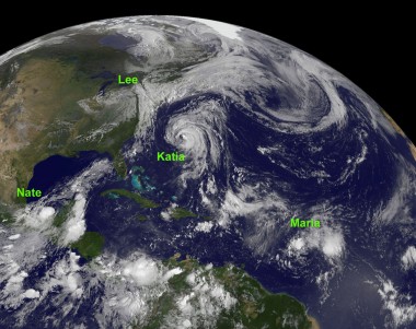
On Sept. 8, NOAA’s GOES-13 satellite captured an image of the cloud cover from Tropical Storm Lee’s remnants that extended from the northern Gulf of Mexico to New England. There also was other activity that satellites were monitoring in the Atlantic, because Katia, Maria and Nate were active and all four systems were captured on one image.
By Sept. 10, another NASA satellite, EO-1, captured a natural-color image of the Susquehanna River, in central Pennsylvania, that was loaded with sediment as a result of Lee’s flooding rainfall.
On Sunday, Sept. 11, at 10 a.m. EDT, the GOES-13 satellite captured Nate’s center as it was just about to make landfall north of Barra de Nautla in the Mexican state of Veracruz, bringing heavy rainfall and sustained winds were near 45 mph. Thirteen hours after making landfall, Tropical Storm Nate weakened into a remnant low-pressure area.
By Sept. 14, Hurricane Katia had made its mark known in the U.K., bringing hurricane-force, heavy rains and rough surf. On the same date, Tropical Storm Maria caused Tropical Storm Warnings for Bermuda, and was expected to follow much the same path as Katia did earlier in the week.