Athina Trakas, Director, European Services, Open Geospatial Consortium (OGC)
(Note: Portions of this paper are excerpted from a longer paper by Mark Reichardt, President & CEO, OGC, titled “Open standards-based geoprocessing Web services support the study and management of hazard and risk,” submitted for publication in the Geomatics, Natural Hazards and Risk Journal.)
Introduction
In recent years, providers of geospatial software and online services – GIS, Earth imaging, navigation, location services, map browsers, etc. – have implemented interfaces and encodings based on a robust framework of open geoprocessing and sensor web enablement standards developed by the OGC. The OGC is an open, consensus-based standards development organization. Products and services implementing these standards are coming into wide use in domains such as ocean observation, defense and intelligence, and civil protection, and they are beginning to be used in many other domains, including emergency and disaster management. Some of the OGC members who are involved with emergency and disaster management are working to advance the use of these standards in applications that also involve new computing models like cloud computing.
This article provides information about the relevant standards used in emergency and disaster management, a list of OGC interoperability initiatives to illustrate the value of open standards in studying and managing natural risks and hazards, and a short introduction to the OGC Emergency and Disaster Management Domain Working Group (E&D DWG).
Cooperation between the geospatial community and the science community is particularly important in studying natural hazards and risks, because observations from multiple disciplines and multiple data collection activities need to be considered together. Arguably, all disciplines that produce and use geospatial data have a need for more data sharing and collaboration. Standardization is a key factor for accessibility of data. It is the definition and adoption of common interfaces and encodings that enables interoperability.
OGC Standards
Twenty-eight member-approved OGC standards are currently available. The summary descriptions of some OGC standards below provide the current scope:
- The OGC® Web Map Service Interface Standard (WMS) provides a simple HTTP interface for requesting geo-registered map images from one or more distributed geospatial databases. A WMS request defines the geographic layer(s) and area of interest to be returned as one or more geo-registered simple map images (JPEG, PNG etc.) that can be displayed in a browser application. The interface also supports the ability to specify whether the returned images should be transparent so that layers from multiple servers can be visually overlaid.
- The OGC® Web Feature Service Interface Standard defines the interface to a data access service that enables features from multiple feature collections (as in a vector GIS) to be queried and managed using HTTP. It additionally defines operations that enable clients to discover feature collections available through the service, access features and their attributes, and enable editing, locking and a range of operations against features and attributes.
- The OGC® Web Coverage Service Interface Standard (WCS) defines a standard interface and operations that enables interoperable access to geospatial "coverages". The term "grid coverages" typically refers to content such as satellite images, digital aerial photos, digital elevation data, and other phenomena represented by values at each measurement point.
- The OGC® Geography Markup Language Encoding Standard (GML) defines a data encoding in XML for geographic data and a grammar to express models of such data. Clients and servers with interfaces that implement the OGC WFS standard read and write GML data. GML is also an ISO standard (ISO 19136:2007). Styling and data schema are clearly separated.
- The OGC® Symbology Encoding Standard (SE) defines an XML language for styling information that can be applied to digital geographic feature and coverage data.
- The OGC® KML Interface Standard, brought into the OGC by Google, is a language for geographic visualization, including annotation of maps and images. Geographic visualization includes not only the presentation of graphical data on the globe, but also the control of the user's navigation in the sense of where to go and where to look. KML is complementary to most of the key existing OGC standards including GML, WFS and WMS.
The full set of OGC standards, including Sensor Web Enablement (SWE) standards described below, along with reference models, standards profiles, public engineering reports, best practices documents, discussion papers and white papers are available at http://www.opengeospatial.org/standards.
A Glossary of Terms is available at http://www.opengeospatial.org/ogc/glossary/.
OGC Sensor Web Enablement (SWE) Standards
Most geospatial data is created by means of sensing and measurement devices (gauges, satellite-borne imaging cameras etc). Most sensors have a location that is pertinent to the sensor’s purpose. For these reasons, OGC members have developed a set of “Sensor Web Enablement” (SWE) standards that provide a Web services framework for working with sensors and sensor data. The following descriptions of some of these standards provides a sense of the scope of this set of free and open resources for the emergency and disaster management community:
- The OGC® Sensor Model Language (SensorML) Encoding Standard defines the general models and XML encodings for sensors. SensorML enables:
- Discovery, processes and plug-and-play operation of sensors. SensorML is the means by which sensors and processes make themselves and their capabilities known, describe inputs, outputs and taskable parameters.
- Observation lineage. SensorML provides history of measurement and processing of observations and supports quality knowledge of observations.
- On-demand processing. SensorML supports on-demand derivation of higher-level information (e.g. geolocation or products) without a priori knowledge of the sensor system.
- Intelligent, autonomous sensor network. SensorML enables the development of taskable, adaptable sensor networks, and enables higher-level problem solving anticipated from the Semantic Web.
- The OGC® Observations and Measurements (O&M) Encoding Standard defines the general models and XML encodings for sensor observations and measurements.
- The OGC® Sensor Observation Service (SOS) Interface Standard provides an open application programming interface (API) for managing deployed sensors and retrieving sensor data and specifically “observation” data.
- The OGC® Sensor Planning Service (SPS) Interface Standard provides an open application programming interface (API) for a service by which a client can determine the feasibility of collecting data from one or more mobile sensors/platforms and submit collection requests to these sensors/platforms.
Examples of projects using OGC standards
Taiwan Debris Flow Warning System
A scenario in the 2008/2009 OGC Web Services 6 (OWS-6) Testbed activity involved an actual implementation of SWE standards in Taiwan and chained Web services in a working debris flow monitoring system. In parts of Taiwan - due to the steep terrain, severe weather (frequent typhoons) and geology (unstable soils and frequent earthquakes) - upland river valleys are subject to sudden and dangerous flows of earth and boulders. Therefore it is important to provide alerts and warnings. This scenario involved alerts, notifications, grid processing and real-time event architecture.
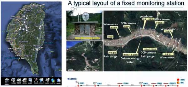
Figure 1. OGC standards have been implemented in a real-time debris flow warning system in Taiwan. (Figure from Geographic Information Systems Research Center at Feng Chia University in Taiwan)
Development and deployment of this system was carried out by researchers and engineers at the GIS Research Center, at Feng Chia University in Taichung, Taiwan and at the Industrial Technology and Research Institute (ITRI). Deployment of an operational Taiwan Debris Flow Monitoring System proceeded throughout 2009, resulting in a working system that supports monitoring of critical conditions. This system provides significantly increased protection for citizens and businesses in thirteen of the river valleys in Taiwan that have the highest potential for debris flows.
At thirteen fixed locations, sensors such as rain gauges, geophones, wire sensors and water level meters provide observation data through ADSL networks or satellite links. Two mobile vehicles equipped with monitoring devices can be dispatched to areas where debris flows are likely.
Web services that implement the OGC Sensor Observation Service (SOS), Sensor Planning Service (SPS) and Sensor Alert Service (SAS) Interface Standards enable communication between the various parts of the system. Components that provide alert notices use the OGC Web Notification Service (WNS). Applications, including one that provides Short Message Service (SMS) alerts, can access stored and real-time data. In some applications, users can click on sensor icons in graphical 3D terrain views to check on the status and outputs of sensors.
The Feng Chia University and ITRI team have provided a comprehensive OGC Best Practices document that serves as a cookbook for implementing SWE, including schemas, examples and working code.
SANY - “Sensors Anywhere”
As a major “Integrated Project” in the Sixth Framework Programme of the European Commission (IST-FP6), SANY extended the interoperability advances of the earlier European project, ORCHESTRA, into the domain of environmental sensor networks and standards-based sensor web enablement to support decision-making.
OGC SWE standards were applied in SANY to three innovative risk management applications involving air pollution, marine risks and geohazards. These efforts yielded valuable reference implementations of sensor web services and geospatial processing Web services for decision support and data fusion.
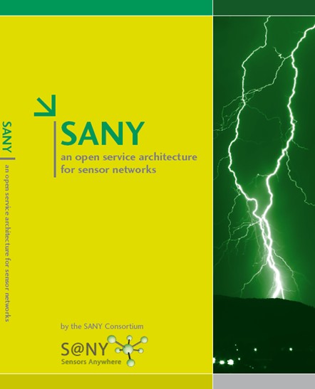
Figure 2: This book summarizes the approaches and results of the SANY project.
Further information and details on the open architecture for sensor networks is available at http://www.sany-ip.eu/publications/3317.
Sensor Webs: The German tsunami warning system for the Indian Ocean
Open source software that implements SWE standards is being used in a number of real-world systems, including a monitoring and control system for the Wupper River watershed in Germany, an Advanced Fire Information System (AFIS), and a wildfire monitoring system in South Africa. Another is the German Indonesian Tsunami Early Warning System (GITEWS), a 35 million Euros project of the German Aerospace Agency (DLR) and the GeoForschungsZentrum Potsdam (GFZ). GITEWS uses SWE services for sharing tsunami related information among GITEWS software components. Real-time sensors and simulation models provide data for GITEWS.
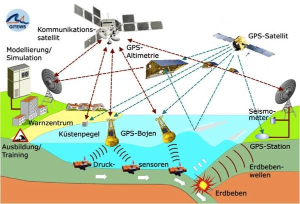
Figure 3: GITEWS provides indicators of a tsunami and its dimensions by the analysis of different measurements at a very early stage.
More detailed information is available at http://www.gitews.org.
The OGC Interoperability Program
http://www.opengeospatial.org/ogc/programs/ip
The OGC, through its Interoperability Program (IP), facilitates testbeds, pilot projects and interoperability experiments in which standards are created and tested. Many of these interoperability initiatives, as shown in the examples below, have had at least a partial focus on hazards and risk, both natural and man-made.
- OWS-6 brought together 10 sponsor organizations and 32 participating organizations to advance standards in five major technology focus areas or “threads”, including: Sensor Web Enablement (SWE), Geo Processing Workflow, Aeronautical Information Management, and Decision Support Services.
- OWS-7 focuses on Sensor Fusion Enablement, Feature and Decision Fusion, and aviation information systems. Fusion is defined as “the act or process of combining two or more pieces of data or information regarding one or more entities to improve the capability for detection, identification or characterization of that entity.” For example, if a power plant has been flooded, advanced fusion capabilities will enable rapid combination of information from many sources for the purposes of assessing the risks inherent in the situation.
- The Geo-interface for Atmosphere, Land, Earth, and Ocean netCDF Interoperability Experiment (GALEON IE) has produced reports that describe how OGC Web services were used in applications that involve netCDF data, a data format used widely in meteorology and climatology. The goal of GALEON IE is to improve interoperability among diverse geospatial information systems used in studying and responding to major storm events, tsunamis and earthquakes.
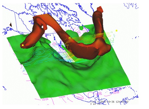
Figure 4: Visualization of Weather Forecast Model Output
- The GEOSS Architecture Implementation Pilot (AIP), a multi-year OGC Interoperability Initiative, brings together technical contributions from over 120 organizations. Their task is to provide the architecture for the Global Earth Observing System of Systems (GEOSS) being developed by the Group on Earth Observations (GEO). The participating governments seek to make a very large collection of geospatial data available on Web servers, including live sensor data and stored geodata of many kinds. The goal is to improve understanding and capacity in dealing with challenges involving disasters, health, energy, climate, water, weather, ecosystems, agriculture and biodiversity.
- OGC is a member of the EO2HEAVEN team that is executing a Collaborative Project of the European Commission Seventh Framework Program (FP7). EO2HEAVEN will contribute to a better understanding of the complex relationships between environmental changes and their impact on human health. The project will monitor changes induced by human activities, with emphasis on atmospheric, river, lake and coastal marine pollution. EO2HEAVEN will specify and implement the Spatial Information Infrastructure (SII) as an open architecture based upon international standards and adaptive geospatial Web services in alignment with the large-scale initiatives INSPIRE (European directive for an Infrastructure for Spatial Information in the European Community) and GMES (the European Earth observation program for Global Monitoring for Environment and Security). The SII will include bridging capabilities at the syntactic and semantic levels to and between environmental and health systems.
Other OGC interoperability initiatives that are directly relevant to emergency and disaster management include: a series of Critical Infrastructure Protection Initiatives, Emergency Mapping Symbology, Fusion Standards Study, Geospatial Fusion Pilot Project, Geospatial Fusion Testbed, Kentucky Watershed Modeling Information Portal, Multihazard Mapping Initiative, Open Location Services Testbed and Sensor Alert Service Interoperability Experiment.
OGC’s Working Groups
The OGC Technical Committee’s 26 domain working groups (DWG) bring together experts from various fields of activity to review and develop standards that meet their domains’ requirements. Domain working groups also sometimes focus on domain-specific data models and schemas that facilitate discovery, access, sharing, analysis, visualization and processing of information among stakeholder organizations. The Technical Committee’s 28 standards working groups (SWG) each have a charter to work on a specific candidate standard prior to approval as an OGC standard or to work on making revisions to an existing OGC standard.
The OGC Emergency and Disaster Management Domain Working Group (EDM DWG) (http://www.opengeospatial.org/projects/groups/edmdwg) provides a forum for uniting communities of users including government agencies, industry, research organizations, Non Governmental Organizations and others whose work involves emergency and disaster management. Like the other Domain Working Groups, the EDM DWG promotes and supports the establishment of requirements, standards and best practices for web service interfaces and encodings.
An example of a standards working group of interest to the EDM community is the Geo Short Messaging Service (GeoSMS) Standard Working Group, which is advancing the OGC Candidate Open GeoSMS Standard as an OGC adopted standard. This candidate standard, currently an OGC Discussion Paper, defines an SMS format to exchange GPS information for different location services devices and applications. The GeoSMS SWG will ensure that the standard is consistent with the OGC baseline, that is, the set of adopted OGC abstract standards, reference models and implementation standards. This is critical, because it will be important in the EDM world for location information from mobile devices and social networking applications to be useable in decision support applications that also involve much more complex types of geospatial data and processing.
The OGC has several committees besides the Technical Committee. A new Business Value Committee has been chartered in the Technical Committee to, as its charter states, “…identify, coordinate and promote the business value of OGC standards and programmes through engaging member senior managers, commercial, sales marketing professionals as well as policy makers and strategic decision makers. The goal is to build a Standard Value Model supported through case studies, reference implementations and business cases for the development and use of geospatial standards in various industry domains and across the community.”
Conclusions
Through open standards – TCP/IP, HTTP, HTML and others – the Internet and the Web connect computers in an extraordinary communications network. The open standards developed by the OGC build on this platform to connect, among other resources, the geospatial software products used in emergency and disaster management. OGC standards have become well established in the marketplace and it is now quite feasible for purchasers of geospatial software to select products whose interfaces and encodings match those of products used by data sharing partners – that is, the products are compliant with the same OGC standards. The standards make it much easier for developers to create interoperable systems, such as sensor webs for early warning, and they make it much easier for decision makers to obtain information from multiple sources at any stage in crisis management. The use of standards considerably reduces investment risks.
Much opportunity remains, however, for information community leaders to contribute requirements into the standards development process and to develop best practices for the communication of geospatial information in their communities. Membership in the OGC helps communities collaborate and exchange knowledge, and it provides opportunities to influence the direction of standards development in important environmental and other arenas.