International support mechanisms and the SpaceAid Framework
International support mechanisms and the SpaceAid Framework natalie.epler Fri, 15 Apr 2011 - 12:09The DLR Center for Satellite based Crisis Information (ZKI): Current status and considerations for the future
The DLR Center for Satellite based Crisis Information (ZKI): Current status and considerations for the future natalie.epler Mon, 18 Apr 2011 - 17:29The International Network of Crisis Mappers
The International Network of Crisis MappersJen Ziemke, Co-Founder, International Network of Crisis Mappers
The Network

The International Network of Crisis Mappers (www.crisismappers.net) is the world’s premier hub for crisis mapping and humanitarian response. The network brings together a diverse set of individuals from the humanitarian, human rights, policy, technology, and scholarly communities, to help catalyze communication and collaboration between and among a wide range of different communities with the purpose of advancing the study and application of crisis mapping worldwide. We are excited by the possibility of continuing our collaboration with UNOOSA/UN-SPIDER on current and future initiatives and were very happy to attend the latest workshop in Bonn.
Throughout the year, the Crisis Mappers Network facilitates continuing virtual interaction among its members. Participants engage the community through monthly webcasts, create and browse profiles, e-mail their needs through our dedicated Google Group, and write blogs and share other announcements with the Group. As of October 2010, the Network had grown to over 1,000 members from over 30 countries across 6 continents. We encourage interested members of the UN-SPIDER community to join the Network. We need your advice and respect your unique expertise in this domain. We are excited by the new innovations that emerge from working together and leveraging our collective knowledge.
We are a volunteer-led, loose horizontal network of engaged individuals committed to working together and learning from one another, and overcoming the problem of informational and institutional silos.
Our value-added
Members of the Crisis Mappers Network revolutionized disaster response in the way they mobilized and collaborated following the earthquake in Haiti in 2010. An excellent overview of the unprecedented role played by the Crisis Mappers Group in Haiti, which helped save hundreds of lives is given in “Measuring our Response: An Executive Summary”, which is available on Google Docs (1). None of this would have been possible without the first International Conference on Crisis Mapping, in Cleveland in October 2009. The conversations that began in 2009 at the conference helped shape a culture of sharing, trust, openness, dialogue, and a commitment among our members that helped enable the remarkable volunteer community response that ensued. Members shared the very latest aerial and satellite imagery, their professional and technical expertise, and countless hours of their time. If someone requested help of our network, within less than an hour typically someone in the community would offer their assistance. Thousands of e-mails, tweets, blog posts, and Skype chats directly helped facilitate humanitarian response on the ground.
This response has certainly not been limited to the crisis in Haiti or just to the Crisis Mappers Network. Several other networks like our friends at Crisis Commons have been integral to this new movement as well. Over the past year, the community broadly defined also proved its continuing capacity to contribute to effective disaster response in the wake of destructive floods, typhoons, conflict, chronic poverty, a cholera epidemic, and after crippling snowstorms and devastating oil spills.
The Crisis Mappers also continue to work on issues related to elections, fraud, and community engagement in repressive regimes. In short, they are brainstorming creative solutions to some of the world’s most complex problems. Please keep in mind these efforts are new and only mark the beginning of what will be a long, evolving process. We need your help identifying and coping with the practical, political, ethical and technical issues that have emerged.
The Conference Series
The International Network of Crisis Mappers convenes an annual conference series, to bring together the most engaged practitioners, scholars, software developers and policy makers at the cutting edge of crisis mapping and humanitarian technology to address and assess the role of crisis mapping and humanitarian technology in disaster response. The inaugural conference took place at John Carroll University in Cleveland Ohio in October 2009. The second annual event was convened at Tufts and Harvard Universities in Boston, Massachusetts in October 2010.
These annual conferences facilitate collective engagement and dialogue that helps construct the boundaries of this emergent new discipline. At the conference, participants also brainstorm how to solve real problems and initiate projects to help advance this new field.
Sections/Discussions
The public portion of the conference begins with an engaging set of five-minute ignite talks, in order to familiarize everyone with the exciting work being done in this space, and in order to maximize value, networking, and interactivity. At ICCM 2010 in Boston, we heard special remarks from the first Chief Information Technology Officer of the UN, Assistant Secretary General Dr. Choi Soon-hong. Our keynote speaker, Kurt Jean Charles, then offered a remarkable first-hand account of what his Haitian technology company did to help save lives after the earthquake. Videos of all ignite and keynote talks from the conferences in 2009 and 2010 are available on the Crisis Mappers homepage (2).
The first day of the public conference also includes an interactive Technology and Analysis Fair that enables participants to directly engage with several different platforms and academic analyses of Crisis Map data. Sessions over the three days are structured to allow ample time for networking and collaboration over breaks and meals.
The invitation-only Annual Meeting kicks off with a series of roundtables meant to explore lessons learned and where to go from here. In 2010, over 20 creative self-organized sessions which were organized and initiated by participants themselves really helped advance and create future directions for this field.
ICCM 2011 builds on highly diverse attendance in 2009 and 2010
Our list of attendees from past conferences span a diverse field, including representatives from: the United Nations Office of the Secretary General, UN Global Pulse, the UN Office for the Coordination of Humanitarian Affairs (OCHA), the UN Development Programme (UNDP) Sudan, UNOOSA/UN-SPIDER, the Operational Satellite Applications Programme of the UN Institute for Training and Research (UNITAR/UNOSAT), the UN Children’s Fund (UNICEF), the UN High Commissioner for Refugees (UNHCR), the World Food Programme (WFP), the UN Foundation, the World Bank, Sustainable Technologies, Accelerated Research - Transformative Innovation for Development and Emergency Support (STAR-TIDES), ICC, EU's Joint Research Center (JRC), NATO, International Committee of the Red Cross (ICRC), American Red Cross, Human Rights Watch, United States Holocaust Memorial Museum (USHMM), Freedom House, US Department of Homeland Security (DHS), US Federal Emergency Management Agency (FEMA), United States Geological Survey (USGS), US Department of State, US Agency for International Development (USAID), American Association for the Advancement of Science (AAAS), National Geospatial Intelligence Agency, Google, ESRI, Amnesty International, Microsoft, Vodafone, IBM, Reuters/AlertNet, International Foundation for Electoral Systems (IFES), New York Times, InterNews, InterAction, Meedan, FortiusOne, GeoCommons, Humanitarian Accoord, iMMAP, Digital Democracy, ImageCat, InSTEDD, Ushahidi , ReliefWeb, Plan West Africa, Sahana, GeoTime, Digital Globe, Mercy Corps, ICT4Peace, Map Kibera, CDAC Haiti, Louisiana Bucket Brigade, NiJeL, FrontlineSMS, OpenGeoSpatial, OpenStreetMap, Solutions.ht, Konpa Group, Development Seed, HealthMap, Tufts, Columbia/SIPA, Tulane, University of Sussex, Carnegie Mellon, Berkeley, National Defense University, UCLA, Stanford, Princeton, Harvard Center for Geographic Analysis, MIT Media Lab, and Crisis Commons.
ICCM 2010 was sponsored by Humanity United, the Open Society Institute, the United States Institute of Peace, the Knight Foundation, Google, ESRI, Ushahidi, the World Bank, the Hitachi Center, the Fletcher School at Tufts University, and GeoTime. The Harvard Humanitarian Initiative and John Carroll University convened the annual conference series in 2009 and 2010.
Our niche
The new field of Crisis Mapping encompasses the collection, dynamic visualization and subsequent analysis of geo-referenced information on contemporary conflicts and human rights violations. A wide range of sources are used to create these crisis maps, such as events data from newspaper and intelligence parsing, satellite imagery, interview and survey data, SMS, etc. Scholars have also developed analytical methodologies to identify patterns in dynamic crisis maps. These range from computational methods and visualization techniques to spatial econometrics and “hot spot” analysis.
While scholars employ these methods in their academic research, operational crisis mapping platforms developed by practitioners are typically devoid of analytical tools. At the same time, scholars often assume that humanitarian practitioners are conversant in quantitative spatial analysis, which is rarely the case. In other words, there is a notable divide between scholars and practitioners in the field of crisis mapping and any division slows the progress of a new field. The purpose of the Network and the conference series is therefore to continue to bridge the divide by bringing scholars and practitioners together to shape the future of crisis mapping.
We hope that the Network and conference series is just the start of many new collaborative ideas that emerge when we work together rather than in isolation from one another. We look forward to many new developments in this space in the months and years to come. We hope you join us!
References
- Measuring our Response: An Executive Summary, on: http://docs.google.com/Doc?docid=0ATKkO3odnjoeZGd2OWpna2NfNTZnY2RiaHhkcQ&hl=en (last viewed 10 November 2010)
- Ignite talks of ICCM 2010, on: http://www.crisismappers.net/video (last viewed 10 November 2010).
Overview of the flood situation in West Africa in 2010: the role of spatial information management
Overview of the flood situation in West Africa in 2010: the role of spatial information managementAbdoulaye Dieye, GIS Officer, United Nations Office for the Coordination of Humanitarian Affairs, Regional Office for West and Central Africa (UNOCHA/ROWCA)
Context
Since 2007, the flood situation in West Africa is becoming more and more recurrent and the impact on the population and infrastructures is becoming more severe.
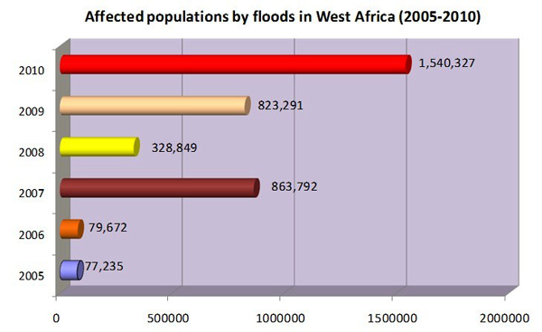
Figure 1: Flood affected populations in West Africa during the last 5 years. Sources: Data from 2005, 2006, 2008: CRED. Data from 2007, 2009, 2010: OCHA.
Since 2009, the United Nations Office for the Coordination of Humanitarian Affairs/Regional Office for West and Central Africa (UNOCHA/ROWCA) has been working closely with the UN Platform for Space-based Information for Disaster Management and Emergency Response of the United Nations Office for Outer Space Affairs (UNOOSA/UN-SPIDER), other UN entities (the World Food Programme (WFP), the Operational Satellite Applications Programme of the UN Institute for Training and Research (UNITAR/UNOSAT), etc.), members of the International Charter Space and Major Disasters (International Charter) for obtaining satellite imagery and rapid mapping, members of the European Services and Applications for Emergency Response (SAFER), governments, and NGOs to support emergency response and risk reduction efforts with geospatial information and rapid mapping.
Flood impact profile in West Africa in 2010
The year 2010 is generally marked by a relative humidity higher than in previous years with heavy rains between June and October over the sub-region of West Africa. Devastating floods are observed in almost all countries of the sub-region with over 1.5 million affected people and over 300 deaths. Significant damages were also noted on socio-economic infrastructures with houses, roads, bridges, hospitals, and schools destroyed, thousands of hectares of farmland and crops washed away, and livestock decimated. Benin is the most affected country with about 690,000 affected people, 86 deaths and 86,000 hectares of farmland damaged. Benin is followed by Nigeria (300,000 Internally Displaced Persons), Niger (226,000 affected people), and Burkina Faso (over 105,000 affected people).
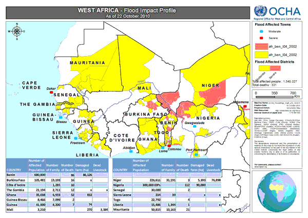
Figure 2: Map of floods impact profile in West Africa
Mechanism of coordination and communication for geo-spatial information and rapid mapping support
Within their respective roles to facilitate the coordination of humanitarian affairs and space affairs, UNOCHA/ROWCA works closely with the UNOOSA/UN-SPIDER to facilitate the activation of mechanisms for spatial information and rapid mapping support (the International Charter, SAFER, etc.) in West Africa.
Mechanism used by UNOCHA to request Charter and SAFER activation in Burkina Faso, Senegal and Benin in 2010
After an alert from the press, local UN Offices, NGOs, or the Government, UNOCHA requests support through the UN-SPIDER SpaceAid Framework and indicates its needs in consultation with UN-SPIDER experts and the UN-SPIDER National Focal Point. UN-SPIDER forwards the request to all partners of the Framework. The project manager who is nominated by the providers (UN-SPIDER partners) works closely with the different stakeholders (UN-SPIDER, UNOCHA, Government). The maps and spatial data are disseminated on the Knowledge Portal and the links are shared to UNOCHA and the National Focal Point as end users. These products are shared to humanitarian partners (UN Offices, NGOs, governments, etc.) to facilitate their activities in the field. A user feedback form is filled in at the end of the support mechanism to evaluate the process.
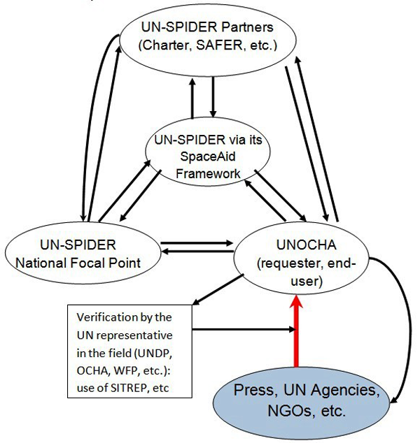
Figure 3: Schematic of the mechanism used to activate SAFER and the International Charter for Burkina Faso, Senegal and Benin.
Examples of spatial information and rapid mapping support in West Africa
In 2009, the International Charter was activated to obtain satellite imagery and support in rapid mapping for Benin, Senegal, Burkina Faso, Niger and Mauritania.
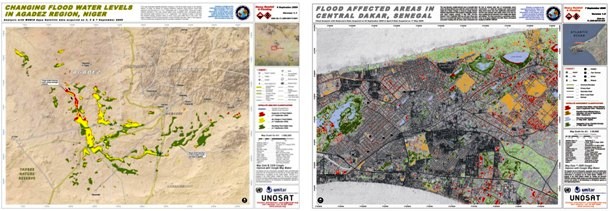
Figure 4: Maps of flooded areas in Agadez (Niger) and Dakar (Senegal) obtained after processing of satellite images from the International Charter.
In 2010, SAFER has been activated for three countries (Burkina Faso, Niger and Senegal), the International Charter for two countries (Benin and Nigeria).
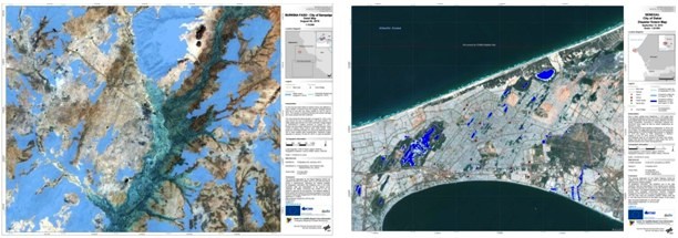
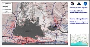
Figure 5: Maps of flooded areas in Sampelga (Burkina Faso) and Dakar (Senegal) obtained after processing of satellite images from SAFER, and Cotonou (Benin) from the International Charter.
These activations were supported by UN-SPIDER as well as by the European Union, the European Space Agency (ESA), the United States Geological Survey (USGS), the German Aerospace Center (DLR) and others. The image processing and rapid mapping were done by UN-SPIDER partner institutions (DLR for SAFER, UNITAR/UNOSAT and the Pacific Disaster Center for the International Charter).
The UN-SPIDER SpaceAid Framework
The UN-SPIDER SpaceAid FrameworkDavid Stevens, Programme Coordinator, United Nations Office for Outer Space Affairs, United Nations Platform for Space-based Information for Disaster Management and Emergency Response (UNOOSA/UN-SPIDER)
When an emergency happens there is an urgent need to assess impacts and requirements as soon as possible. Space-based technologies provide innovative ways to generate information to respond to this need. Earth observation and meteorological satellites continuously image the Earth. If tasked to acquire imagery over disaster areas, these satellite-based sensors can rapidly help evaluate the extent of the impact caused by the disaster, thereby ensuring rescue efforts are sent to the right place. Global Navigation Satellite Systems (GNSS) support response teams by helping them reach the disaster area (navigation) and also by providing the means of registering on a map the location of anything the response team needs to locate geographically (positioning). Finally, satellite communication provides a valuable alternative to land-based communication systems.
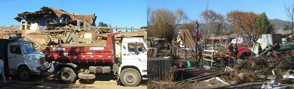
Figure 1 – Impact of the Chile Earthquake 27 February 2010
There are a number of available mechanisms and initiatives that help countries receive relevant information and access space-based technologies to support response efforts, such as the International Charter Space and Major Disasters, Sentinel Asia and Télécoms Sans Frontières. In 2009 the UN-SPIDER Programme initiated the SpaceAid Framework to help countries as well as international and regional organizations benefit from these technologies and this type of information, specifically to:
a) Ensure that all end users are able to access these mechanisms and initiatives, on a 24 hours a day/7 days a week basis, and that they also have the capacity to use all space-based information made available to support emergency events;
b) Provide guidance to the existing mechanisms and initiatives on the specific requirements of the end users and also on how they could improve and extend their support;
c) Establish additional opportunities beyond what is currently available within the existing mechanisms, and;
d) Provide information to those interested in providing support (space-based information and expertise) on how they could channel their support and to whom.
The UN-SPIDER Programme is uniquely positioned to implement and promote this framework:
a) The Programme has been specifically mandated by the United Nations General Assembly to ensure that all countries are able to access space-based information to support emergency response. To this end, since 2007 the Programme has built working relationships with national and regional space agencies, international mechanisms, and technical organizations capable of generating such type of information;
b) The Programme derives strength from a network of UN-SPIDER Regional Support Offices which ensures that end users can access expertise regionally. In its resolution 61/110, the United Nations General Assembly agreed that UN-SPIDER should work closely with regional and national centres of expertise in the use of space technology in disaster management to form a network of Regional Support Offices for implementing the activities of UN-SPIDER in their respective regions in a coordinated manner;
c) Currently, the Office for Outer Space Affairs has signed cooperation agreements with Algeria, Iran (Islamic Republic of), Nigeria, Pakistan, Romania, Ukraine, the Asian Disaster Reduction Center (ADRC), the Regional Center for Mapping of Resources for Development (RCMRD), the Water Center for the Humid Tropics of Latin America and the Caribbean (CATHALAC) and the University of West Indies, formalising the establishment of ten Regional Support Offices worldwide;
d) The Programme has established a network of UN-SPIDER National Focal Points. A National Focal Point is a national institution nominated by the Government of the respective country, representing the disaster management and space application communities. The role of National Focal Points is to work with UN-SPIDER as well as with UN-SPIDER Regional Support Offices to strengthen national disaster management planning and policies and implement specific national activities that incorporate space-based technology solutions in support of disaster management;
e) The UN-SPIDER Knowledge Portal (www.un-spider.org) is central to all activities of the UN-SPIDER Programme as in essence it provides the hosting environment and dissemination tool for all these activities and the resulting outputs and products. Specifically to support SpaceAid, a separate webpage is created for every event and the following information included: information on the event, available value-added products, available pre- and post disaster images, UN-SPIDER contact points, including the Regional Support Office, information on sensor tasking, available geospatial data sets, vector data of impacted areas, and other space-based information and technologies, and;
f) The UN-SPIDER Programme supports countries directly by carrying out Technical Advisory Missions to countries that request such support.
The work of the United Nations Office for Outer Space Affairs in relation to disaster management and emergency response is driven by resolution 61/110 which established the United Nations Platform for Space-based Information for Disaster Management and Emergency Response, known as UN-SPIDER. The accomplishment sought by the programme of work being implemented by UN-SPIDER is greater understanding, acceptance and commitment by countries on ways of accessing and developing capacity to use all types of space-based information to support the full disaster management cycle. UN-SPIDER has been established through this resolution to act as a gateway to space information for disaster management support, to serve as a bridge to connect the disaster management and space communities, and to act as a facilitator of capacity-building and institutional strengthening, in particular for developing countries.
UN-SPIDER staff together with the UN-SPIDER Regional Support Offices is implementing the SpaceAid Framework. The Framework aims at:
a) Ensuring that all end users can access and use all space-based information made available to support emergency events by existing mechanisms and initiatives. Importantly the end users have to be able to access and receive this support on a 24 hours a day/7 days a week basis. The space-based information has to be available to support early warning (monitoring), emergency and humanitarian response as well as early recovery;
b) Providing guidance to existing mechanisms and initiatives on how they could improve and extend their support, as well as establishing new opportunities;
c) Ensuring that providers of space-based information and expertise know who to provide support to.
As depicted in Figure 2, the SpaceAid Framework is built on four cornerstones:
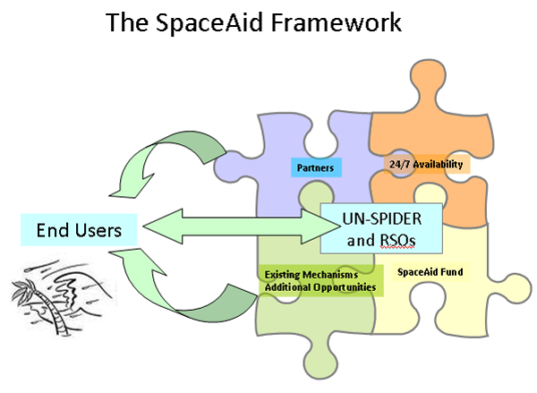
Figure 2 – The SpaceAid Framework
- Existing mechanisms and additional opportunities with which UN-SPIDER establishes cooperation agreements and arrangements to access and make available to end users space-based information and value added products as well as other space-based solutions and technologies;
- An operational 24 hours a day/7 days a week emergency hotline which can be accessed through telephone, e-mail or fax to which end users can send their request for support. Additionally there is the need to ensure that all relevant information is made available immediately to the end users as well as to those interested in providing support;
- Partnerships, in addition to ones established with the UN-SPIDER Regional Support Offices, with leading centres of excellence (national and regional) as well as academic institutions, non-government organisations and private companies willing to provide support to analyse the space-based information and provide scientific and technical expertise to end users, and;
- The SpaceAid Fund which would enable the framework to provide support beyond what is currently possible and also to ensure rapid and direct acquisition of satellite imagery as well as other space-based technologies to support emergency and humanitarian response in cases when existing mechanisms could not provide the full extent of what is required, such as when users need to receive imagery from specific sensors or when there is a need to have multi-agency licenses, as well as for humanitarian response, early recovery and reconstruction.
Existing mechanisms and initiatives
The UN-SPIDER Programme already has in place agreements and arrangements with several of the global and regional initiatives including the International Charter Space and Major Disasters (UNOOSA has been a cooperating body to the Charter since 2003), Sentinel Asia (UNOOSA is a member of the Joint Project Team), and the GMES Project “Services and Applications for Emergency Response” (SAFER). Additionally, UN-SPIDER ensures cooperation with another relevant GMES Project “GMES services for Management of Operations, Situation Awareness and Intelligence for regional Crises” (G-MOSAIC) and works closely in promoting and leveraging upon the opportunities provided by the regional SERVIR projects.
The SERVIR Regional Visualization and Monitoring System integrates Earth observations and forecast models together with in situ data and knowledge for timely decision-making to benefit society, particularly to support disaster management. SERVIR is being implemented regionally in Latin America and the Caribbean by CATHALAC, in Eastern Africa by RCMRD, and in the Himalaya region by the International Centre for Integrated Mountain Development (ICIMOD) in Nepal. Both RCMRD and CATHALAC are UN-SPIDER Regional Support Offices, which ensures close coordination and strengthens the regional work.
The UN-SPIDER Programme works closely with the above projects and initiatives, promoting them with end users and ensuring that these end users establish direct working relationships with such mechanisms. Additionally, the UN-SPIDER Programme provides guidance to these projects on how they could improve and extend their support to meet the need of the end users.
Building additional opportunities and partnerships
In providing support to countries the UN-SPIDER Programme takes advantage of additional opportunities governments, non-governmental organisations and the private sector are making available and also ensures the involvement of leading centres of excellence to support the analysis of the space-based data being made available.
China has offered direct access to its satellites HJ-1A and HJ-1B and has already provided imagery to support several emergencies. Additionally, the UN-SPIDER Programme has worked closely with several providers of space-based imagery including NASA, DLR, RapidEye, Scanex, Digital Globe and GeoEye, facilitating the access of data made freely available by these providers to the end users.
In providing support to countries the UN-SPIDER Programme aims at involving the UN-SPIDER Regional Support Offices and other centres of excellence that are in a position to support the analysis of the data and in the production of the maps and value-added products.

Figure 3 – UN-SPIDER Regional Support Offices – 1st Meeting 09 February 2010
Support provided in 2009 and 2010
In 2009 the SpaceAid Framework supported a total of 20 events globally (Afghanistan, Bangladesh, Burkina Faso, El Salvador, Fiji, Guatemala, Indonesia, Iran (Islamic Republic of), Italy, Lao PDR, Morocco, Namibia, the Philippines, Samoa, Senegal, Tajikistan and Vietnam). In the first 10 months of 2010 a total of 25 emergency events have already been supported including the two devastating earthquakes that hit Haiti and Chile (Benin, Burkina Faso, Chile, China, Cook Islands, Gaza oPt, Guatemala, Haiti, Kazakhstan, Kenya, Madagascar, Moldova, Pakistan, Senegal, Solomon Islands, Sri Lanka, Sudan, Tajikistan, Tonga, Turkey, Uganda and Ukraine).
The evident increase in the number of events supported by the SpaceAid Framework is due to the implementation of standard operating procedures which contributed to the streamlining and optimisation of the support provided, the establishment of additional agreements and arrangements with existing mechanisms and opportunities, and the increasing expansion of the network of UN-SPIDER Regional Support Offices which brings in additional expertise and resources.
In order to be able to receive funds that will support the functioning of the SpaceAid Framework, particularly to ensure rapid and direct acquisition of satellite imagery as well as other space-based technologies to support emergency and humanitarian response in cases when existing mechanisms could not provide the full extent of what is needed, the Office for Outer Space Affairs set up a specific account within the existing “Trust Fund in Support of United Nations Space Applications Programme”. This fund will complement the existing opportunities, ensuring that all countries in the world are able to request and receive space-based information to support all emergency and humanitarian response activities.