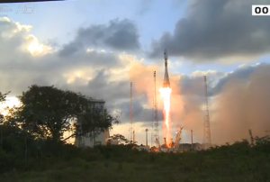
Europe

country taxonomy block

The first documents for Europe’s MetOp Second Generation (MetOp SG) weather satellite mission were signed on 20 May 2014 by representatives from ESA and Airbus Defence and Space at the Berlin Air Show.

MetOp SG will comprise three pairs of satellites and will be launches starting 2021. They will follow a first generation of MetOp satellites: The first MetOp satellite, MetOp-A, was launched in 2006, followed by MetOp-B in 2012. MetOp-C will be added in 2018 to guarantee the continuous delivery of readings for medium- and long-term weather forecasting and for climate monitoring until the launch of the MetOp-SG satellites.

ESA explains on their website: "As with the first generation, MetOp-SG will deliver crucial information on atmospheric temperature and water profiles, cloud detection and analysis, and sea-surface temperature and winds, extending to trace gases and air quality." MetOp-SG is a collaborative project between ESA and the European Organisation for…

more
Publishing date 21/05/2014

The Copernicus Emergency Management Service (EMS) is celebrating its two year anniversary after becoming fully operational in April 2012. Since its activation two years ago EMS has provided timely and accurate geospatial information for the management of disasters caused by natural hazards, man-made emergency situations and humanitarian crises. During its first two years EMS was activated 69 times in rush mode and 7 times in non rush mode and provided 810 maps to users and flood warnings via the early warning component of the EMS most notably during the Central European floods in June 2013 that affected Germany, Austria, Hungary, the Czech Republic and Slovakia. Copernicus EMS also responds to activation from developing countries around the world in need of assistance in Disaster Management 

The Copernicus Emergency Management Service has been activated eight separate times during 2014 alone responding to floods in the UK, France, Slovenia and Croatia. Imaging has also…

more
Publishing date 15/04/2014

ESA has successfully launched the first satellite for the Copernicus program – Sentinel 1. The 2.3 tonne satellite lifted off on a Soyuz rocket from Europe’s Spaceport in Kourou, French Guiana at 21:02 GMT.

The Sentinel 1 Synthetic Aperture Radar (SAR) instrument will scan the Earth’s surface in all weather conditions day and night. It will be used mainly for environmental monitoring in Europe, Canada and the polar regions. The maritime monitoring applications include ice and ship monitoring, as well as support for oil pollution detection and tracking. The satellite sensors will also be able to determine the direction, length and height of waves.  In monitoring the land surface of the planet the satellite will be used to support forest management and deforestation monitoring. Satellite data and images will also be used to create agricultural maps to monitor production and productivity. This feature is especially important for efforts in areas with food security problems…

more
Publishing date 04/04/2014

On 12 March 2014, the European Parliament adopted the Regulation of Copernicus, the European Union's Earth Observation Programme. With the adoption of the regulation, the Copernicus programme is entering the operational phase after years of preparation. The next step is the launch of the first Copernicus satellite, Sentinel-1, beginning of April from Europe’s Spaceport in French Guyana. In a press release the European Commission stated: "Indeed, the adoption of the Regulation paves the way for the continuous development of the programme. This text, which still needs to be adopted by the Council, defines Copernicus objectives, governance and funding (some € 4.3 billion euros) for the period 2014-2020."

European Commission Vice President Antonio Tajani, responsible for industry and entrepreneurship said:…

more
Publishing date 13/03/2014

The French government has announced to release free of charge satellite images from its Spot optical Earth Observation data archive as part of the country’s contribution to the Global Earth Observation system of Systems (GEOSS).

The French Space Agency CNES made this decision with the approval of Airbus Defense and Space which commercializes Spot data. CNES has already begun processing a first tranche of 100.000 images and will make them available later this year. The released images will be at least fives years old and with resolutions not higher than 10 meters.

“We had a long debate with our colleagues at Airbus, and this is the result we came to,” Steven Hosford, Head of the Earth Observation data access plan at CNES explains. “It meets our objective of making the data available for global change studies, while acknowledging the interest we all have in the sustainability of a [commercial] Earth observation sector.”

Without the free…

more
Publishing date 06/03/2014

ESA is moving ahead with the development of their next-generation satellite communication platform - NeosatThe Phase-B contract was signed on 20 February in Paris, France. ESA contracted the European firms Airbus Defense and Space and Thales Alenia Space to build the new generation Neosat spacecrafts. 

Magali Vaissiere, ESA's Director of Telecommunications and Integrated Applications, highlighted the importance of the project for the European market: “Neosat will foster the competitiveness of European satellite industry and strengthen Europe’s position in the core satcom market for the next decade. This is a unique opportunity for Europe’s suppliers, as 80% of European satellite platform equipment is…

more
Publishing date 21/02/2014

NASA satellite data shows the recent weather divergences on Earth - particularly in North America and Europe. At the beginning of 2014 the temperatures in the northern hemisphere showed how the atmosphere can produce two contrasting weather extremes at the same time. While in northern America the temperatures fell way below zero, most of Europe enjoyed temperatures of +10 degrees Celsius.

What connects both events are giant meanders in high-altitude winds known as Rossby waves. These planetary-scale waves define the jet stream and do much to determine the type of weather any given area will face over periods of days to weeks. However, the waves are also governed by fundamental laws of fluid dynamics and thermodynamics that ensure the total amount of energy circulating through the global atmosphere does not change, despite the weather extremes in one area or another.

The data acquired by the Moderate Resolution Imaging Spectroradiometer (MODIS) on NASA’s satellite Terra…

more
Publishing date 13/01/2014

What happens with satellites when they finish their mission? Staying in orbit may pose a threat to other spacecraft, so now scientists are testing safe ways to deorbit ageing satellites.

Future satellites might carry a “gossamer sail” – a device which will open when the spacecraft has to leave orbit. The increased aerodynamic drag will pull the satellite out of orbit to burn up in the high atmosphere. This technique will reduce the risks for the environment.

At launch the Sail is extremely compact – 2 kg and will be able to bring down a satellite weighing up to 700 kg. The Sail was developed at the University of Surrey’s Space Centre, funded through ESA’s Advanced Research in Telecommunications Systems program. The technology will be foremost used for low orbit satellites, flying lower than 700 km up – mostly providing low-speed data communications and messaging services.

In 2008 ESA signed the European Code of Conduct for Space Debris Mitigation and committed to…

more
Publishing date 08/01/2014

On 10 December 2013, the European Parliament adopted new legislation on the EU Civil Protection Mechanism paving, by doing so, the way for stronger cooperation in responding to disasters. The revised legislation on the EU Civil Protection Mechanism contains new actions to be undertaken in relation to disaster risk reduction and the scope of building a culture of prevention, promoting better preparedness and planning, closer cooperation on disaster prevention and more coordinated and faster response.

"The revised legislative proposal includes measures that will help us prepare better for the upcoming disasters. Successful disaster management is first and foremost about providing security to our citizens", said Kristalina Georgieva, the EU Commissioner for International Cooperation, Humanitarian Aid and Crisis Response.

For these purposes, Member States have agreed to share a summary of their risk assessments and best practices, as well as to help each other identify gaps…

more
Publishing date 13/12/2013

From 12-13 November 2013, the Global Disaster Alert and Coordination System (GDACS), a cooperation framework under the UN umbrella, met in Brussels to draw up benchmarks that regional crisis centres can use to improve coordination. There are eight regional crisis centres in the world and also two global crisis centres run by the UN, which compile, analyse and share information in the early days of a disaster, sending out alerts and providing needs to aid humanitarian responders and maps of affected areas. However, it is crucial to improve coordination among the centres.

According to officials from the ERCC, global crises and disaster management lacks formal set of rules that regulates the procedures and standards of interaction between national and international authorities during crises. “There are no formal international procedures or standards to ensure how crisis centres would interact in a crisis” Thomas Peter, manager of the ERCC and the GDACS secretariat says, “…

more
Publishing date 03/12/2013

UN-SPIDER's Regional Support Office in Romania, hosted by the Romanian Space Agency (ROSA), is currently implementing an updated version of the National Emergency Service in the framework of the "Platform for Geoinformation in Support of Disaster Management (GEODIM)" project. The service provides value-added products for all the phases of a disaster, namely preparedness/prevention, emergency response, and recovery. GEODIM gathers all the puzzle pieces consisting in services provided by the International Charter "Space and Major Disasters", Copernicus – Emergency Management Service (EMS), and UN-SPIDER under a unique Romanian emergency response downstream service.

The GEODIM project (July 2012 – June 2015) is funded by the Executive Agency for Higher Education, Research, Development and Innovation Funding under the authority of the Romanian Ministry of Education, Research, Youth and Sport. The project partnership includes the National…

more
Publishing date 02/12/2013
Regional Support Offices mentioned:

Wildfires remain a serious problem, presenting often-dramatic impacts that can only be minimized through a smart combination of technology, political decision and willingness to accept changes.

Since 1970s satellite remote sensing of fires has become increasingly important, developing various sensors that have been used successfully to detect active fires. In that context, MODIS (Moderate Resolution Imaging Spectroradiometer) is probably the most prominent sensor. Furthermore, nighttime imagery from DMSP-OLS and data from AVHRR (Advanced Very High Resolution Radiometer) have been applied for fire identification. As for prevention efforts, satellite-derived soil moisture information has been used in the context of fire research in an attempt to identify increased pre-event vulnerabilities.

In addition, the International Charter Space and Major Disasters aims to provide a system of space data acquisition and delivery to countries and regions affected by any natural…

more
Publishing date 22/11/2013

With the entering into force of the European Delegated Act on Copernicus data and information policy in the coming days, users will be provided free, full and open access of environmental data from the Copernicus programme, including data from the Sentinel satellites. “The free and open Sentinel data policy will be a breakthrough in the use of satellite data for specialised users, but also for the general public,” said Josef Aschbacher, Head of the ESA Copernicus Space Office.

The first of the Sentinel series of satellites is set for launch next year as part of the European Programme for the establishment of a European capacity for Earth Observation, called Copernicus. It is expected that Copernicus could generate a financial benefit of some €30 billion and a minimum of about 50,000 new jobs by 2030 as well as crucial information to improve the management of the environment, help to understand and mitigate the effects of climate change and ensure civil security.

Publishing date 21/11/2013

In November 2013 Germanwatch published the 9th edition of the Global Climate Risk Index for which the most recent data available —from 1993 to 2012— were taken into account. The Global Climate Risk Index 2014 analyses to what extent the impacts of weather-related loss events have affected countries around the globe.

This year's edition of the Climate Risk Index reconfirms that less developed countries are generally more affected than industrialised countries. In the year of 2012 Haiti, the Philippines and Pakistan were the most affected countries, while for the period that goes from 1993 to 2012 Honduras, Myanmar and Haiti rank highest.Furthermore, weather-related loss events are called to become more frequent or more severe due to climate change, further increasing current vulnerability in some regions.

Concerned about climate change and the increasing loss and damage, the climate summit 2013 held in Warsaw, Poland, is a defining moment and should mark a turning point…

more
Publishing date 12/11/2013

The European Earth Observation Services Industry is steadily growing. This is the main outcome of the report "A Survey into the State and Health of the European EO Services Industry"- The report was prepared and published under assignment from the European Space Agency (ESA) by the EARSC (European Association of Remote Sensing Companies) and it covered all companies fo whom satellite derived EO data is part of their business.

The report states: "There has been a steady growth in the turnover of the sector since the previous survey in 2006 accompanied by a good growth of employment. The sector has seen a lot of change. The period has seen the launch of a number of new commercial satellite systems (see section 2) as well as significant technology change with the development of Google Earth, the advent of cloud computing and a move towards crowd sourcing. These and other technologies such as Remotely Piloted Aircraft systems are arriving on the horizon and maybe…

more
Publishing date 23/09/2013

The International Space Station (ISS) partner agencies released a common statement on 17 July 2013 underlining the benefits of the space station during disasters caused by natural hazards on Earth. The ISS partner agencies US National Aeronautics and Space Administration, Canadian Space Agency, European Space Agency, Russian Federal Space Agency and Japan Aerospace Exploration Agency stated "The ISS Partners are committed to continuing to share this unique asset in space and the benefits it brings to life on Earth."

The International Space Station (ISS) is a global research facility primary focused on Earth observation. "A unique complement of automated and crew-operated Earth observation assets are on board the ISS" the statement informs, "in addition, the orbit of the ISS provides a distinct perspective over Earth targets that augments polar-orbiting remote sensing spacecraft". Consequently, it is easy to imagine the…

more
Publishing date 22/07/2013

Massive floods have heavily affected regions in Germany, Austria, Czech Republic and other European countries over the past days taking at least five human lives and causing damages of a yet undetermined extent. In order to better prepare for such floods in the future, satellites such as ESA's SMOS could help to improve the accuracy of flood prediction by measuring the soil moisture. Prior to the torrential rains, SMOS showed that soils in Germany were showing record levels of moisture – in fact, the highest ever observed. The picture shows the wet soils in blues and the dryer soils in yellows.

ESA's Soil Moisture and Ocean Salinity (SMOS) mission monitors the amount of water held in the surface layers of the soil and the concentration of salt in the top layer of seawater. This information is helping scientists understand more about how water is cycled between the oceans, atmosphere and land – Earth’s water cycle. It is also helping to improve weather forecasts.

ESA…

more
Publishing date 07/06/2013

The European satellite navigation mission Galileo marked a new success: On 25 April 2013, all four Galileo satellites started working as clocks accurate to a few billionths of a second, disseminating the exact time through their signals expressed as the UTC Universal Coordinated Time global standard.

“A billionth of a second equals a nanosecond, a time interval far beyond our own human capacity of appreciation,” explains Marco Falcone, ESA’s Galileo System Manager.

ESA explains the necessity of Galileo to work as precise clocks: "Galileo, like all other satellite navigation systems, is based on the highly precise measurement of time. A receiver on the ground pinpoints its position by calculating how long signals from satellites in orbit take to reach it. Matching the receiver and satellite clocks then multiplying the time taken by the speed of light gives the range between user and satellite, allowing the receiver to fix its own location relative to four or more…

more
Publishing date 02/05/2013

On 9 April 2013, Eumetsat's Meteosat-9 satellite took over the rapid scanning imagery service (RSS) from Meteosat-8.

After being replaced in January by Meteosat-10 as the prime operational satellite supplying full disk images of Europe and Africa, Meteosat-9 now provides the RSS, delivering more frequent images every five minutes over Europe only. The two-satellite system continues the services previously delivered by Meteosat-8 and -9 in support of weather forecasters in one of their most challenging tasks, nowcasting, which involves detecting and monitoring rapidly developing high impact weather like thunderstorms or fog and issuing related warnings up to 12 hours ahead.

The Meteosat satellites are operated by Eumetsat, an intergovernmental organisation based in Darmstadt, Germany, currently with 26 European Member States. It operates Meteosat-8, -9 and -10 over Europe and Africa, and Meteosat-7 over the Indian Ocean.

Publishing date 10/04/2013

In a recent press release the European Commission announced that Europe and Japan are forging a closer cooperation in disaster management. Kristalina Georgieva, the European Commissioner for International Cooperation, Humanitarian Aid and Crisis Response and Akihiro Ohta, Minister of Land, Infrastructure, Transport and Tourism of Japan have exchanged letters providing a framework to further enhance EU-Japan cooperation in disaster management.

"Natural Disasters are becoming more intense and more frequent. This makes us all vulnerable. The triple disaster that hit Japan in March 2011 showed that even the best prepared countries can be overwhelmed by the force of nature. We can better meet these challenges by working together. I am convinced that exchanging information and best practices will benefit us both, the EU and Japan," said Commissioner Kristalina Georgieva.

The letters provide the basis for cooperation in a broad spectrum of disaster risk reduction topics,…

more
Publishing date 28/03/2013

In a recent press release, the European Commission announced that on 12 March 2013 for the first time ever, engineers have been able to determine a position relying only on the signals emitted from four satellites of the European satellite navigation system Galileo.

This achievement is a milestone towards offering initial satellite navigation services from 2014 onwards. Once fully deployed, Galileo will enable a wide range of new applications, including innovative personal services such as in-car navigation, high precision farming, transportation, emergency intervention and civil protection, with a signal enabling higher precision previously available.

European Commission Vice President Antonio Tajani, Commissioner for Industry and Entrepreneurship, said: “I am thrilled by this successful test and I want to congratulate the…

more
Publishing date 19/03/2013

For its newest geostationary Earth Observation satellite, GO-3G, the European aerospace company Astrium is seeking for a non-European partner, as SatelliteToday reported.

According to reports, Astrium is reaching out to countries outside of Europe to help finance this venture. The company has indicated that Singapore could be one of the possible countries interested in the GO-3S. To entice possible partners, Astrium is offering dedicated capacity and share of revenue from services derived from the satellite.

The GO-3S will cover approximately one quarter of the Earth’s surface with a 3-meter resolution and a picture rate of five images per second. According to Astrium, the satellite could potentially be capable of directing its field of observation to a target zone in just a few minutes to transmit images and video to the ground in real time. The satellite will feature a mirror about 4 meters in size that can observe 60 x 60 miles areas. Additionally the GO-3S,…

more
Publishing date 28/02/2013

The 4th Global Platform for Disaster Risk Reduction will be held in Geneva, Switzerland, from 19 to 23 May at the International Conference Centre of Geneva (CICG). Heads of State, government ministers, parliamentarians, CEOs, scientists and civil society representatives will meet to discuss a new global framework to reduce disaster risk.

It is expected that around 3,000 people will attend this fourth session of the Global Platform which will be the last to take place before the World Conference on Disaster Risk Reduction in Japan in 2015. The United Nations Office for Disaster Risk Reduction, UNISDR, estimates that since the year 2000, earthquakes, floods, storms, tsunamis, heat waves and other disaster events have killed 1.1 million people, disrupted the lives of 2.7 billion and caused over $1.3 trillion in economic losses.

UNISDR Chief Margareta Wahlström, who is also the UN Special Representative for Disaster Risk Reduction, said: "This will be the last Global…

more
Publishing date 06/02/2013

New technologies have sometimes had very harmful effects, but in many cases the early warning signs have been suppressed or ignored. The second volume of Late Lessons from Early Warnings published by the European Environment Agency (EEA) investigates specific cases where danger signals have gone unheeded, in some cases leading to deaths, illness and environmental destruction.

The first volume of Late Lessons, published in 2001, was a ground breaking report detailing the history of technologies subsequently found to be harmful. The new 750-page volume includes 20 new case studies, with far-reaching implications for policy, science and society.

The report outlines the following key recommendations:

  • Key recommendations Science should acknowledge the complexity of biological and environmental systems, particularly where there may be multiple causes of many different effects, the report says. It is increasingly difficult to isolate a single agent and…
more
Publishing date 24/01/2013

In the context of the heavy rains and floods that affected the UK lately, the need for methods how to more accurately predict heavy rainfall over land surface has become evident. Existing computer models used in the UK cannot show exactly where the rain will accumulate and cause problems.

Professor Paul Bates from the University of Bristol has been working on this problem for much of the last decade. He and his colleague, Dr Ad de Roo from the EU Joint Research Centre in Italy, decided to rethink the physics behind the complex and expensive computer models. "Instead of loading more and more physical processes into the prediction model we decided to turn it on its head and find a simpler way," says Bates. The pair worked out the minimum amount of physics needed to improve the model's predictive skill over a large area and at high resolution.

Bates and de Roo developed a new two-dimensional flood inundation programme which they have improved over the years, creating a…

more
Publishing date 05/12/2012