![]()
United
Nations
Earthquake
 Earth Observation Center (EOC) using data acquired by Sentinel-1A before and after the earthquake event. Image: DLR/EOC")
Definition
Facts and figures
Further information
UN-SPIDER Regional Support Offices with hazard-specific expertise
Related content on the Knowledge Portal
 Derived products from various satellites processed by agencies in the field of disaster mapping.Publishing institution:
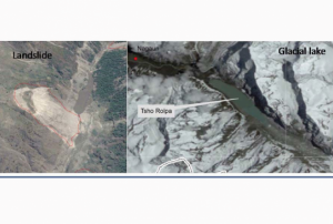 ,
, 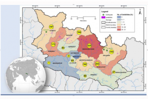
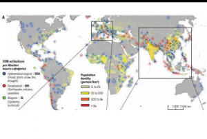
Close to 2000 landslides were mapped using a high-resolution image of the post 2015 Nepal Earthquake made available through International Charter for Space and Major Disaster, and Sentinel Asia. The images were geo-referenced if not done prior to visual scanning for a fresh scar from landslide and rockslide. Cross-checking with pre-event images most of which are available on Google Earth helped confirm whether or not the event is related to the earthquake. There are many large glacial lakes in and around the earthquake affected region, which was regularly monitored using multi-temporal high-resolution satellite data to pick up signs of potential failure. Mapping of landslide and monitoring of glacial lake using earth-observation data provided much needed situational awareness on the geo-hazard situation.
read morePublishing institution: After the TAM was conducted in Myanmar, innovative impacts were completed following a recommendation. “Emergency Operation Centre (EOC)”, which is comprised of four units including “Remote Sensing Unit” and “Risk Assessment and Emergency Response Unit” was established in the Ministry of Social Welfare, Relief & Resettlement (MSWRR). The capacity building of MSWRR and other related institutes in remote sensing and GIS were strengthened. The Disaster Management Training Centre now conducts courses in remote sensing/GIS. Myanmar has also become the first country in ASEAN to apply for universal access to the International Charter. Myanmar government is aware of the National Spatial Data Infrastructure (NSDI) and one map policy that has been initiated by the Ministry of Education is very crucial.read morePublishing institution:
 ,
, 
In order to encourage the targeted retrieval of space-based information and data by disaster risk reduction practitioners, content on the Portal is systematically enriched with metadata. For instance, data sources are marked up with data about their file type, satellite/sensor and spatial coverage and whether they relate to the disaster risk management or emergency response phase. The tool features a range of filters that draw on the metadata, thereby allowing users to narrow down their search, for example, filtering available GIS software by hazard type. This ensures that users efficiently find the content that is most relevant to them. At the same time, the Portal encourages the discovery of resources related to those accessed by the user, by providing links to them on the same page. This allows for contextualisation and highlights links between resources…
read morePublishing institution: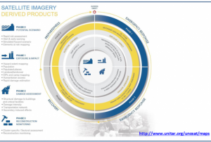 ,
, 
Based on optical and radar images of different resolutions, UNOSAT products are also enriched with the available baseline GIS datasets and crowdsourcing data. Satellite-derived analysis performed by UNOSAT is delivered in the form of GIS Data, Static Maps, Live Web Maps, and Reports, and is then shared with a wide range of end-users such as UN Agencies, International Organizations, and Governments.
Publishing institution: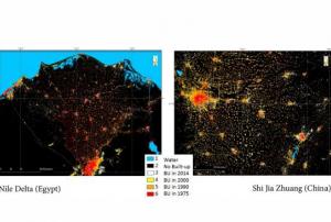 ,
, 
The Global Human Settlement (GHS) framework produces global open source spatial information about the human presence on the planet over time. This is in the form of built up maps, population density maps and settlement maps. This information is generated with evidence-based analytics and knowledge using new spatial data mining technologies. The framework uses heterogeneous data including global archives of fine-scale satellite imagery, census data, and volunteered geographic information. The data is processed fully automatically and generates analytics and knowledge reporting objectively and systematically about the presence of population and built-up infrastructures.
read more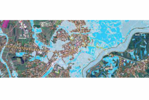 ,
, 
The guidelines will be reviewed and updated periodically, in order to integrate new best practices and to be responsive to evolutions in technology and end-user needs. The IWG-SEM chair has the responsibility to initiate the review, by agreement of the Working Group.
The production and the maintenance of the guidelines are based on a joint effort by the members of the International Working Group on Satellite-based Emergency Mapping (IWG- SEM), a voluntary group of organizations involved in satellite-based emergency mapping. It was founded to improve cooperation, communication and professional standards among the global network of satellite-based emergency mapping providers. The chairperson of the group is nominated for a term of one year and is responsible for organizing the monthly telecons and bi-annual meetings. The current chair is from the Department of Geoinformatics, Z_GIS University of Salzburg / Spatial Services Ltd, Austria…
read morePublishing institution: ,
,  ,
,  ,
, 
Intensive capacity development sessions for Pacific island countries (Cook Islands, Fiji, Kiribati, Micronesia (the Federated States of), Samoa, Solomon Islands, Tonga, and Vanuatu).
The project aims to enhance institutional and technical capacity for using geospatial data and technology applications and promote regional cooperation for sharing geospatial data for disaster management in Pacific island countries.
read morePublishing institution: ,
,  ,
,  ,
, 
Developed for the needs of the ASEAN sub-region in Asia and the Pacific, the handbooks can also be adapted for use in other regions.
The handbooks have been developed through expert working groups, in collaboration with United Nations partners including UNOOSA/UN-SPIDER, UNITAR-UNOSAT, and OCHA. As well as extensive consultation with space agencies, national disaster management authorities and regional institutions, including GISTDA, LAPAN, ASEAN Coordinating Centre for Humanitarian Assistance on Disaster Management and Asian Institute of Technology.
read morePublishing institution:") ,
, ") ,
, ")
For a comprehensive and objective analysis of the settlement patterns, the DLR additionally developed an approach to display the spatial networks between the mapped settlements. It enables the computation of various form and centrality measures to characterize settlement patterns, at different spatial units, ranging from global to local scale.
read morePublishing institution:
Term Parents
UN-SPIDER Regional Support Offices with hazard-specific expertise
![]()