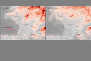
Scientists from the Royal Netherlands Meteorological Institute (KNMI) have been using data from Copernicus Sentinel-5P satellite, launched in 2017, to monitor both weather and pollution over Europe. The new images clearly illustrate a strong reduction of nitrogen dioxide concentrations over major cities across Europe. The analysis makes use of the satellite's high spatial resolution and ability to trace pollutants such as nitrogen dioxide, ozone, formaldehyde, sulphur dioxide, methane and carbon monoxide. With a resolution as high as 7 km × 3.5 km, it has the potential to detect air pollution over individual cities.