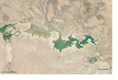
On July 8, 2013, the Operational Land Imager (OLI) aboard Landsat 8 captured impressive images of Elephant Butte Reservoir, when was only filled to 3% of its capacity, highlighting the impact that the drought has had on New Mexico. Created in 1915 and fed by the Rio Grande, Elephant Butte is New Mexico’s largest reservoir and is the responsible of providing water supply for about 90,000 acres (364 square kilometers) of farmland and about half the population of El Paso, Texas.
However, the drought of 2013 has severely damaged this distribution of water, as a result of the scarce rains and a supply of water from the mountains below the average. Furthermore, the water storage from the monsoon in early July was minimum at Elephant Butte.
Therefore when on July 8, 2013 Landsat 8 captured the image at the top, the total water in storage constituted only 3% of the reservoir’s capacity, an anemic level that has deeply affected farmers in this area, experiencing the shortest irrigation season on record. According to the sources, the last time water levels were that low was in 1972, in fact the picture at the bottom shows the reservoir on June 2, 1994, when it was at about 89 percent of capacity.

