NASA's Aqua and TRMM satellites are providing data to scientists about the Southern Atlantic Ocean Sub-tropical Storm Arani, a rare occurrence in the southern ocean. Rainfall data and cloud top temperatures revealed some heavy rain and strong thunderstorms exist in Arani as it continues to pull away from Brazil.
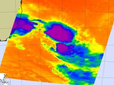
On March 15 at 1820 UTC (2:20 p.m. EST) NASA's Tropical Rainfall Measuring Mission (TRMM) satellite flew over Sub-Tropical Storm Arani. TRMM rainfall data showed that the storm contained mostly moderate rainfall, falling at a rate between 20 and 40 millimeters per hour. On March,16 another of NASA's fleet of Earth science satellites flew over Sub-tropical Storm Arani and took its temperature. Later on March 16, at 10:52 UTC , the TRMM satellite again passed over Sub-Tropical Storm Arani and noticed it still had some strong thunderstorms and was producing heavy rainfall off the Brazilian coast.
TRMM data was used to create a 3-D view of Sub-tropical Storm Arani's clouds, and it showed that there were very heavy thunderstorms in the eastern half of the storm. TRMM's Precipitation Radar showed that some of these powerful storms were reaching to heights of over 14 km (~8.7 miles) above the surface of the Southern Atlantic Ocean.
Arani has the appearance of a tropical cyclone but has been classified as a subtropical cyclone. Subtropical cyclones are low pressure areas that develop with a cold core and transition to a warm core in the mid-levels of the troposphere, resembling a tropical cyclone. They more typically form outside of hurricane season.