![]()
United
Nations
Volcanic Eruption
 on the Landsat 8 satellite acquired this top image of Mount Etna on December 28, 2018. The image highlights the active vent and thermal infrared signature from lava flows, which can be seen near the newly formed fissure on the southeastern side of the volcano. The image was created with data from OLI (bands 4-3-2) and the Thermal Infrared Sensor (TIRS) on Landsat 8. Image: NASA.")
Definition
Facts and figures
Further information
UN-SPIDER Regional Support Offices with hazard-specific expertise
Related content on the Knowledge Portal
 ,
, 
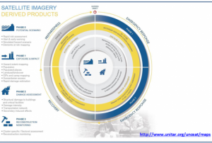
Based on optical and radar images of different resolutions, UNOSAT products are also enriched with the available baseline GIS datasets and crowdsourcing data. Satellite-derived analysis performed by UNOSAT is delivered in the form of GIS Data, Static Maps, Live Web Maps, and Reports, and is then shared with a wide range of end-users such as UN Agencies, International Organizations, and Governments.
Publishing institution: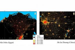 ,
, 
The Global Human Settlement (GHS) framework produces global open source spatial information about the human presence on the planet over time. This is in the form of built up maps, population density maps and settlement maps. This information is generated with evidence-based analytics and knowledge using new spatial data mining technologies. The framework uses heterogeneous data including global archives of fine-scale satellite imagery, census data, and volunteered geographic information. The data is processed fully automatically and generates analytics and knowledge reporting objectively and systematically about the presence of population and built-up infrastructures.
read more ,
, 
The guidelines will be reviewed and updated periodically, in order to integrate new best practices and to be responsive to evolutions in technology and end-user needs. The IWG-SEM chair has the responsibility to initiate the review, by agreement of the Working Group.
The production and the maintenance of the guidelines are based on a joint effort by the members of the International Working Group on Satellite-based Emergency Mapping (IWG- SEM), a voluntary group of organizations involved in satellite-based emergency mapping. It was founded to improve cooperation, communication and professional standards among the global network of satellite-based emergency mapping providers. The chairperson of the group is nominated for a term of one year and is responsible for organizing the monthly telecons and bi-annual meetings. The current chair is from the Department of Geoinformatics, Z_GIS University of Salzburg / Spatial Services Ltd, Austria…
read morePublishing institution: ,
,  ,
,  ,
, 
Intensive capacity development sessions for Pacific island countries (Cook Islands, Fiji, Kiribati, Micronesia (the Federated States of), Samoa, Solomon Islands, Tonga, and Vanuatu).
The project aims to enhance institutional and technical capacity for using geospatial data and technology applications and promote regional cooperation for sharing geospatial data for disaster management in Pacific island countries.
read morePublishing institution: ,
,  ,
,  ,
, 
Developed for the needs of the ASEAN sub-region in Asia and the Pacific, the handbooks can also be adapted for use in other regions.
The handbooks have been developed through expert working groups, in collaboration with United Nations partners including UNOOSA/UN-SPIDER, UNITAR-UNOSAT, and OCHA. As well as extensive consultation with space agencies, national disaster management authorities and regional institutions, including GISTDA, LAPAN, ASEAN Coordinating Centre for Humanitarian Assistance on Disaster Management and Asian Institute of Technology.
read morePublishing institution:") ,
, ") ,
, ")
For a comprehensive and objective analysis of the settlement patterns, the DLR additionally developed an approach to display the spatial networks between the mapped settlements. It enables the computation of various form and centrality measures to characterize settlement patterns, at different spatial units, ranging from global to local scale.
read morePublishing institution: ,
,  ,
, 
CEMS is a core service of the European Union’s Earth Observation programme Copernicus. It supports all phases of the disaster management cycle by delivering warnings and risk assessments of floods and forest fires and by providing geospatial information derived from satellite images on the impact of natural and man-made disasters all over the world (before, during or after a crisis). The two Mapping services of CEMS (Rapid Mapping, Risk and Recovery Mapping) are delivering products since April 2012. The Risk & Recovery Mapping provided for example information for preparedness, disaster risk assessment and risk reduction related to earthquakes in Nepal, several post-disaster assessments for flood and fire events, reconstruction and recovery monitoring in Haiti, and multi-risk assessments for the Azores Islands in Portugal.
CEMS is coordinated by the European Commission (joint coordination between the Directorate Generals ECHO, JRC, GROW). Activation requests…
read morePublishing institution:, modelled (middle), and residual deformation (data minus model; right) based on radar satellite data spanning the M5.6 earthquake near Chiles and Cerro Negro volcanoes in 2014, acquired by COSMO-SkyMed (top) and RADARSAT-2 (bottom) satellites. All deformation in the images can be explained by the earthquake, suggesting that any magma accumulation or transport associated with the episode of unrest was small or otherwise not detectable. (Image credit: Ebmeier") ,
,  shows ground displacement and active faults around Sabancaya volcano in Peru (black triangle). This data, along with satellite observations of increased temperature and other ground observations, allowed the Observatorio Vulcanológico del Sur (OVS), Instituto Geofísico del Perú to make informed decisions about the potential eruptive hazard - small eruptions occurred in 2014, 2015, and a continued threat further exist. (Image credit: Jay et al. 2015)")
CEOS Disasters Working Group Space agencies organised in the Committee on Earth Observation Satellites (CEOS) formed a permanent Working Group in 2013. Together with volcanologists and Remote Sensing specialists, a Volcano Pilot activity was started with the following aims:
- Demonstrate the utility of integrated, systematic space-based EO as a volcano monitoring tool on a regional basis and for specific case studies
- Provide space-based EO products to the existing operational community (such as volcano observatories and VAACs) that can be used for better understanding volcanic activity and reducing impact and risk from eruptions
- Build the capacity for use of EO data at the majority of the world‘s volcanoes (particularly those that are not monitored by other means)
After further specification, the main objective of the pilot activity consists of a regional study of volcanic unrest and eruptions in the Latin American volcanic arc (from…
read morePublishing institution:
 The main objective of the SENTINEL-3 mission is to monitor sea and land surface
temperature, sea surface topography and ocean and land surface colour with high accuracy and reliability. The high resolution data is meant to support ocean forecasting systems, environmental monitoring and climate monitoring.
ESA and EUMETSAT will jointly operate the SENTINEL-3 mission and bothy institutions provide access to the processed data.
Sentinel 3 carries four main instruments: the OLCI, SLSTR, Altimetry and a MWR Microwave Radiometer.
Publishing institution:
Term Parents
UN-SPIDER Regional Support Offices with hazard-specific expertise
![]()