![]()
United
Nations
Tsunami
 and the Ohio State University (OSU) used satellite altimeters to observe “merging tsunamis”. The image comes from a data-based computer model that shows Tohoku-oki tsunami waves propagation. Waves peaks are depicted in red-brown, while depressions in sea surface appear in blue-green. Grayscale outlines show the location of mid-ocean ridges, peaks, and islands. Image: NASA.")
Definition
Facts and figures
Further information
UN-SPIDER Regional Support Offices with hazard-specific expertise
Related content on the Knowledge Portal
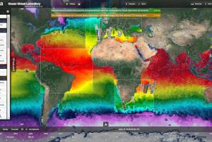 The Ocean Virtual Laboratory is a web platform making satellite and in-situ data for ocean monitoring accessible. It presents one of multiple Syntool Web portals that promote the synergistic use of Ocean Remote Sensing data in a wider context of Oceanic and Atmospheric models or in-situ data. , ESA/SEOM Ocean Virtual Laboratory portal:
SAR roughness Sentinel 1:
Ocean Color: From Sentinel-2, Sentinel-3 and Meteosat.
Chlorophyll: From VIIRS and MODIS
Sea Surface Temperature, Sea level, Salinity, Wind, Current, Rain, Mean Square Slope, Sea ice concentration
, ESA/DUE GlobCurrent portal:
SAR roughness, Ocean Color, Chlorophyll, Sea surface temperature, Sea level, Salinity, Wind, Wave, Current, Rain, ESA SMOS Storm portal: Significant Wave height (SWH) Jason 2 and ALTIKA, SAR roughness Sentinel-1, Wind speed SMOS, SMAP, AMSR2 and ASCAT, wind barbs ASCAT, CNES Aviso'VIZ altimetry portal: Sea Surface Height Anomaly (SSHA) Jason-2 and SARAL, Sea Level Anomaly (SLA) Jason-2 and SARAL, Absolute Dynamic Anomaly (ADT) Jason-2 and SARAL, Mean Sea Level RIse, Sea Level Anomaly, Geostrophic current vectors and streamlines., ESA Sentinel3 Viewer: products from OLCI, SLSTR and SRAL sensors., CNES PEPS Sentinel-1 Ocean Viewer: SAR roughness Sentinel-1, ESA Sea Surface Salinity portal: SMOS salinity, SMAP salinityPublishing institution:-
The Ocean Virtual Laboratory is a web platform making satellite and in-situ data for ocean monitoring accessible. It presents one of multiple Syntool Web portals that promote the synergistic use of Ocean Remote Sensing data in a wider context of Oceanic and Atmospheric models or in-situ data. , ESA/SEOM Ocean Virtual Laboratory portal:
SAR roughness Sentinel 1:
Ocean Color: From Sentinel-2, Sentinel-3 and Meteosat.
Chlorophyll: From VIIRS and MODIS
Sea Surface Temperature, Sea level, Salinity, Wind, Current, Rain, Mean Square Slope, Sea ice concentration
, ESA/DUE GlobCurrent portal:
SAR roughness, Ocean Color, Chlorophyll, Sea surface temperature, Sea level, Salinity, Wind, Wave, Current, Rain, ESA SMOS Storm portal: Significant Wave height (SWH) Jason 2 and ALTIKA, SAR roughness Sentinel-1, Wind speed SMOS, SMAP, AMSR2 and ASCAT, wind barbs ASCAT, CNES Aviso'VIZ altimetry portal: Sea Surface Height Anomaly (SSHA) Jason-2 and SARAL, Sea Level Anomaly (SLA) Jason-2 and SARAL, Absolute Dynamic Anomaly (ADT) Jason-2 and SARAL, Mean Sea Level RIse, Sea Level Anomaly, Geostrophic current vectors and streamlines., ESA Sentinel3 Viewer: products from OLCI, SLSTR and SRAL sensors., CNES PEPS Sentinel-1 Ocean Viewer: SAR roughness Sentinel-1, ESA Sea Surface Salinity portal: SMOS salinity, SMAP salinityPublishing institution: 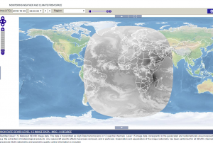 Map Viewer that allows downloading and time series creation of meteosat products.Publishing institution:
 Publishing institution:
") Publishing institution:
Publishing institution:") Publishing institution:
Publishing institution:
The Asia and Oceania regions are frequently affected by severe natural phenomena such as tropical cyclones, torrential monsoons, volcanic eruptions, yellow sandstorms, floods, sea ice, and wildfires. The importance of monitoring the climate and the environment is also increasing, which has prompted enhanced global interest in the field.
In this area, the new generation of meteorological and earth observation satellites provide frequent and extensive observational information for use in disaster prevention and climate monitoring/diagnostics; they are indispensable in today’s world. The Asia/Oceania Meteorological Satellite Users’ Conferences provide an excellent forum for satellite operators and users within the Asia/Oceania community to meet and enhance their joint efforts in the utilization of satellite data and products for better weather, climate, and disaster mitigation services.Objectives- Promoting satellite...
![Copernicus Emergency Management Service (© 2018 European Union), [EMSR317] Palu - Indonesia, Grading Map.](/sites/default/files/styles/w300_h202_covid_19_detail/public/Copernicus_EMSR317_07PALU_02GRADING_MAP_v2_100dpi.png?itok=k1oGg1mR "Copernicus Emergency Management Service (© 2018 European Union), [EMSR317] Palu - Indonesia, Grading Map.")
The International Charter “Space and Major Disasters” and the Copernicus Emergency Management Service Mapping have been activated on 29 September after a 7.5 magnitude earthquake in the central Indonesian Island of Sulawesi.
At least 844 people have been killed and 64,000 displaced according to reports.
The cities of Palu and Donggala are the worst affected areas by the earthquake and a tsunami with waves as high as six metres.
The International Charter was activated by the Asian Disaster Reduction Centre (ADRC) on behalf of the Indonesian National Institute of Aeronautics and Space (LAPAN). Both institutions are UN-SPIDER Regional Support Offices (RSO). Mapping products made available under the activation are available on the...
read moreRegional Support Offices mentioned:01/10/2018 of 2.7 m (i.e., less than one floor) and the share of built-up area could be estimated with a MAE of 13.3 %, when compared to a reference data set.") Publishing institution:
Publishing institution:
Term Parents
UN-SPIDER Regional Support Offices with hazard-specific expertise
![]()