![]()
United
Nations
Sécheresse
 instrument aboard ESA’s Envisat satellite. Image: ESA, CC BY-SA 3.0 IGO.")
Definition
Facts and figures
Further information
UN-SPIDER Regional Support Offices with hazard-specific expertise
Related content on the Knowledge Portal
The future of Earth is at stake as the world grapples with a climate changing at rates unprecedented in human times. Climate change is fueling a growing gulf of economic and social inequity, shrinking the scope of biodiversity, turning fallow the agricultural lands needed to feed humanity, and eating away at our common heritage through the destruction of world heritage sites. These challenges manifest as massively disruptive forces in the lives of individuals and communities which, through a multitude of mechanisms ranging from dysfunctional governance to unhealthy industrial practices, feed back into anthropogenic induced climate change and concomitant causes of disaster. Arid regions are particularly susceptible to climate change due to a natural scarcity and fragility of resources which are already combining to drive social unrest caused by hunger, forced human migration, and related economic misfortune.
Droughts are a recalcitrant problem in arid regions and are…
read more
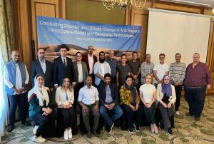
The Center for Remote Sensing of Land Surfaces (ZFL) of the University of Bonn in Germany (German Regional Support Office of UN-SPIDER) is organizing an online training on 16 December 2022. It aims to provide an overview of Copernicus tools and data in the context of floods and droughts. With the help of the tools and platforms presented during this training, participants will be able to make use of earth observation data in the context of floods and droughts without the need of extensive background knowledge. There will be a focus on African examples throughout the training. The training is specifically meant for participants from African countries from government agencies, academia, NGOs or other institutions involved in disaster management or risk reduction.
Find more information and the registration link…
read moreRegional Support Offices mentioned:09/12/2022
Floods and droughts are some of the most frequent natural disasters that can become a major threat to livelihoods, food-security, infrastructure and even life. Remote sensing and earth observation provide valuable tools to monitor ongoing floods and drought, assess the current situation from space and produce products that can support stakeholders and decision makers.
This training is organized by the Center for Remote Sensing of Land Surfaces (ZFL) of the University of Bonn in Germany and aims to provide an overview of Copernicus tools and data in the context of floods and droughts. With the help of the tools and platforms presented during this training, you will be able to make use of earth observation data in the context of floods and droughts without the need of extensive background knowledge. There will be a focus on African examples throughout the training. The training is specifically meant for participants from African countries from government agencies, academia,…
read more
Excerpt from article by Giriraj Amarnath, IWMI
Experts at COP 27 have made apocalyptic forecasts of weather under climate change if urgent action is not taken. In South Asia, the anticipated ‘climate chaos’ is already a reality for many, with extreme droughts and floods increasingly affecting the region. According to the World Bank, losses will average USD 160 billion per year by the end of this decade if current trends continue. If South Asian nations and communities are to cope as climate change progresses, they need advance warning of extreme events, so they can put mitigation plans into action, and avoid climate hazards becoming major disasters.…
read moreRegional Support Offices mentioned:02/12/2022
The event was organised by the SAARC Disaster Management Centre with support from the UN-SPIDER programme of the UN Office for Outer Space Affairs and International Water Management Institute (IWMI), one of the 26 regional support offices of UN-SPIDER, and the Indian Council of Agricultural Research. The workshop was attended by over 25 participants from Bangladesh, India, Maldives, Nepal, Pakistan and Sri Lanka.
Drought is one of the most devastating natural disasters in the world. South Asia has faced several droughts in recent decades and 50 major droughts reported Since 1990 and affecting a population of over 750 million and economic damages estimated at 7 billion USD. Droughts are projected to be more frequent and prolonged in the arid and semiarid areas of India, Pakistan, and Bangladesh. Being able to accurately identify and monitor drought is therefore of considerable importance. Thus, monitoring the severity and its impact on drought is critical for drought risk…
read more01/09/2022
The European Commission’s Joint Research Centre today published the “Drought in Europe - July 2022” report, an assessment of Europe’s drought situation based on the European Drought Observatory.
The analysis of the evolution and impact of the prolonged drought in the EU shows that a staggering portion of Europe is currently exposed to warning (44% of EU+UK) and alert (9% of EU+UK) drought levels, associated with soil moisture deficit in combination with vegetation stress.
[...]
The Joint Research Centre produces real-time drought information through the European and Global Drought Observatories (EDO and GDO), which are part of the…
read more19/07/2022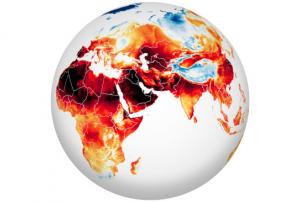
In June and July 2022, heatwaves struck Europe, North Africa, the Middle East, and Asia, as temperatures climbed above 40 degrees Celsius (104 degrees Fahrenheit) in places and broke many long-standing records.
The map above shows the surface air temperatures across most of the Eastern Hemisphere on July 13, 2022. It was produced by combining observations with a version of the Goddard Earth Observing System (GEOS) global model, which uses mathematical equations to represent physical processes in the atmosphere.
“While there is a clear pattern of an ‘atmospheric wave’ with alternating warm (redder) and cool (bluer) values in different locations, this large area of extreme (and record breaking) heat is another clear indicator that emissions of greenhouse gases by human activity are causing weather extremes that impact our living conditions,” said Steven…
read more18/07/2022
Text adapted from https://eo-college.org
Welcome to the ‘Hazards and Disasters’ online courses. In the three MOOCs which are part of it, we will take a closer look at how remote sensing can answer essential questions related to the emergency response that is needed during hazardous events. Thus, disaster management heavily relies on remotely sensed data and their prompt processing in order to support decisions that can a) estimate the extent of a (natural) disaster and b) save lives by scientifically justifiable choices.
In the three lessons of this course, we will present different applications of remotely sensed data for disaster monitoring to you. At first, we will take a look at droughts, then dive into mapping flood extents using an interactive cloud-based approach before ending our course with the monitoring of fire hazards.
In the lessons listed below, you will be doing the…
read more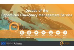
Implementing science to save lives: A Decade of the Copernicus Emergency Management Service
The Copernicus Emergency Management Service (CEMS) celebrates a decade of operation as a world leader in emergency mapping, early warning tools and open-access disaster information.
For the past ten years, CEMS has provided a global service as a fully operation emergency mapping service at no cost to users and with open access data.
Some highlights on the contribution of CEMS in global disaster risk management activities:
- 576 Rapid Mapping Activations with 5,500+ maps delivered
- Designed and implemented the world’s first Global Flood Monitoring tool
- Ten years of wildfire forecasts up to ten days into the future
- Average of 200+ flood and 500+ flash flood notifications to Member States and authorised users each year
- Offers a current and historical database of 7,000+ drought episodes since 1950
…
read more22/06/2022 Publishing institution:
Term Parents
UN-SPIDER Regional Support Offices with hazard-specific expertise
![]()