INFORM report 2024 launched

Since the end of the 1990s, many countries around the world began to implement the notion of disaster risk management as a paradigm shift to enable a shift from the existing and reactive disaster response efforts to a more proactive way of addressing the root causes of risks.  This new framework introduced the notion of risk as the set of pre-existing conditions that represented the predisposition of an asset, a livelihood, a community, a city, a province, or a country to be affected by a natural hazard.

spencer.zinke Mon, 25 Mar 2024 - 13:14
UN-SPIDER Regional Support Offices Meeting 2024

The Regional Support Offices Meeting 2024 was recently conducted by UN-SPIDER at UN Campus in Bonn. The meeting was conducted following the UN-SPIDER Bonn International Conference on Space-based Solutions for Disaster Management: Early Warnings for All, of which many of the Regional Support Office representatives also attended. 

spencer.zinke Mon, 18 Mar 2024 - 14:39
UN-SPIDER hosts International Conference on Space-based Solutions for Disaster Management: Early Warnings for All

From 12 to 14 March 2024, the UN-SPIDER programme of the United Nations Office for Outer Space Affairs, the German Aerospace Center (DLR) the Center for Remote Sensing of Land Surfaces (ZFL) of the University of Bonn joined forces to organise the UN-SPIDER Bonn International Conference on Space-based Solutions for Disaster Management - "Early Warnings for All".

spencer.zinke Tue, 12 Mar 2024 - 12:23
New UNOOSA/UN-SPIDER Publication: Space Technologies for Early Warning Systems

UN-SPIDER launched a new publication: “Space-based Technologies for Early Warning Systems” during its currently ongoing conference.

You can access the pdf version of the publication using this link.

martin.hilljegerdes Tue, 12 Mar 2024 - 10:39
OCHA Publication: The State of Open Humanitarian Data 2024

As part of their 10 year anniversary, the Centre for Humanitarian Data, under the United Nations Office for the Coordination of Humanitarian Affairs (OCHA) has released a publication reviewing the progress of its open-access data platform, the Humanitarian Data Exchange (HDX), providing insights as to the future plans and contribution needs for the platform.

spencer.zinke Fri, 1 Mar 2024 - 12:37
Copernicus Coastal Hub spencer.zinke Wed, 28 Feb 2024 - 14:27
rfree
arch
exportdata
visdata
drm
rr
The Copernicus Coastal Hub offers free and openly accessible geospatial information for download regarding subject that impact coastal regions around the world.
Prolonged Droughts Cause Critical Impacts in the Mediterranean and Northern Africa

For six years in Northern Africa and two years in Europe, persistent droughts have caused critical impacts such as water shortages and decreased vegetation growth. In the midst of winter, the ongoing drought is already having critical impacts, according to the report compiled by the JRC-run European Drought Observatory (EDO). Above-average temperatures, minimal precipitation, and warm spells affect the Mediterranean regions.

josi.bregulla Mon, 26 Feb 2024 - 15:34
Tracking Oil Spill in Trinidad and Tobago Using Sentinel-1 Imagery
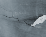
On the 7th of February 2024, a vessel in proximity to Tobago’s southern coastline was found to be capsized and leaking oil into the sea. While local authorities continue to deal with the ongoing issue, satellite imagery shows how this oil spill is progressing. Using satellite radar imagery gathered from the Copernicus Sentinel-1 mission and processed by the ESA, we can see how far the oil spill has traveled thus far. As of the 14th of February, the imagery shows that the oil spill has spread for more than 160 km westward, and may affect neighboring Grenada and Venezuela.

spencer.zinke Mon, 26 Feb 2024 - 15:19
Indian Space Research Organisation Launches Meteorological Satellite INSAT-3DS
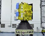
On Saturday, 17 February 2024, the Indian Space Research Organisation (ISRO) successfully launched a meteorological satellite into Geostationary Orbit. This satellite is designed to provide support, including disaster warnings, among other functions.

The INSAT-3DS satellite is a component of the GSLV-F14/INSAT-3DS mission and is funded by the Ministry of Earth Sciences (MoES). The mission aims to achieve enhanced meteorological observations and improve monitoring of land and ocean surfaces.

josi.bregulla Fri, 23 Feb 2024 - 16:21