UN-SPIDER at a glance
 23/08/2018Regional Support Offices involved: Asian Disaster Reduction Center (ADRC), International Water Management Institute (IWMI)
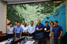
UN-SPIDER is working with the Viet Nam Ministry of Agriculture and Rural Development (MARD), the Viet Nam Disaster Management Authority (VNDMA) and the Disaster Management Policy and Technology Center (DMPTC) to promote the use of space-based information in disaster management.
From 13 to 17 August 2018, a team of experts led by UN-SPIDER visited Viet Nam upon… Read more
 21/08/2018
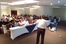
UN-SPIDER and the National Secretariat for Science and Technology of Guatemala (SENACYT) joined forces to conduct a seminar on the use of science, technology and innovation in disaster risk reduction and response efforts. The seminar was conducted in Guatemala City on 24 July 2018 as part of the week-long CONVERCIENCIA 2018 event organized by SENACYT. The seminar brought together experts from… Read more
 16/08/2018Regional Support Offices involved: International Water Management Institute (IWMI)
The United Nations Office for Outer Space Affairs (UNOOSA) has activated the International Charter “Space and Major Disasters” for Typhoon Bebinca in Viet Nam, which is expected to make landfall on 17 August. UNOOSA activated the Charter on behalf of the Vietnam Disaster Management Authority.
Meteorologists have forecasted wind speeds up to 90 kph and up… Read more
News from the community
 28/08/2018
The European Space Agency (ESA) launched the much-awaited Aeolus satellite into orbit on 22 August. It will provide data expected to improve weather forecasting and contribute to better disaster management.
Aeolus - the “Keeper of Winds” in Greek mythology - aims to track and profile global wind better. Aeolus uses the Active Doppler Wind Lidar (DLR)… Read more
 24/08/2018
In May 2018, Planet joined the International Charter “Space and Major Disasters” as an approved data contributor, providing the Charter with 3.7 million Planetscope data from the largest fleet of miniature Earth imagery satellites operated by Planet. Planet's constellation of microsatellites will add to the Charter's ability to respond effectively to calls after… Read more
 20/08/2018
The United Nations (UN) Statistics Division and the World Bank have published a new guide aimed at supporting nations worldwide, in particular, developing nations, in better utilizing geospatial data in the decision-making process. The “Integrated Geospatial Information Framework”, launched on 24 July 2018, provides a strategic guide on establishing national geospatial… Read more
 17/08/2018
A break in the heat wave that hit Europe in the summer of 2018 is giving a reprieve to many people who had been suffering from the heat. However, great damages to the vegetation and harvest remain. In Germany, the Association of Farmers … Read more
 16/08/2018
The International Charter “Space and Major Disasters” has been activated for floods in Venezuela on 15 August and in India on 16 August.
Floods in Venezuela
In Venezuela, persistent heavy rain and swollen rivers have caused severe flooding, which has affected over 10,000 people in the Venezuelan provinces of Amazonas, Apure, Bolivar and… Read more
 10/08/2018
A new European Space Agency (ESA) project aims to allow developing countries to have greater access to powerful Earth observation tools in order to reduce risks linked to natural disasters such as earthquakes, floods or volcanic eruptions.
ESA’s Earth Observation for Sustainable Development initiative (EO4SD) will encourage International… Read more
. Image: JAXA") 08/08/2018
08/08/2018The Japanese Aerospace Exploration Authority (JAXA) has released a collection of good practices in disaster emergency observation using data captured by the Advanced Land Observing Satellite-2 "DAICHI-2" (ALOS-2) from 2014 to 2017. The publication showcases the contributions of space technology to disaster risk reduction and demonstrates Synthetic Aperture Radar (SAR)… Read more
 07/08/2018
The International Charter “Space and Major Disasters” has been activated on 6 August after a 6.9 magnitude earthquake struck the island of Lombok, Indonesia.
At least 98 people have been killed and 10,000 have been evacuated after a 6.9 magnitude earthquake struck off the coast of Lombok, destroying buildings and cutting power. The neighbouring islands of… Read more
 data. Image: Copernicus") 02/08/2018
02/08/2018The African Union (AU) Commission signed a Cooperation Arrangement with the European Commission (EC) in Brussels on 12 June 2018 to facilitate AU’s access to Earth observation data from the Sentinel satellites of the Copernicus Programme.
Under the agreement, the AU Commission, African public users and African disaster management agencies will be able to access… Read more
News from our Regional Support Offices
 15/08/2018Regional Support Offices involved: International Centre for Integrated Mountain Development (ICIMOD)
According to a recent report published by the International Centre for Integrated Mountain Development (ICIMOD), space-based information can play a key role in the monitoring of agricultural droughts and forest fires. The "Building Mountain Resilience: Solutions from the Hindu Kush Himalaya" report examines the changing problems facing the Himalayan region of South Asia and… Read more
| Title | Organized by | City | Country | Date |
|---|---|---|---|---|
| UN/Costa Rica/PSIPW Sixth conference on the use of space technology for water management | United Nations Office for Outer Space Affairs (UNOOSA) Government of Costa Rica Prince Sultan Bin Abdulaziz International Prize for Water (PSIPW) |
San José | Costa Rica | 05/07/2024 to 05/10/2024 |
| 3rd International Conference Natural Hazards and Risks in a Changing World | Amsterdam | Netherlands | 06/12/2024 to 06/13/2024 | |
| 43rd EARSeL Symposium | European Association of Remote Sensing Laboratories (EARSeL) |
Manchester | United Kingdom of Great Britain and Northern Ireland | 06/17/2024 to 06/20/2024 |
| 67th Session of the Committee on the Peaceful Uses of Outer Space (COPUOS) | Vienna | Austria | 06/19/2024 to 06/28/2024 | |
| EUMETSAT Meteorological Satellite Conference 2024 | European Organisation for the Exploitation of Meteorological Satellites (EUMETSAT), Deutscher Wetterdienst (DWD) |
Würzburg | Germany | 09/30/2024 to 10/04/2024 |
| 2nd UNESCO IOC Global Tsunami Symposium | United Nations Educational, Scientific and Cultural Organization (UNESCO); Meteorological, Climatological and Geophysical Agency (Indonesian: Badan Meteorologi, Klimatologi, dan Geofisika, abbreviated BMKG) |
Banda Aceh | Indonesia | 11/09/2024 to 11/14/2024 |