Dear readers,
We're glad to share with you the May 2020 UN-SPIDER Monthly Updates, and would like to make you aware of three new user stories we have recently published on our Knowledge Portal. These stories outline how satellite radar imagery helps analyse the deformation of the cones of volcanoes before and after an eruption.
To highlight areas where space-based information is used to support disaster management efforts, the UN-SPIDER team regularly compiles overviews of relevant applications. All so-called Data Applications of the Month are now also available in Spanish, as is our Recommended Practice on burn severity mapping using Google Earth Engine.
Enjoy the read!
UN-SPIDER at a glance
- 26/05/2020
The United Nations Office for Outer Space Affairs (UNOOSA) and the Space Generation Advisory Council (SGAC) have launched the second edition of their Space4Youth competition. Under the title Space4Climate, this year's focus is on SDG 13, Climate Action. In order to participate, students and young professionals from any Member State of the United Nations… Read more
Country/Region mentioned: - 08/05/2020Regional Support Offices involved: International Water Management Institute (IWMI)
On 14 May, the United Nations Office for Outer Space Affairs (UNOOSA) hosted two sessions of a webinar on space applications to support global health, including to fight coronavirus.
During the 90-minute sessions, experts from UNOOSA, as well as from other international organisations, governments and private sector companies… Read more
Country/Region mentioned:
News from our Regional Support Offices
- 11/05/2020Regional Support Offices involved: International Water Management Institute (IWMI)
The International Water Management Institute (IWMI) and Digital Earth Africa (DEA) have partnered to develop tools and applications that will support water resource management and water security in Africa. The applications will use remote-sensing and machine learning technologies and will produce measurements… Read more
Country/Region mentioned:
News from the community
- 19/05/2020
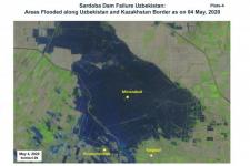
Using space-based information, the Centre for Space Science and Technology Education in Asia and the Pacific (CSSTEAP) affiliated to the United Nations has analysed the recent failure of a dam around the Sardoba Reservoir in Uzbekistan. Following a week of heavy rain in the region, the wall of the dam broke on 1 May and flooded surroundings in Uzbekistan… Read more
Satellite(s) and sensor(s) used:Country/Region mentioned: - 11/05/2020
A recent study has produced a 20-year time series of primary production by marine phytoplankton, one of the largest fluxes of carbon on our planet. Studying phytoplankton primary production is important because it provides useful information about ocean biology, climate, and global carbon cycle. Observing primary… Read more
Country/Region mentioned:


