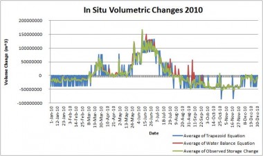
Current regional and global scale hydrological models, such as the Coupled Routing and Excess STorage (CREST) model, do not take into account the release and storage of water by man-made dams. These models make gross assumptions about dam operation, impairing their accuracy and utility. In many less economically developed areas of the world, it is not possible to acquire information on the timing and extent of water release in dammed regions. Therefore, a remotely sensed-based solution to this problem is highly desirable. Flow rate estimations can be computed by intersecting surface water extent maps with digital elevation models (DEMs). Moderate Resolution Imaging Spectroradiometer (MODIS) land surface reflectance data provided the basis for area calculations for the water extents, while the HydroSHEDS DEM provided elevation data. Together, the area and elevation measurements produced the volumetric changes in dams, which are necessary for accurate hydrological modeling. This concept was tested with preliminary volume equations based upon in-situ data. Preliminary volume equations based upon in-situ stream flow measurements from the U.S. Army Corps of Engineers were used to provide a proof-of- concept for flow rate estimations. Since many drainage basins contain man-made water bodies, this predictive tool will ultimately improve hydrological models around the world, specifically those used by our partners in the DisasterAWARE program at the Pacific Disaster Center.
For more information you can find the poster presentation under the source link