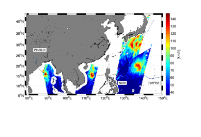
ESA’s Soil Moisture and Ocean Salinity satellite, SMOS, captured three superstorms have been affecting Asia over the past three weeks. Cyclone Phailin began forming on 4 October in the Gulf of Thailand, before moving northwest across the Bay of Bengal and making landfall in northern India. The storm affected about 12 million people and claimed dozens of lives. Typhoons Nari and Wipha subsequently formed on 8 October: Nari west of the Philippines and Wipha east of Guam. Nari displaced tens of thousands of people in the Philippines and Vietnam, while Wipha lashed Japan’s east coast.
ESA elaborates on their website: "During all three superstorms, ESA’s Soil Moisture and Ocean Salinity satellite, SMOS, captured snapshots of surface wind speeds under the intense storms.SMOS carries a novel microwave sensor to capture images of ‘brightness temperature’. These images correspond to radiation emitted from Earth’s surface, which are then used to derive information on soil moisture and ocean salinity."
This video shows how SMOS makes sea surface observations during tropical storms:

