Abdoulaye Dieye, GIS Officer, United Nations Office for the Coordination of Humanitarian Affairs, Regional Office for West and Central Africa (UNOCHA/ROWCA)
Context
Since 2007, the flood situation in West Africa is becoming more and more recurrent and the impact on the population and infrastructures is becoming more severe.
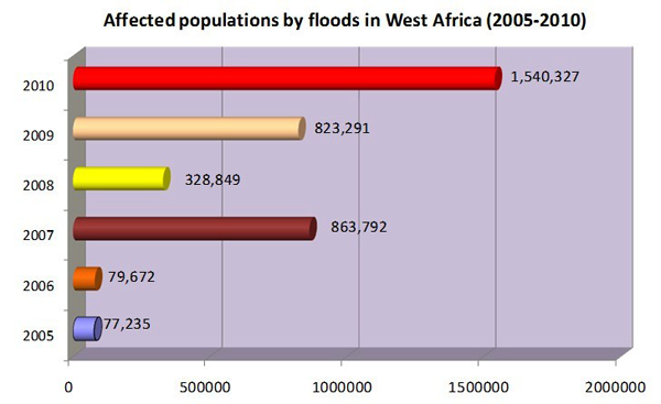
Figure 1: Flood affected populations in West Africa during the last 5 years. Sources: Data from 2005, 2006, 2008: CRED. Data from 2007, 2009, 2010: OCHA.
Since 2009, the United Nations Office for the Coordination of Humanitarian Affairs/Regional Office for West and Central Africa (UNOCHA/ROWCA) has been working closely with the UN Platform for Space-based Information for Disaster Management and Emergency Response of the United Nations Office for Outer Space Affairs (UNOOSA/UN-SPIDER), other UN entities (the World Food Programme (WFP), the Operational Satellite Applications Programme of the UN Institute for Training and Research (UNITAR/UNOSAT), etc.), members of the International Charter Space and Major Disasters (International Charter) for obtaining satellite imagery and rapid mapping, members of the European Services and Applications for Emergency Response (SAFER), governments, and NGOs to support emergency response and risk reduction efforts with geospatial information and rapid mapping.
Flood impact profile in West Africa in 2010
The year 2010 is generally marked by a relative humidity higher than in previous years with heavy rains between June and October over the sub-region of West Africa. Devastating floods are observed in almost all countries of the sub-region with over 1.5 million affected people and over 300 deaths. Significant damages were also noted on socio-economic infrastructures with houses, roads, bridges, hospitals, and schools destroyed, thousands of hectares of farmland and crops washed away, and livestock decimated. Benin is the most affected country with about 690,000 affected people, 86 deaths and 86,000 hectares of farmland damaged. Benin is followed by Nigeria (300,000 Internally Displaced Persons), Niger (226,000 affected people), and Burkina Faso (over 105,000 affected people).
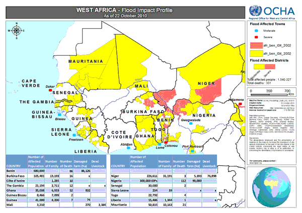
Figure 2: Map of floods impact profile in West Africa
Mechanism of coordination and communication for geo-spatial information and rapid mapping support
Within their respective roles to facilitate the coordination of humanitarian affairs and space affairs, UNOCHA/ROWCA works closely with the UNOOSA/UN-SPIDER to facilitate the activation of mechanisms for spatial information and rapid mapping support (the International Charter, SAFER, etc.) in West Africa.
Mechanism used by UNOCHA to request Charter and SAFER activation in Burkina Faso, Senegal and Benin in 2010
After an alert from the press, local UN Offices, NGOs, or the Government, UNOCHA requests support through the UN-SPIDER SpaceAid Framework and indicates its needs in consultation with UN-SPIDER experts and the UN-SPIDER National Focal Point. UN-SPIDER forwards the request to all partners of the Framework. The project manager who is nominated by the providers (UN-SPIDER partners) works closely with the different stakeholders (UN-SPIDER, UNOCHA, Government). The maps and spatial data are disseminated on the Knowledge Portal and the links are shared to UNOCHA and the National Focal Point as end users. These products are shared to humanitarian partners (UN Offices, NGOs, governments, etc.) to facilitate their activities in the field. A user feedback form is filled in at the end of the support mechanism to evaluate the process.
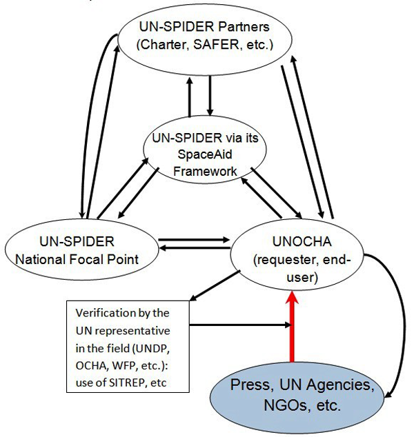
Figure 3: Schematic of the mechanism used to activate SAFER and the International Charter for Burkina Faso, Senegal and Benin.
Examples of spatial information and rapid mapping support in West Africa
In 2009, the International Charter was activated to obtain satellite imagery and support in rapid mapping for Benin, Senegal, Burkina Faso, Niger and Mauritania.
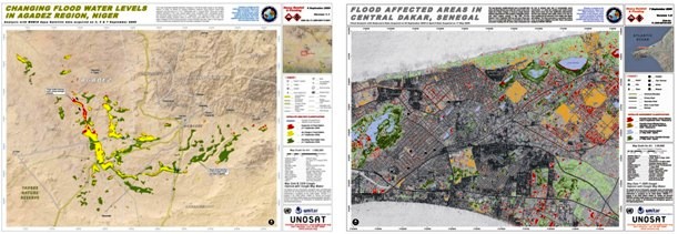
Figure 4: Maps of flooded areas in Agadez (Niger) and Dakar (Senegal) obtained after processing of satellite images from the International Charter.
In 2010, SAFER has been activated for three countries (Burkina Faso, Niger and Senegal), the International Charter for two countries (Benin and Nigeria).
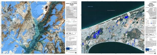
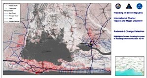
Figure 5: Maps of flooded areas in Sampelga (Burkina Faso) and Dakar (Senegal) obtained after processing of satellite images from SAFER, and Cotonou (Benin) from the International Charter.
These activations were supported by UN-SPIDER as well as by the European Union, the European Space Agency (ESA), the United States Geological Survey (USGS), the German Aerospace Center (DLR) and others. The image processing and rapid mapping were done by UN-SPIDER partner institutions (DLR for SAFER, UNITAR/UNOSAT and the Pacific Disaster Center for the International Charter).