1. Background and Objective
With the “Best Practices Booklet”, knowledge has been provided on what can be done with appropriate geoinformation to support disaster management: methods, systems, applications, experiences. As a next logical step it would be useful to provide information on what it is worth: an evaluation of benefits. A publication to that end would further help
- to raise awareness in the political and programmatic environment and
- to set priorities in research and development.
The intention is to produce a publication to give evidence of the economic, humanitarian, operational and organizational benefit which can be realized by applying geoinformation to disaster management, based on analyses of representative cases, and expert stakeholder assessment as well. The expected outcome is a differentiated, scientifically founded answer to the crucial question: “What is the difference you can make with geoinformation?”
2. Methodical Approach
By the classical Cost-Benefit-Analysis (CBA) approach the costs of an investment are compared with the monetary value of societal and economic benefits generated thereby. Whereas the costs of a given geoinformation product can be easily assessed by any geodata or GIS provider, monetizing societal benefit is more complicated and fuzzy. For example, a comprehensive socio-economic Benefits Analysis has been performed for the services offered by the European GMES programme, including issues of risk and civil protection. An alternative approach, based on evaluation of reference information products through expert stakeholders, was followed to assess the potential benefits of satellite remote sensing application to the mandatory tasks of the German Federal Ministry for Environment and Nuclear Safety.
Both approaches are applied in this project, taking into account that the monetized benefit analysis will probably lend itself more readily to assess the impact of geoinformation products in the phase of early emergency response, when there is a more immediate relationship between information availability and efficiency of relief measures. In addition, an expert stakeholder assessment is the method of choice to evaluate the benefits of geospatial information products with regard to all phases of the disaster management cycle, including prevention and risk reduction.
For a logic flow chart outlining the overall methodology see Fig. 1.
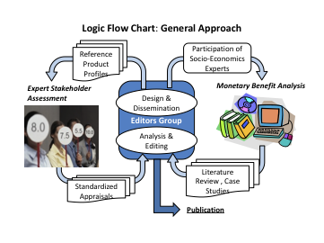
Figure 1: General Approach
2.1 Socio-Economic Benefit Analysis
Work in this context is focused on a thorough review of published papers covering the cross-sectional field of geoinformation, disaster management, and cost-benefit analysis. Dependent on the availability of funds, this literature-based approach is to be complemented by scenario-based case studies addressing recent major disasters.
The expected outcome will be a critical literature overview, highlighting benefits as well as shortcomings and needs, and specifying the particular effects of physical, societal and organizational boundary conditions. Topical case studies are conducted in order to exemplify and quantify major conclusions from the literature review.
2.2 Expert Stakeholder Assessment
This approach is intended to tap the implicit knowledge of the global stakeholder community with regard, from the user perspective, to the practical value of geoinformation under specific aspects of disaster management.
In the essence, a reference portfolio of representative geodata products and information systems is described in terms of major user-relevant features. The resulting product profiles are communicated to the global user community, together with a template for standardized product appraisal. The template specifies criteria related to various aspects of benefit, addressing the likely impact on operational as well as administrative and political issues in disaster management. The evaluators group represents expert stakeholders, i.e. actual or potential users, not providers, of geospatial data products in disaster management. The term “users” is understood to comprise practitioners as well as planners and deciders, affiliated in public disaster management bodies, international organizations and NGOs. These experts are invited to evaluate, by means of a standardized appraisal key, all reference items according to the beneficial impact which can be attributed to their application, and also to assess the criticality of specific product features. The outcome is a differentiated, semi-quantitative evaluation of specific benefits, which are supplemented by a cost estimate. For sake of unbiased judgment, cost estimates are not disclosed to the evaluators in advance.
The global stakeholder community is involved already in the selection of the reference geodata products/systems. To this end, a web-based poll is carried out, where all stakeholders are given the opportunity to identify the 10 most important geodata products on a longlist containing 51 items which have been identified from the JBGIS/UNOOSA “Best Practices Booklet” and from the Space Application Matrix on the UN-SPIDER Knowledge Portal. Stakeholders may be end users, providers or value adders of geoinformation. According to the poll results the shortlist of reference products/systems is defined and disseminated for appraisal, as described above.
The assessment results are analyzed with respect to, e.g., thematic distribution and clustering, geographical distribution, disaster types addressed, disaster management cycle phases covered, critical priorities, cost-benefit relations, major benefit issues, etc.
For an overview on the complete Expert Stakeholder Assessment process see Fig. 2.
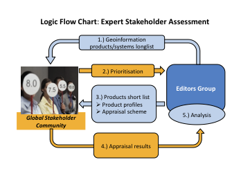
Figure 2: Methodology for Expert Stakeholder Assessment