Nepal

country taxonomy block

This article is a republished news article, created and originally published by the International Centre for Integrated Mountain Development (ICIMOD) under a Creative Commons license. Read the original article here.

Author: Utsav Maden, Knowledge Management and Communication Officer, ICIMOD

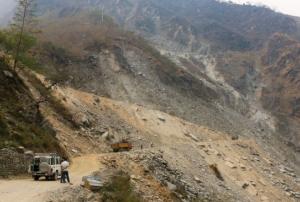
Nepal faces a double whammy of floods and landslides every year. Often considered a secondary hazard, landslides are usually triggered by incessant rainfall falling upon hilly and unstable slopes in Nepal’s predominantly mountainous terrain. As Nepal lies at the cusp of the Indian and Tibetan tectonic plates, it is more susceptible to earthquakes and resulting landslides. Unplanned road building and construction along unstable mountain slopes on relatively young mountain terrain…

more
Publishing date 24/01/2023

Excerpt from article by Giriraj Amarnath, IWMI

Experts at COP 27 have made apocalyptic forecasts of weather under climate change if urgent action is not taken. In South Asia, the anticipated ‘climate chaos’ is already a reality for many, with extreme droughts and floods increasingly affecting the region. According to the World Bank, losses will average USD 160 billion per year by the end of this decade if current trends continue. If South Asian nations and communities are to cope as climate change progresses, they need advance warning of extreme events, so they can put mitigation plans into action, and avoid climate hazards becoming major disasters.…

more
Publishing date 02/12/2022
Regional Support Offices mentioned:

The International Centre for Integrated Mountain Development (ICIMOD) is leveraging space-based information to support government and humanitarian agencies in the Hindu Kush Himalayan (HKH) region with timely information for flood early warning and inundation mapping. The efforts, which consist of developing a streamflow prediction system for flood early warning and of providing near real-time flood maps for disaster response, come as the monsoon floods in the region are worsening and compunding the impacts of the COVID-19 pandemic.

Based at ICIMOD, the streamflow prediction system to support flood early warning is being developed through the SERVIR-HKH initiative, which benefits from technical assistance from NASA and the Bringham Young University. The system provides 15-day streamflow…

more
Publishing date 19/08/2020

At the end of 2019, countries in the Horn of Africa began to suffer the impacts of locust swarms. Later, the locust migrated to regions in Southwest Asia. Unfortunately, the impacts on farmers are devastating. Furthermore, the combined impact of these locust plague and COVID-19 is having a toll of the livelihoods of many farmers in these regions. The Food and Agriculture Organization of the United Nations (FAO) has indicated that 42 million people are facing severe acute food insecurity because of this plague.

Since the end of 2019, the Aerospace Information Research Institute (ARI) of the Chinese Academy of Sciences (CAS) has been tracking the temporal and geospatial dynamics of the locust plague in the Horn of Africa, Eastern Africa, the Middle East and Southwest Asia. To track this plague, experts from the Vegetation Remote Sensing & Pest and Disease Application Research Team of ARI developed the Vegetation Pests and Diseases…

more
Publishing date 13/08/2020

In July 2019, Bangladesh, India and Nepal experienced floods and landslides during the South Asian monsoon season. On the night of the 17 July, the Jamuna river in Bangladesh broke through the embankment, inundating over 40 villages and displacing more than 200,000 people. Experts of the International Centre for Integrated Mountain Development (ICIMOD), a UN-SPIDER Regional Support Office, prepared flood inundation maps after the floods struck Bangladesh. By making use of free satellite data from the Sentinel-1 satellite of the Copernicus programme, ICIMOD experts were able to create maps that give a synoptic overview of the extent of inundation caused by the floods.

Flood inundation maps aid disaster management agencies in prioritizing relief and rescue missions in flood affected areas. These endeavors illustrate the usefulness of satellite data in emergency response: Maps play a crucial role in planning effective and efficient emergency response missions…

more
Publishing date 25/09/2019

On 12 March, Nepal Telecommunications Authority (NTA) signed an agreement with French satellite operator Thales Alenia Space to build Nepal’s first communications satellite. The Nepalese government intends to use the satellite to provide nationwide internet access to its citizens, improve disaster management efforts and strengthen economic growth in the country.

The development of Nepal’s own satellite system proves to be significant in terms of improving the country’s disaster management efforts. Nepal is regularly faces natural disasters such as droughts, floods, landslides, fires, and…

more
Publishing date 29/03/2019

The Hindu Kush Himalayan Monitoring and Assessment Programme (HIMAP), under the coordination of the International Centre for Integrated Mountain Development (ICIMOD), has recently brought together the collective knowledge of over 300 leading researchers, experts and policymakers to develop the first comprehensive assessment of the Hindu Kush Himalaya (HKH) region. The report aims to inform decision-makers with the best science and knowledge in order to sustain mountain environments and livelihoods in the HKH region.

With its coverage of more than four million square kilometers - from Afghanistan to Myanmar - the HKH region is at the same time one of the world’s most ecologically diverse mountain biomes and one of its most hazard-prone areas. Because of its…

more
Publishing date 22/02/2019

As part of the technical advisory support it provides to countries worldwide, UN-SPIDER carried out an Institutional Strengthening Mission to Nepal from 17 to 21 December 2018 upon the request of the government. The mission was a follow-up activity to the Technical Advisory Mission (TAM) to Nepal in July 2017 that assessed use of space-derived information in all aspects of disaster management and offered recommendations and action plan to strengthen the disaster risk management and emergency response in the country.

The TAM and ISM were conducted with support from the Ministry of Home Affairs (MoHA). The Nepal GIS Society also offered support in organizing the programme.

During the five-day mission, UN-SPIDER distributed the TAM report to the wider community, held coordination meetings with government and United Nations agencies, carried out a training…

more
Publishing date 25/01/2019

In Nepal, SERVIR-Hindu Kush Himalaya at the International Centre for Integrated Mountain Development (ICIMOD), a UN-SPIDER Regional Support Office (RSO), has been working in close collaboration with the Department of Forests of Nepal to develop a satellite-based forest fire detection and monitoring system. The system uses Earth observation data with large-area repetitive coverage to facilitate near real-time forest fire detection, monitoring, and area assessments.

Forest fires have a detrimental ecological and even economic effect upon Nepal, especially during Nepal’s long and dry summers. They also pose a serious threat to properties and lives in the country, with the 2016 forest fires reportedly killing 15 people and burning an area of 13,000 square kilometres.

In order to tackle the issue of forest fires, ICIMOD and the Department of Forests of Nepal established a disaster management system that uses satellite data to provide those communities…

more
Publishing date 06/07/2018

Heavy rainfall has caused deadly flooding and mudslides in and around Sierra Leone’s capital, Freetown, while the worst monsoon rains in 15 years have triggered flooding and landslides in 27 of Nepal's 75 districts. UNOOSA has requested the activation of the European Commission Copernicus Emergency Mapping Service for both disasters. The United Nations Officer for Outer Space Affairs (UNOOSA) has also requested the activation of the International Charter Space and Major Disasters to support response efforts to the current floods and landslides in Nepal and Sierra Leone. For the situation in Nepal, UNOOSA has requested the activation of the International Charter Space and Major Disasters on behalf of the UN Resident Coordinator's (UNRC) office in Kathmandu, Nepal. The…

more
Publishing date 16/08/2017
Ministry of Home Affairs - National Emergency Operation Centre , Nepal Technical Advisory Mission , Debriefing at Ministry of Home Affairs

From 31 July to 4 August 2017, UN-SPIDER carried out a Technical Advisory Mission (TAM) to Nepal to evaluate the current and potential use of space-derived information in all aspects of disaster management and offering recommendations to strengthen the disaster risk management and emergency response in the country. The mission was conducted upon request from the Ministry of Home Affairs (MoHA) and with the technical support of the International Center for Integrated Mountain Development (ICIMOD). ICIMOD is one of the 21 regional support offices of the UN-SPIDER programme.

The mission team was comprised of nine experts from United Nations Office for Outer Space Affairs (UNOOSA)/UN-SPIDER, ICIMOD, Chinese Academy of Sciences, United Nations Office for the Coordination of Humanitarian Affairs (UNOCHA), Center for Interdisciplinary Geospatial Technology of Delta State University, United Nations Affiliated Centre for Space Science and Technology Education for Asia and the Pacific…

more
Publishing date 11/08/2017
Countries experience multiple climate-related risks that vary spatially and in time, with the combined impact of such risks carrying severe consequences for the population. A new collaborative research study by the International Water Management Institute (IWMI), the United Nations University Institute for Water, Environment and Health (UNU-INWEH) and the CGIAR Research Program on Climate Change Agriculture and Food Security (CCAFS) identifies the need to carry out regional level assessments of these risks in South Asia. The IWMI Research Report 170 suggests methods for mapping such climate-related risks and estimating their subsequent impacts. Space-based information is a key component in this context and supports efforts to estimate the impact on people and agriculture in South Asia. Regional, national and sub-national assessments of five related risks - floods, droughts, extreme rainfall, extreme temperature and sea-level rise, were carried out in the region. The… more
Publishing date 04/07/2017
Regional Support Offices mentioned:

The International Centre for Integrated Mountain Development (ICIMOD),  UN-SPIDER’s Regional Support Office, has been awarded the “Humanitarian GIS Award” at the International User Conference, organized by the Environmental System Research Institute (Esri) in San Diego, California. ICIMOD deserved it due to its immediate involvement in the response efforts after the earthquake that struck Nepal between April and May 2015.

As soon as the temblors impacted the country, ICIMOD fielded special Task Forces on Geo-hazards and Geo-information to process and assess satellite data to assist relief and recovery operations. It developed the ‘Nepal Earthquake 2015: Disaster Relief and Recovery Information Platform’ (NDRRIP) in conjunction with Nepal’s Ministry of Home Affairs and Esri. The platform is an information hub that gathers information from space agencies, UN organizations, donor…

more
Publishing date 23/07/2015

A new platform for earthquake relief and reconstruction operations has been developed for Nepal by the Nepalese Ministry of Home Affairs in conjunction with the International Center for Integrated Mountain Development (ICIMOD), and the Environmental System Research Institute (Esri). The platform, called ‘Nepal Earthquake 2015: Disaster Recovery and Reconstruction Information Platform (DRRIP)’, aims to rationalize the information gathered by several actors and sources, for a better allocation of the available resources and avoiding the duplication of functions.

It also makes great use of high resolution satellite imagery, aerial records and crowdsourced information gathered through portable devices so that they could be integrated into maps in the information hub. ICIMOD, UN-SPIDER's Regional Support Office, has provided technical support during the coordination of such information. 

The data is collected from many partners, including space…

more
Publishing date 09/07/2015

“Disaster Reporting” is a new android application launched by UN-SPIDER's Nepal Regional Support Office ICIMOD and Kathmandu University, Nepal, with the aim of easing relief processes of disaster events through contributive reports of the users.

The users can select the type of disaster event and inform about the impact and damages caused, the number of people injured or the relief requirements on the field, among others. Users’ reports allow creating and updating an interactive and freely accessible map, which helps better understanding and assessing the situation.

“The app can be used by government and nongovernmental organizations for field data collection for long-term planning for rebuilding and reconstruction, disaster assessment, relief distribution and overall disaster management,” said Shashish Maharjan, the main coordinator of the application development.

The application was developed by the Geospatial Lab, Department of…

more
Publishing date 10/06/2015

A team of international volunteers is combing through satellite imagery of the earthquake-affected areas in Nepal to identify additional hazards like earthquake-induced landslides. “Landslides are a common secondary hazard triggered by earthquakes or rainfall,” said Dalia Kirschbaum, a remote sensing scientist at NASA’s Goddard Space Flight Center and a leader of a landslide mapping effort. “Because landslides can mobilize and move so quickly, they often cause more damage than people realize.“  

Different subgroups have also focused on disaster mapping, measurement and assessment, hazard impact, or communications. Some teams create damage proxy maps that tell the type and extent of the existing damage; others create vulnerability maps that show potential risks.

Data sources include the Landsat satellites, the Earth Observing-1 satellite, the Advanced…

more
Publishing date 05/06/2015

The International Centre for Integrated Mountain Development (ICIMOD), the National Aerospace and Space Administration (NASA), the University of Arizona, and collaborators have coordinated an international volunteer team to map and assess natural hazards in order to prevent future disasters after the magnitude 7.8 earthquake struck Nepal on 25 April 2015 and caused large loss of life and property.

The NASA-U.S.Geological Survey-Interagency Volunteer Earthquake Response Team, counting over 40 volunteers from eight different countries, together with the British Geological Survey-Durham University-Earthquakes without Frontiers team use high-resolution satellite imagery provided by government and private sector agencies, as…

more
Publishing date 12/05/2015

The same day a 7.8 magnitude earthquake hit Nepal, digital volunteers from all over the world began to map the affected areas. Based on data and satellite imagery the created maps help first responders, before they even hit the ground, on search, rescue and relief operations.

“The beginnings of mapping a disaster zone are messy. More data sources can be sought and added as time goes on, but from the off agencies know people on the ground will need a basic set off maps to begin their coordination efforts,” says an article on Wired.

In the beginning the focus was on completing simple based maps looking at the most affected areas. Also first hour support came from DigitalGlobe who tasked the WorldView-3 satellite, its newest model orbiting at 617km above Earth, to start capturing the region. Using these maps, the teams could identify for example open spaces likely to…

more
Publishing date 07/05/2015

UN-SPIDER's Regional Support Office in Nepal, the International Centre for Integrated Mountain Development in the Hindu Kush Himalayas (ICIMOD), formed a team of GIS and remote sensing experts to support relief efforts after the 7.8 earthquake that hit Nepal on 25 April 2015.

The team is coordinated by the Ministry of Home Affairs of the Government of Nepal. They’re processing and analysing the latest satellite imagery being provided to ICIMOD from space agencies around the globe. The team is mapping pockets of settlements in affected districts and creating profiles of affected VDCs to inform relief and recovery operations. 

ICIMOD has set up a dedicated webpage to provide the latest maps, data, and information about the situation in Nepal (www.icimod.org/nepalearthquake2015), including links to other relevant sites, which will be regularly updated. The provided information products include maps of…

more
Publishing date 05/05/2015

An image based on satellite data from the European Sentinel-1A satellite shows how and where the land uplifted and sank from the 7.8-magnitute earthquake that struck Nepal on 25 April 2015. Using satellite data generated before and after the earthquake, experts at the German Aerospace Center’s Earth Observation Center (EOC) created the image showing the different movements of the zones.

Near the boundary of the Indian and Eurasian tectonic plates, blue shows areas of uplift of up to 0.8 m towards the satellite (called ‘line of sight’) which could be caused by a vertical uplift of 1 m. The yellow area depicts areas of subsidence, a movement that often occurs as a counter movement to the uplift in subduction zones (where one plate dips below the other) during earthquakes.  In the image, the locations of numerous aftershocks in recent days are also displayed.

Scientists at the EOC are continuing to compare archival data of the area with the latest…

more
Publishing date 04/05/2015

An agreement signed by all South Asian Association for Regional Cooperation (Saarc) states (Afghanistan, Bangladesh, Pakistan, Sri Lanka, Maldives, Nepal, Bhutan and India) is underway to promote a rapid response to natural disasters.

A Saarc monitoring system including tools for early warning system and risk mitigation could ease the humanitarian and technical assistance in member states when affected by natural disasters, facilitating for instance disaster relief or information on potential risks.

India is taking a leading role in setting up the system and is committed to provide technical assistance to all member states, besides manpower and financial support, as The Times of India informed.

"New Delhi was signatory to an agreement in Jakarta this January to develop a standard operating procedure for the region," said Santosh Kumar, director of Saarc Disaster Management Centre and executive director of the National Institute of Disaster Management.

more
Publishing date 29/04/2015

On Saturday, 25 April 2015 a 7.8 magnitude earthquake hit Nepal, India, Bangladesh, and India with several aftershocks following on Saturday and Sunday. GDACS estimates that 6.5 million people are affected. Several actors from the satellite and mapping communities have become active in supporting response efforts in the region; particularly in Nepal, which was most severely affected.

  • Copernicus Emergency Mapping Service (EMS) was activated by EC Services|DG ECHO. Maps are available at the EMS webpage. Regular updates on mapping products are also available via subscription to the Copernicus EMS RSS feed.
  • The International Charter on Space and Major Disasters
more
Publishing date 27/04/2015

The SERVIR-Himalaya Initiative of the International Centre for Integrated Mountain Development (ICIMOD), Regional Support Office of UN-SPIDER, in collaboration with the Department of Forests (DoF) of Nepal, has conducted an awareness campaign at field level in the most fire prone districts of Nepal. 

The awareness campaign took place during the week of 16 to 23 March 2015 in six different districts of the Terai region: Kanchanpur, Kailali, Bardia, Chitwan, Makwanpur, and Parsa. More than 290 participants including forest range officers, Nepal Army, local fire fighters, and media learned the working process of the Forest Fire Monitoring and Detection System, developed by ICIMOD under the SERVIR-Himalaya framework.

ICIMOD elaborated: “The Forest Fire Detection and Monitoring System developed by ICIMOD under the SERVIR-Himalaya framework…

more
Publishing date 15/04/2015

The International Centre for Integrated Mountain Development (ICIMOD), UN-SPIDER’s Regional Support Office in Nepal, together with YoungInnovations, is organising a Hackathon: The International Space Apps Challenge in Kathmandu. It will take place this weekend from 11 to 12 April. ICIMOD is organising this event through its SERVIR-Himalaya initiative. SERVIR connects space to villages by generating geospatial information, including Earth observation data from satellites, geographic information systems, and predictive models useful to developing countries.

The event is an international mass collaboration focused on space exploration that takes place over 48-hours in cities around the world. The event embraces collaborative problem solving with a goal of producing relevant open-source solutions to address global needs applicable to both life on Earth and life in space.

According to the organisers, this year there are over 25 challenges in four areas: Earth, Outer…

more
Publishing date 10/04/2015

The International Centre for Integrated Mountain Development (ICIMOD), UN-SPIDER's Regional Support Office in Nepal, organised a workshop on Rapid Response Mapping and Information system on 4 March 2015. The event took place under the framework of SERVIR-Himalaya, and in cooperation with the Japan Aerospace Exploration Agency (JAXA), the Asian Institute of Technology (AIT) and the Ministry of Home Affairs (MOHA) of Nepal.

The workshop had been conceived due to the increasing frequency of natural disasters across the world and in countries such as Nepal, and the important role of Space technologies in reducing their impact through disaster risk management. Many countries facing disaster events are lacking real-time data and…

more
Publishing date 27/03/2015