The Copernicus Emergency Management Service (EMS) provides all actors involved in the management of disasters, man-made emergency situations and humanitarian crises, with timely and accurate geospatial information derived from satellite remote sensing. In addition, complimentary access to available in-situ or open data sources is also supplied. The EMS is funded by the European Commission and implemented through a variety of framework contracts.
Types of Users
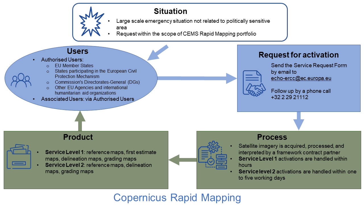
The service can only be activated by Authorized Users. Authorized Users are entities and organizations at National, Regional, European and International levels that are active in the field of crisis management within the EU Member States, the participating States in the European Civil Protection Mechanism, the Commission's Directorates-General (DGs), EU Agencies, the European External Action Service (EEAS), as well as a plethora of international humanitarian aid organizations.
A second entity, referred to as Associated Users, may also benefit from the EMS but are required to go through Authorized Users to trigger the provision of any form of service. Associated Users include local, regional and other public entities, international governmental organizations, national and international non-governmental organizations, EU delegations, and others.
Conditions for Activation
Only large-scale emergency situations, and humanitarian crises caused by disasters of natural origin or man-made emergencies, are within the scope of EMS Rapid-Mapping. The request has to reflect the definition of the service as defined in the product portfolio, which should subsequently then fall within the scope of EMS Rapid-Mapping (e.g. the request to map an entire continent will be rejected). The request should not be related to an existing on-going conflict or crisis with EU military operations, or in politically sensitive areas.
User Request/Point of Contact
Authorized Users may activate the service by sending a Service Request Form (SRF) directly to the Emergency Response Centre (ERCC) of the European Community Humanitarian Office (ECHO) of the European Commission.
There are two activation modes: the Service Level 1, for when the quick provision (within hours or days) of geospatial information in support of emergency management activities immediately following an event, is required.
Conversely, the Service Level 2 is activated when there is a need for the provision of geospatial information of less urgency and for which production will be executed during working days and hours (8.00 - 20.00 local time, Brussels). Authorized Users trigger the mechanism by sending the Service Request Form via email echo-ercc [at] ec.europe.eu.
Every request must be followed up by a telephone call to the ERCC (+32-2-29-21112).
Process
Products are available to the requesting Authorized User free of charge. The generation of space-based information is carried out by framework contract partners.
Products/Information
The Authorized User will receive satellite-derived information that is GIS compatible. The products are standardized and depend on the set of parameters which the user has chosen when placing the service request.
For Service Level 1, there are four categories of products offered: Reference Maps, First Estimate (providing an extremely fast (yet rough) assessment of most affected locations), Delineation Maps (providing an assessment of the geographic extent of the event) and Grading Maps (providing an assessment of the damage grade and its spatial distribution).
For Service Level 2 there are three broad product categories: Reference Maps, Delineation Maps and Grading Maps.
