India

country taxonomy block

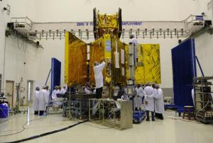
On July 25, 2013 the Indian meteorological satellite INSAT-3D was successfully launched, equipped with search and rescue payload that will facilitate speedy search and rescue operations to India and surrounding regions. These mechanisms on board of the INSAT-3D pick up and relay alert signals originating from the distress beacons of maritime, aviation and land based users and relays them to the mission control centre, improving the emergency response.

Moreover, the satellite carries an atmospheric sounding system that is expected to add a new dimension to weather monitoring with a 6-channel imager and a 19-channel infrared sounder that will provide full disc imagery every 30 minutes over the Indian Ocean and surrounding regions.

INSAT-3D stands for Indian National Satellite - 3D and is part of the INSAT-3 series developed by the Indian Space Research Organisation (ISRO). The satellite was launched by an Ariane-5 launch vehicle from the spaceport of Kourou in French…

more
Publishing date 02/08/2013

From 22 to 26 July 2013, UN-SPIDER jointly with CSSTEAP (Centre for Space Science Technology Education for Asia and the Pacific), IWMI (International Water Management Institute) and UNESCAP organized an international training programme on flood risk mapping, modeling, and assessment using space technology. The training took place on the CSSTEAP premises in Dehradun, India.

Based on observations and recommendations of several technical advisory missions organised under the framework of UN-SPIDER in several countries, this international capacity building programme was conducted with a view of sharing latest developments in using space-based information for flood risk mapping and modelling. A total of 19 participants from 11 countries from Asia and the Pacific region attended the training programme.

The programme included theory lectures and experience sharing by the experts from IWMI, UN-SPIDER, Indian Institute of Remote Sensing (IIRS), Indian Space Research Organisation…

more
Publishing date 29/07/2013

The Indian State is strengthening efforts towards flood mapping using GIS to assess the vulnerability of selected areas and therefore, be able to prepare the necessary disaster mitigation activities to prevent negative impacts of future floods.

“We are currently analysing the spread of water when released from dams", said an official from the State Government, "Suppose one lakh cusecs of water is released, we must know where it will spread and to what extent will it cause flooding. Similarly, we will study the changes when larger volumes are released”.

To this purpose the State Government of Gujarat will launch a pilot trial of its flood mapping project at the Mahi river basin. Once this is completed the flood mapping project will also be implemented for the Tapi, Sabarmati and Damanganga basins. "This is an important step towards mitigating the threat of floods.”

more
Publishing date 24/07/2013

India’s first dedicated navigation satellite, the IRNSS-1A, developed by the Indian Space Research Organisation, was successfully put in orbit on Monday night, as the newspaper The Hindu reported on their website.

The report continues: "The launch vehicle, PSLV-C22, bearing the 1,425-kg navigation satellite, blasted off the launch pad at the Satish Dhawan Space Centre here at the scheduled lift-off time of 11.41 p.m. The IRNSS-1A is the first of the proposed seven satellites in the Indian Regional Navigation Satellite System. Apart from India, its benefits would extend to a range of 1,500 km in the region. With a mission life of 10 years, it will deliver applications ranging across terrestrial, aerial and marine navigation, disaster management, tracking of vehicles, guiding hikers and travellers, and visual-voice navigation for drivers.

Video of the launch

more
Publishing date 02/07/2013

Following severe flooding in northern India and Nepal, the Indian government activated the 'International Charter Space and Major Disasters' on 19 June 2013 at 10:30. The German Aerospace Center (DLR) tasked its radar satellite TerraSAR-X with acquiring images of the affected areas and made these available to the Indian civil protection authorities.

In India, the situation is far worse than first thought. The heavy rains surprised the people in the disaster areas. So far, the floods are known to have killed more than 680 people and thousands are still missing; about ten thousand military personnel have been deployed. The biggest rescue operation in the history of the Indian military is underway. The effects are especially bad in the mountainous state of Uttarakhand, where the Ganges River and its tributaries have flooded. TerraSAR-X has imaged this…

more
Publishing date 28/06/2013

UN-SPIDER's Regional Support Office in Nepal, ICIMOD, published an overview of the events following the heavy monsoon rains this past month in Nepal and India causing heavy flooding. In their brief note, the following questions are addressed: What kind of climatic events led to this disaster? Could anything have been done to reduce the loss of life and property? What can we learn from this disaster for the future? With in-depth figures and facts, the experts look at the Mahakali river flood (transboundary river between Nepal and India), the intense monsoon precipitation levels in Central Nepal, and give an overview of the currently known impact of the floods on lives and properties.

Publishing date 27/06/2013

On 28 May, 2013, the Indian Space Research Organisation unveiled a new Navigation Centre in Bangalore Rural Disctrict, as The Economic Times reported. The new Centre (INC) will serve the proposed Indian Regional Navigation Satellite System (IRNSS), a constellation of seven satellites that will enable users to determine their precise location and time.

The Centre is located at the Indian Deep Space Network complex at Byalalu and will be responsible for the time reference, generation of navigation messages and monitoring and control of ground facilities including ranging stations.

ISRO Chairman K Radhakrishnan said: "INC will host several key technical facilities for supporting these navigation functions and the key to the navigation support is the time reference to which all ground based systems and the satellite clocks are synchronised."

The launch of the first Indian Navigation Satellite IRNSS-1A was originally scheduled for 12 June, 2013…

more
Publishing date 04/06/2013

UN-SPIDER's Regional Support Office, ICIMOD (International Centre for Integrated Mountain Development) and its partner Aaranyak-India are developing and testing the establishment of flood early warning systems in selected rivers of the project area. The project aims to enhance community resilience to water-related hazards in Assam and Arunachal Pradesh and is part of the Himalayan Climate Change Adaptation Programme (HICAP)

To implement the system, ICIMOD has developed a wireless flood early warning system, which wirelessly transmits flood signals to receivers after which it is communicated manually by mobile phones to the concerned people in downstream communities. Nine prototypes were manufactured and tested at Taudaha Lake, located along the southern fringe of the Kathmandu valley. The equipment was manufactured by Sustainable Eco-Engineering with technical support from ICIMOD. Using similar equipments, a prototype of a community based flood early warning system was…

more
Publishing date 30/05/2013

India will soon establish its own GPS-like satellite navigation system. According to the newspaper Times of India the first of seven satellites of the Indian Regional Navigation Satellite System (IRNSS) will be launched in June 2013. This system will provide India with its own data for location and time in all weather conditions.

Times of India cites K Radhakrishnan, chief of the Indian Space Research Organisation IRSO: "The satellite constellation, IRNSS, aims to increase position accuracy and provide standard positioning service for common users and restricted service for authorized users. A space based augmentation system for GPS will make major difference in the way the air ports are operated in India. In the next two years, our country will be blessed with several new satellite based services. Value adding services from use of navigation will also help public."

Two other regions are currently working on establishing their own satnav system as an alternative to…

more
Publishing date 23/04/2013

The Indian Space Research Organization (ISRO) is planning to build Cartosat-3, a satellite capable to take images of the earth with a resolution of 0.25 metres, as TheHindu reported. This remote sensing satellite is expected to exceed GeoEye-1, which is currently the satellite taking the highest resolution images of our planet. GeoEye-1 is capable of taking panchromatic images with a resolution of 0.41 meters. WorldView-2, another satellite operated by the same company, DigitalGlobe, offers a best resolution of 0.46 metres.

In the ‘Notes on Demands for Grants, 2013-2014’ from the Indian Department of Space, which forms part of the budget documents presented to Parliament recently, Cartosat-3 figures as a separate item with an allocation of Rs. 10 crores. “Cartosat-3 is an advanced remote sensing satellite with enhanced resolution of 0.25 metre for cartographic applications and high-resolution mapping,” the document said.

India had launched the…

more
Publishing date 20/03/2013

The UN-affiliated Centre for Space Science and Technology Education in Asia and the Pacific (CSSTEAP) in India has announced its new training course programme 2013-2014 covering the fields of Remote Sensing and GIS, Satellite Communications, Satellite Meteorology and Global Climate and Space and Atmospheric Science. The courses are designed for scientists, engineers and university educators.

The following courses will be offered in 2013 and 2014:

  • Ninth Post Graduate Course on Satellite Communications (SATCOM) from August 1, 2013 to April 30,2014 at SAC, Ahmedabad, India
  • Second International Training Course on Navigation and Satellite Positioning System (NAVSAT) from June 17, 2013 to July 12, 2013 at SAC, Ahmedabad, India
  • International Training Course on Hyperspectral Remote Sensing and its Applications from June 03 to June 28, 2013 at IIRS, Dehradun, India

The details of these courses and the application forms are…

more
Publishing date 25/02/2013

Indo-French space cooperation is all set to soar to new heights with the scheduled launch of a satellite to study changes in the environment soon after the visit of French President Francois Hollande in New Delhi next week.

The SARAL-Altika satellite, a joint project of the space agencies of India and France, will complement the observations of the seas made by current satellites.

Indian Space Research Organisation (ISRO) has identified a launch window between February 22 and February 25 for putting the 450 kg Indo-French satellite into orbit from its spaceport at Sriharikota, official sources said here. India's warhorse rocket, Polar Satellite Launch Vehicle (PSLV) will put the satellite into orbit.

SARAL is short for Satellite with ARgos and ALtiKa, the two main devices on it which have been provided by French space agency CNES. Besides building the spacecraft, ISRO will launch and operate it through its life.

more
Publishing date 14/02/2013

ArcGIS announced that an additional batch of the large set (up to 50 million square kilometers) of high-resolution imagery to be added to the World_Imagery map service is fully processed and published to ArcGIS Online. The World Imagery map was recently updated to include expanded coverage of 1m resolution GeoEye IKONOS imagery for parts of India and Africa. This represents the latest update as additional IKONOS imagery is fully p, rocessed and published.

Publishing date 05/10/2012

The International Charter Space and Major Disasters was activated for a floods and landslides in India and fires in Ecuador.

The Charter for India was acticated by the Indian Disaster Management Support Programme (DMS) on Sunday, 16 September 2012. On Friday, 14 September 2012, a series of cloudbursts had struck the Himalayan state of Uttarkhand, triggering flash floods and landslides. At least 45 people have been killed and 35 others are missing whilst several more are injured. The worst affected areas include several villages: Chunni, Mangoli, Kimana, Sansari, Giriya, Brahmankholi, Premnagar and Juatok. Heavy rains are known to be deadly in this area and will continue until September.

The Charter for Ecuador was activated by Sistema Federal de Emergencies (SIFEM) on behalf of Secretaria Nacional de Gestion de Riesgos (ECUADOR) on Saturday, 15 September 2012. 22 fire fighters were wounded in Ecuador after an arson attack on Tuesday, 11 September 2012. The worst…

more
Publishing date 18/09/2012

SPOT-6, the new high resolution optical Earth observation satellite, built by the European leading space technology company Atrium, will be launched from India next month. . It will provide a wide view over a large area and it will offer enhanced performance compared with its predecessors and it is also lighter. It will have a service life of 10 years.


More information about SPOT 6: http://www.astrium.eads.net/node.php?articleid=8892


more
Publishing date 03/08/2012

The Pune Municipal Corporation (PMC) and the Indian Institute of Tropical Meteorology (IITM) will set up 14 Automatic Weather Station (AWS) within the city limits to monitor monsoon accuracy and flood-like situation. The United Nations Development Programme (UNDP) is funding Rs 10 lakh for the project.

Publishing date 02/08/2012

The International Charter: Space and Major Disasters was activated by the Indian Space Research Organisation (ISRO) on 29 June 2012. Floods, caused by heavy rains over the last two weeks, have taken a toll of 27 human lives in Assam State, India and affected almost one million. The population in 2084 villages in 22 districts have been affected by floods this year. 173 relief camps have been set up so far to provide shelter for those affected.

The Brahmaputra river was reported, on 28th June, as flowing above the danger mark in all its gauge stations at Dibrugarh, Neamatighat, Tezpur, Guwahati, Goalpara and Dhubri, according to the evening flood bulletin of the Central Water Commission. The districts affected by the current wave of flood include Barpeta, Dhemaji, Jorhat, Golaghat, Tinsukia, Dibrugarh, Sivsagar, Nagaon, Morigaon, Lakhimpur, Kokrajhar, Dhubri, Nalbari, Bongaigaon, Chirang, Baksa, Sonitpur,…

more
Publishing date 02/07/2012

The National Institute of Disaster Management (NIDM) of India published the e-book "Ecosystem Approach to Disaster Risk Reduction", which is freely available on the UN-SPIDER Knowledge Portal.

The publication focuses on the importance of protecting and improving ecosystems for reducing disaster risk. It gives general introductions to the topic of Eco-Disaster Risk Reduction and showcases specific issues such as coastal hazard mitigation, landslide risk, urban flood risk or fire management. Furthermore, it indicates practical strategies and tools to better include ecological approaches into disaster risk reduction.

NIDM is one of UN-SPIDER's partners in conducting its Capacity Building activities. UN-SPIDER and NIDM had jointly supported the training workshop on "Space technology applications in disaster management and emergency response" in New Delhi,…

more
Publishing date 23/05/2012

On 26 April 2012, the Indian Space Research Organisation (ISRO) successfully launched their first indigenously built all-weather Radar Imaging Satellite, RISAT-1. RISAT-1, weighing 1,858 kg and being the heaviest satellite launched yet by the carrier PSLV, is an Active Microwave Remote Sensing Satellite carrying a Synthetic Aperture Radar (SAR) that will operate in the C-band. This means that RISAT-1 can send imagery of earth's surface at day and night and under any weather conditions. Orbiting earth in 536 km height in a daily routine of 14 orbits with a repetitive cycle of 25 days, the satellite is a very valuable resource for space-based information for disaster response and disaster risk management. RISAT-1 has an expected mission life of five years. ISRO Chairman K. Radhakrishnan called the launch a "grand success".

Publishing date 02/05/2012

On 9 April 2012 UN-SPIDER inaugurated the international training course “Space technology applications in Disaster Risk Reduction” organised at the Centre for Space Science Technology Education for Asia and the Pacific (CSSTEAP), the UN affiliated regional centre based in Dehradun, India. The Course will be conducted until 4 May 2012. During the first two days of the course, UN-SPIDER provided a brief overview on relevance of space technology for implementing priorities of Hyogo Framework for Action and addressed the topic related to effective use of space technology for disaster risk reduction.

The course is jointly conducted by the Indian Institute of Remote Sensing of ISRO, UN-SPIDER, UNESCAP and UNU. UN-SPIDER sponsored 5 officials from Bangladesh, Sri Lanka, Myanmar and Solomon Island. This was the follow-up action after the recent technical advisory missions carried out by the UN-SPIDER in Bangladesh, Sri Lanka and Myanmar. A total of 27 participants from 17…

more
Publishing date 17/04/2012

UN-SPIDER and National Disaster Management Authority (NDMA) of India jointly supported a training workshop on "Space technology applications in disaster management and emergency response" at New Delhi India. The workshop was organised by the National Institute of Disaster Management (NIDM). The event provided a platform to the State Disaster Management Authorities and providers of space based information (State Remote Sensing Applications Centres, National Remote Sensing Centres of Indian Space Research Organisation) to discuss latest systems, tools, technologies, products and best practices.

UN-SPIDER designed the programme with help of NIDM, NDMA supported the programme by inviting the appropriate nominations. The programme was hosted at NIDM. It brought together 25 key participants and resources persons. The resources persons provided latest trends in disaster risk reduction and space technology interventions. The participants shared best practices and also…

more
Publishing date 13/04/2012

The first of India's own little regional positioning satellites to better the US military-owned GPS may be put up in sky this year. The seven-satellite constellation, called the Indian Regional Navigational Satellite System, when fully in place over the coming years, will be far more accurate than the GPS that the world depends on. It would be available to users in the sub-continent all the time come rain or shine, according to ISRO. The space agency along with its other government partners on Wednesday briefed 250 current and potential users, planners, industry and scientists on the uses of navigational systems. The Airports Authority of India co-sponsored the first Global Navigation Satellite System (GNSS) meet. ISRO's Director, Publicity and PR, Mr S.Satish, said GPS signals and position data received in the country are often wide of the mark. “When we have our own IRNSS, it will be equal to, if not better than, the GPS.” An ISRO release said, “The regional…

more
Publishing date 24/02/2012

India must embark on a “new evergreen revolution” with the extensive use of appropriate bio- and space technology inputs to ensure food security for all and enable the country to compete successfully in a globalised economy, says renowned space scientist U.R. Rao. India’s population is bound to cross 1.6 billion by 2050, which will demand doubling of our foodgrain production to ensure food security to all our people, according to him. And in the past one decade, India’s agricultural production has remained stagnant between 220 and 240 million tonnes. Agricultural productivity (1.8 tonne per hectare) is much less than the world productivity of 2.6 tonne per hectare. The solution, the former chairman of the Indian Space Research Organisation (ISRO) said, lay in the application of science and technology.

Rao was a member of an expert committee headed by economist A. Vaidyanathan which in a recent report to the agriculture ministry suggested using remote…

more
Publishing date 21/02/2012

National Disaster Management Guidelines for Information and Communication System (NDMICS) prepared by National Disaster Management authority (NDMA) were released in New Delhi today. Speaking at the occasion, Shri M. Shashidhar Reddy, Vice Chairman, NDMA stressed that the holistic approach for Disaster Management calls for a dedicated fail-proof communication system to ensure seamless flow of value-added information products on GIS platform not only in the response phase but also for prevention, preparedness, mitigation and recovery, besides capacity building programmes. Shri Reddy informed that to achieve this, it is contemplated to establish National Disaster Management Information System (NDMIS) at the central level (with a disaster recovery system at a safe location) that would be coupled to a dedicated and fail-safe National Disaster Communication Network (NDCN) with particular emphasis on last-mile connectivity.

NDCN will be network of networks by leveraging existing…

more
Publishing date 21/02/2012

[NEW DELHI] Combining remote sensing technology with water and soil conservation techniques can help raise crop yields in South Asia, scientists have reported.

Satellite data can help identify specific problems on farmlands such as moisture shortage, excessive soil wetness and flood occurrence.

Using the data along with appropriate resource conserving technology (RCT) will increase productivity, a study team of researchers reported this month (8 September) in Applied Geography.

The study team included researchers from the International Rice Research Institute (IRRI), Manila, International Maize and Wheat Improvement Centre, Banaras Hindu University, Jawaharlal Nehru University, Delhi, and Punjab state’s department of agriculture.

Applied in the Balia district of northern Uttar Pradesh state, the method showed significant increase in annual per hectare incomes — US$ 63 by raising beds in saline soils, US$ 140 by introducing deep-water rice…

more
Publishing date 05/10/2011