Italy

country taxonomy block

The European Commission plans to rapidly expand its environmental monitoring programme Copernicus. For this purpose, the European Space Agency (ESA) recently pledged 2.55 billion Euros towards contracts to advance the production of six new Copernicus satellite missions. The final of the six contracts was signed last Thursday between ESA and Thales Alenia Space for a mission that will provide new and important information to climate research and disaster management.

The high-priority Copernicus Radar Observation System for Europe in L-band (ROSE-L) mission is planned to launch in 2028 for a period of 7.5 years. The ROSE-L mission will orbit Earth every few days at an altitude of 690km and will carry a L-Band synthetic aperture radar (SAR). With a wavelength of approximately 23cm, an…

more
Publishing date 18/12/2020

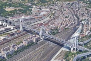
Evaluating the safety and integrity of infrastructure such as bridges, which is often done through hands-on inspections, may soon be possible with the help of information captured several kilometers above the Earth’s surface. According to a National Aeronautics and Space Administration (NASA) news article, scientists from NASA, the University of Bath, and the Italian Space Agency used historical synthetic aperture radar (SAR) satellite imagery to study the condition of the Morandi Bridge near Genoa, Italy, in the 15 years prior to its August 2018 collapse, which claimed the lives of dozens. 

Evaluating satellite data using the techniques of SAR multi-temporal interferometric analysis (MT-InSAR) and Markov Chain Monte Carlo…

more
Publishing date 08/07/2019

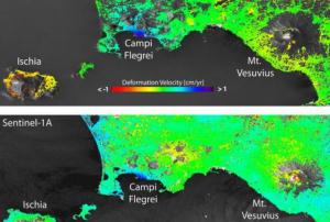
The lowering or sinking of the ground’s surface, referred to as land subsidence, can cause serious damage to infrastructure and private property, and in turn, have an adverse impact on communities, individuals, and the economy. The European Space Agency’s (ESA) Sentinel-1 satellite, part of the Copernicus programme, is being used to monitor cases of land subsidence and contribute to risk assessment and urban development efforts.

From Sentinel-1 radar data collected over time, ground deformation maps can be created, which provide important insights to local authorities charged with implementing hazard mitigation and management strategies. For example, such maps recently helped authorities in…

more
Publishing date 30/05/2019

A one-week-long event brought together scientists and users to present their latest findings on the Earth’s environment and climate derived from satellite data. Organized by the European Space Agency (ESA), the Living Planet Symposium also introduced ESA missions – such as the Sentinels, Earth Explorers and meteorological missions – as well as national missions in development.

The event took place in Milan, from 13 to 17 May 2019, and offered an opportunity to hear first-hand from scientists about recent environmental discoveries, the latest facts on climate change and how state-of-the-art satellites and novel measuring techniques from space are taking the pulse of our planet.

The week was packed with sessions and talks about observing Earth from space. A special emphasis was put on how information from space is critical for international bodies assessing climate change and implementing strategies to address societal issues such as air…

more
Publishing date 21/05/2019

On 21 March in French Guiana, the Italian remote sensing satellite PRISMA launched aboard a Vega rocket of European launch provider Arianespace. Data from the satellite will be used for natural disaster prevention and disaster response, among other purposes.

The satellite was designed for Italian researchers and will serve as a prototype for future missions. With PRISMA’s images, scientist will study environmental behavior, including climate- and other human-influenced changes. Besides disaster management the data will be applicable for monitoring water pollution and agriculture, land use, soil mixtures as well as the carbon cycle.

PRISMA, or “Precursore Iperspettrale della Missione Applicativa”, which translates into “hyperspectral precursor of the application mission”, is a small hyperspectral imaging satellite.

It has been constructed by space company OHB Italia…

more
Publishing date 08/04/2019

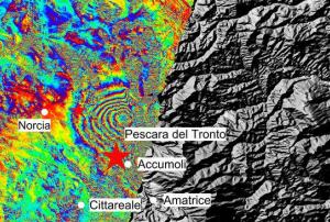
Scientists analysis of radar scans from satellites provides new data on the consequences of the earthquake that affected the central part of Italy on October 30th.

Italian experts have used radar imagery from Copernicus Sentinel-1 satellites to detect considerable east-west and vertical displacements of the ground in areas like Montegallo, Norcia and Castelluccio.

Combining radar scans prior and subsequent to the seismic activity the scientists from the Institute for Electromagnetic Sensing of the Environment of the National Research Council and the National Institute of Geophysics and Volcanology have mapped modifications that are between 12 and 60 in a centimeter-scale.  

The team of scientists have benefited from satellite imagery provided by Sentinel-1 satellites of Europe’s Coeprnicus programme led by the European Commission and operated by ESA; the Cosmo-SkyMed satellite from the Italian space agency  and information from other…

more
Publishing date 12/11/2016

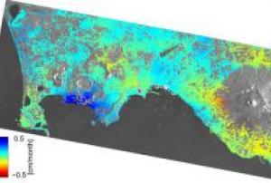
The remote sensing technique to map ground deformation is being improved thanks to scientific work based on frequent observations from the Sentinel-1A radar satellite data.

The one-year old satellite data has been compared with those from the ERS and Envisat, former satellite radar missions. This work has enabled researchers of Italy’s Institute for Electromagnetic Sensing of the Environment (IREA-CNR) to show a drastic improvement in mapping surface deformation and to draw a new path for earthquake and volcano monitoring.

“To achieve this, the scientists used the Interferometric Synthetic Aperture Radar, or InSAR, technique. This involves combining two or more radar images acquired at different times. If something on the ground has changed between the acquisitions, the terrain deformation is displayed as a continuous sequence of coloured stripes called interference fringes, or an ‘interferogram’,” explains the European Space Agency on…

more
Publishing date 09/06/2015

Earth’s changing surface can be closely monitored thanks to the use of satellite radar data. This week at the Fringe Workshop held by the European Space Agency ESA, new advances in the science and applications of Interferometric Synthetic Aperture Radar (InSAR) were presented.

InSAR is a remote sensing technique where two or more images of the same area are combined to detect slight changes occurring between acquisitions. ESA elaborated: "Tiny changes on the ground cause changes in the radar signal and lead to rainbow-coloured interference patterns in the combined image, known as an ‘interferogram’. Small movements – down to a scale of a few millimetres – can be detected across wide areas. Tectonic plates grinding past one another, the slow ‘breathing’ of active volcanoes, the slight sagging of a city street through groundwater extraction, and even the thermal expansion of a building on a sunny day."

A study realised…

more
Publishing date 26/03/2015

The European Commission has awarded a contract worth 12 million Euros to e-GEOS, to provide satellite maps for emergency management. The contract, identified as Copernicus Emergency Management Service – Rapid Mapping, will be active in the period 2015- 2019.

e-GEOS, a company established by Telespazio (80%) and the Italian Space Agency (20%), will lead an international consortium formed by the German subsidiary GAF, the German Aerospace Center (DLR), the Italian company Ithaca and the French partners Sirs and Sertit. Under the new contract, the consortium will prepare and make available to the European Commission, in a short time after the activation of the service by the authorized user, satellite maps of areas affected by a natural disaster or humanitarian crisis.

To facilitate the damage assessment and the assistance intervention management, the European Commission makes available…

more
Publishing date 04/03/2015

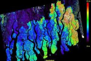
More than 275 researchers from around the world gathered last week at the biennial POLinSAR and first Biomass science workshops hosted at ESA’s centre for Earth observation in Frascati, Italy. Polarimetric InSAR – or POLinSAR – is a remote sensing technique based on combining polarimetric and interferometric information in synthetic aperture radar images.

ESA reported: "One of the examples presented at the POLinSAR gathering shows how the height of Bangladeshi mangrove forest, which is an important local resource, can be mapped from space. This example uses data from the German TanDEM-X satellite along with POLinSAR." The technique of POLinSAR has matured considerably over recent years and scientists are now looking forward to further advances that will come once ESA’s Biomass mission is launched 2020.

Publishing date 02/02/2015

Data collected by satellite has been used to establish the stability of the ground sustaining the Basilica di Massenzio in Rome, the largest of the ancient buildings that make up the Roman Forum. ESA explains on their website: "With the help of the satellite images, the geologists could tell very quickly if a particular hillside had slid a little over the years, or if the ground under a house had sunk a bit.

In order to measure if the vibrations coming from the modern-day Roman traffic and expansion of Rome's metro line was affecting the stability of the building, geologists and engineers made use of satellite images collected by Earth observation missions like ERS and Evnisat. The images were used to determine if there had been any movement of the ground beneath the structure.

Previously, when they suspected any movement of the ground, experts had to wait several months to confirm or discard their suspicions. With the new technique experts were able to measure…

more
Publishing date 04/12/2014

Flood is one of the most common geohazards, which also costs most devastation to society. There are areas more vulnerable to floods, where measures are taken to mitigate the impacts, but further research is needed for identifying flood vulnerability in order to make communities in such vulnerable areas more resilient.

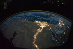
Professor Alberto Montanari from the University of Bologna found new ways of pinpointing vulnerable areas by using satellite observation of night time lights from homes or businesses and combining this data with river network data.

The Institute of Hazard, Risk and Resilience explains: "Since night lights are a useful indicator for human settlements it can be used to identify and prioritise vulnerable populations that live close to streams or rivers. The data presented by Montanari shows an increase in night lights in…

more
Publishing date 19/03/2014

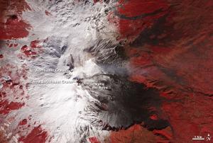
On January 22 2014 , the NASA satellite Terra captured an image of the volcano on Mount Edna in Italy diffusing a plume of gas and ash.  An eruption is expected in the next couple of days.

The false color image made by the Advanced Spaceborne Thermal Emission and Reflection Radiometer (ASTER) on Terra combines near infrared, red and green light. Snow in this image is white, lava (up to 100 years old) appears black and dark brown and vegetation is red. Volcanic plume is light grey.

more
Publishing date 29/01/2014

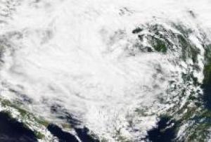
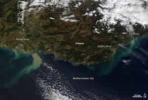
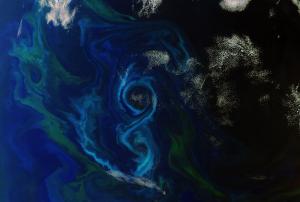
Heavy rainfall caused flooding in southeastern France and northern Italy. On the images taken by the MODIS sensor on NASA’s Terra satellite, the mud-laden runoff is clearly visible creating tan and green plumes of sediment in the Mediterranean.

The floods caused two deaths and forced widespread evacuation. BBC reported on the situation in France: “By Sunday evening, 155 people had been airlifted from the worst-hit areas and the evacuation of residents by boat was continuing.” In Italy, the regions around Bologna, Genoa and Florence experienced widespread flooding, with the city of Modena, in the Emilia-Romagna region, particularly affected.

more
Publishing date 27/01/2014

The first Sentinel-3 Validation Team workshop was recently held at ESA’s centre for Earth observation in Frascati, Italy, validating Sentinel-3 data in order to allow to verify their performance once the mission is in orbit. The workshop was a significant step in the mission’s validation programme, held as a four-day event and organised in partnership with Eumetsat, which will operate the satellites and generate all marine data products.The validation activities on Sentinel-3 are currently led by over 100 Principal Investigators, with an additional 400 co-investigators, from across the world.

The Sentinels missions are designed to meet the needs of Europe’s Copernicus programme, providing essential information to the understanding of our planet and the evolution of Earth’s climate. Sentinel-3 mission consists mainly on measuring sea-surface topography, sea - and land - surface temperature and ocean - and land - surface colour. The obtained information will be used for…

more
Publishing date 11/12/2013

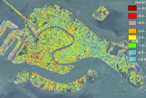
Researchers at the University of Padua, Italy, have found satellite-based evidence that the city of Venice keeps sinking. In their article titled "Natural versus anthropogenic subsidence of Venice", Pietro Teatini and his colleagues explain: "During the last two decades, satellites instrumented with SAR (Synthetic Aperture Radar) sensors provided excellent data for detecting land displacements by interferometric processing. The use of this methodology opens new possibilities for a more accurate interpretation of the land subsidence."

Teatini, a hydraulic engineer, said according to Livescience: "Venice is in a situation so critical with respect to the sea that continuous monitoring of the city's movement is of paramount importance."…

more
Publishing date 02/10/2013

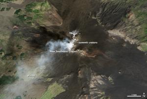
Sicily’s massive Etna Volcano is again showing signs of life after a 4 month pause, as NASA Earth Observatory is reporting. "Beginning on September 3, 2013, the Osservatorio Etneo (Etna Observatory) observed explosions and puffs of ash at the summit craters and New Southeast Crater. Over the next few weeks explosions became more frequent. Boris Behncke, a volcanologist at the Osservatorio Etneo captured photographs of ash plumes on September 23 and 25."

NASA's Landsat 8 captured an image of Etna's activities on 24 September 2013 showing a plume of what probably are volcanic gases moving in a southwestern direction.

Publishing date 01/10/2013

UNOOSA/UN-SPIDER participated as a trainee and observer in the Project Manager (PM) training for the International Charter Space and Major Disasters. The two day training course on 27 and 28 June 2013 offered sessions on the objectives and processes of the Charter and others on the specific roles of Project Managers. Demonstration and simulation exercises allowed the trainees to learn the whole process of coordinating activation and of providing adequate products to end users and authorized users of the Charter.

UN-SPIDER's Regional Support Offices in Algeria, Hungary, Iran and Romania as well as the regional centre ICIMOD also participated in the training. OOSA is a partner of the International Charter and is committed to promote and facilitate the implementation of its Universal Access Initiative.

The Project Managers play an important role in the Charter's internal processes. In the case of an activation, he coordinates the call from request to delivery by…

more
Publishing date 02/07/2013
After the workshop the German Space Agency (DLR) has organized in September 2011, the Joint Research Centre (JCR) hosted a follow-up meeting in Ispra in April 2012, during which the International Working Group on Satellite Based Emergency Mapping (IWG-SEM) was officially established.
 
Over the last decade, the use of earth observation satellites has become more and more important to support disaster management and emergency relief, with an increasing number of players involved from governments, academia, industry, NGOs and internet communities. Taking into account this matter, IWEG-SEM was created with the following mission statement:
 
'Establish best practices between operational satellite-based emergency mapping programs to stimulate communication and collaboration to include definition of map product generation guidelines, coordination of expertise and capacities, building of training curriculum, participation in…
more
Publishing date 08/06/2012

e-GEOS has won two tenders launched by the European Commission worth a total of EUR 9.6 million, as part of the GMES (Global Monitoring for Environment and Security) programme. e-GEOS, will provide geospatial information and satellite maps of areas affected by emergencies to the European Commission, which will then be able to make the data necessary to manage disasters available to the civil protection services and competent authorities of EU countries. Furthermore, the Commission will be able to make pre- and post-event maps of any area in the world available within a few hours of the emergency arising, thereby facilitating the organisation of aid operations. The 24-hour-a-day service can be used in all crisis situations (floods, earthquakes, fires, technological disasters, etc), and will be managed by e-GEOS, which will lead a consortium consisting of German subsidiary GAF, Italian company Ithaca and French group SIRS. The two contracts concern "rush" and…

more
Publishing date 29/02/2012

Under the authority of the European Commission’s Joint Research Centre (JRC) and in collaboration with the European Space Agency (ESA), the Institute for the Protection and Security of the Citizen (IPSC) has produced the first prototype of the Global Human Settlement Layer (GHSL) using European medium resolution ENVISAT ASAR satellite data and advanced pattern recognition algorithms developed by the JRC.

The GHSL is expected to benefit many applications, such as disaster risk reduction, post-disaster humanitarian relief and regular monitoring of changes in human settlement patterns and extent. During 2011, the JRC will complete the first ever finer detail global human settlement layer based on European ENVISAT ASAR data.

All the crisis management cycle - including damage assessment, recovery, reconstruction and planning should benefit from an improved and globally-consistent description of human…

more
Publishing date 01/03/2011

Conference Theme: Remote Sensing And Geo-Information For Environmental Emergencies

Geomatics technologies are able to support management and recovery in the aftermath of manmade and natural disasters. However, disaster management also poses big challenges in all aspects of the geo-information cycle, from data acquisition, processing, management and delivery. For the sixth time, the International Symposium on Geo-information for Disaster Management (Gi4DM) brings together researchers, developers, data providers and users from all over the world to discuss these challenges.
Papers that deal with any aspect of geomatics technologies suitable for crisis management are invited. Authors should focus on the methodologies, tools, functionality, and/or interfaces that are being or should be provided to National and/or International Organizations involved with crisis response and management. Invitation is also open for contributions that cover crisis management in any phase,…

more
Publishing date 25/07/2009

As well as providing critical information about ice, CryoSat has also demonstrated that it can offer a valuable source of data for oceanography, hydrology and geodesy.

The conference therefore provides a forum for international scientists and operational users to present and share state-of-the-art CryoSat-based results, its decadal contribution to science and future perspectives in the following areas:

  • Sea ice
  • Greenland and Antarctica icesheets
  • Glaciers and ice caps
  • Oceans and marine gravity
  • Hydrology
  • Icebergs & ice shelves
  • 10 Years of operations, synergies and future missions
more

The European Space Agency, in the context of the "Earth Observations Science for Society" Programme, and CNES are organising a sequel event to Hydrospace2015, called 4th Space for Hydrology Workshop - "Inland Water Storage and Runoff: Modeling, In Situ Data and Remote Sensing", Monday 7 - Friday 11 June 2021, hosted at ESA-ESRIN, Frascati, Italy. This time around the Hydrospace Workshop is organised in collaboration with the GEO Global Water Sustainability Initiative (GEOGloWS) - see the Objectives page - looking for opportunities to explore joint solutions with a broader view on key science questions for Research and Development, up to Operational use of remote sensing information. The aim of getting together during 4~4.5 days is to strengthen the collaboration between the four critical water communities: in situ, modelling and space observation scientists as well as “non-scientific” users such as water managers to address the needs of the application community.

more

The 6th World Landslide Forum “Landslides Science for sustainable development” will be held in Florence at the Palazzo dei Congressi from 14 to 17 November 2023.

The event, jointly organized by the International Consortium on Landslides (Kyoto, Japan), the International Programme on Landslides (IPL) and the UNESCO Chair on Prevention and Sustainable Management of Geo-hydrological Hazards at the University of Florence, will focus on Landslide Science for Sustainable Development, as a contribution to the Kyoto 2020 Commitment for global promotion of understanding and reducing landslide disaster risk (KLC2020).

The forum will focus on the following themes, among others:

  • The Kyoto Landslide Commitment for sustainable development
  • Remote…
more