English
Español
Français
Search form
Search
Menu
Main menu
Home
Space Application
Emergency Mechanisms
Space Application Matrix
Satellite Technology
Space Technologies in the UN
User Stories
Risks & Disasters
Disaster Risk Management
Emergency and Disaster Management
The UN and Disaster Risk Management
The UN and Disaster Management
The Sendai Framework for Disaster Risk Reduction
Natural Hazards
Links & Resources
Countries
Institutions
Data Application of the Month
Data Sources
GIS and Remote Sensing Software
External In Person Training Opportunities
External Online Training Opportunities
Advisory Support
Advisory Missions
Emergency Support
Recommended Practices
Training Activities
Network
GP-STAR
IWG-SEM
MHEWS
National Focal Points
Regional Support Offices
Projects
EvIDENz
SEWS-D
News & Events
Events Calendar
Monthly Updates
Newsletter
News
UN-SPIDER Events Archive
About Us
What is UN-SPIDER?
About UNOOSA
Publications
Jobs
Contact
Meet the team
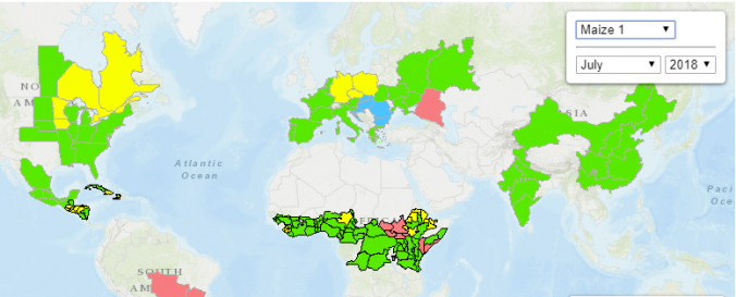
Crop monitoring - GEOGLAM (GEO)
Data provided by:
United States Geological Survey (USGS)
Data accessibility:
export data, visualization of data (e.g. web GIS or real time monitoring)
Link to the data:
GEOGLAM Landsat data for Ethiopia, Algeria, Argentina, Australia,Pakistan, Russia, Uganda, and Ukraine (via Earth Explorer)
MODIS GLAM NDVIDB (University of Maryland)
GEOGLAM crop monitor (monthly reports and charts, assessment tool)
FAO's Agriculture Market Information System (AMIS) based on GEOGLAM crop monitor
Requirements:
Registration and login.
Here
you go
File type:
jpeg
,
tiff
Data type:
hazard specific data
Hazard:
Drought
Disaster cycle phase:
Disaster Risk Management
Satellites and Sensors:
Landsat 8
,
Aqua
,
Terra
Spatial coverage:
Global
Spatial resolution:
30 - 100
Temporal coverage:
Archive, Near-real time
Content dates:
1999 - today
Technical Specifications:
GEO Global Agricultural Monitoring (GEOGLAM) - website
Costs:
free
Contact:
Michel Deshayes (mdeshayes [at] geosec [dot] org
Tutorials on the use of data:
Recommended Practice by ISA on using MODIS GLAM NDVIDB for drought monitoring
,
How to download GEOGLAM data from Earth Explorer
Restrictions/ Citation of the dataset:
Privacy policy
Log in
to post comments
Provider
Leave this field blank
Share this page
Share on Facebook
Twitter
Linkedin Share Button
Zircon - This is a contributing Drupal Theme
Design by
WeebPal
.