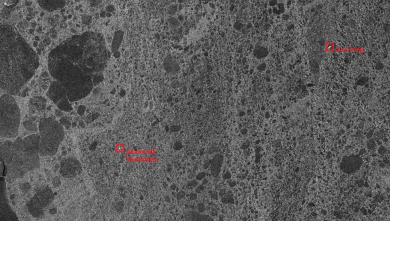
The Russian research vessel Akademik Shokalskiy was trapped for over a week in the Antarctic ice. High-resolution radar satellite data provided by the German Aerospace Center (DLR) helped to assess the conditions at the location and develop a rescue plan. In pack ice, conditions can change fast due to change in winds and air conditions. For this reason the German researchers used up-to-date, high-resolution images from the Earth Observation satellite TerraSAR-X, which they provided to the team of the trapped vessel and the rescue mission participants.
The DLR ground station analyzed the received images in near real time and provided them to the rescue center in Australia, one hour after receiving the images. Using the satellite images, the researchers were able to gather information about the thickness and properties of the ice surrounding the vessel. This helped to find appropriate ways for icebreakers to get to the trapped Akademik Shokalskiy.
The German TerraSAR-X radar satellite operates in a variety of modes to permit imaging with varying swathe widths, resolutions and polarisations. It is able to see through clouds and darkness, and map the ocean and frozen waters. To do this, it emits microwaves that are reflected back to the satellite in a way that depends on the characteristics of the reflecting surface, this results in high resolution of down to three meters imagery.

