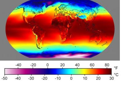
NASA has released a dataset displaying how temperatures and precipitations might change by the year 2100 taking into account various greenhouse gas emission scenarios. This 25-km high resolution data is of free access to the public and shows estimated maximum and minimum temperatures as well as precipitations on a daily basis and at a local and global scale from 1950 to 2100 under two different greenhouse gas emission scenarios: a “business as usual” scenario based on current trends and an “extreme case” with huge carbon dioxide increases. These simulations were carried out by the international Fifth Coupled Model Intercomparison Project.
These maps could contribute to the improvement of climate risk evaluations to get a better knowledge of local and global impacts and risks, such as severe drought, floods, heat waves and losses in agriculture productivity.
This dataset is the newest product by the big-data platform NASA Earth Exchange (NEX), located in NASA’s Advanced Supercomputing Center at the agency's Ames Research Center, California. NEX data can be accessed through the Open NEX project on Amazon Web Services and is a partnership between NASA and Amazon, Inc., to improve public access to climate data, and planning to increase climate resilience both in the U.S. and internationally. OpenNEX is an extension of the NASA Earth Exchange in a public cloud-computing environment.
If you want to learn more about this climate dataset projections, visit https://nex.nasa.gov/nex/projects/1356/. Furthermore, you can get access to the data set at https://cds.nccs.nasa.gov/nex-gddp/

