Five years ago, the National Aeronautics and Space Administration (NASA) and the Japan Aerospace Exploration Agency (JAXA) launched the Global Precipitation Measurement (GPM) Core Observatory as a joint satellite. Since then, the instruments on GPM have provided advanced measurements about rain and snow particles within clouds, Earth’s precipitation patterns, extreme weather and precipitation that affects communities around the world.
GPM was engineered to get data to scientists, operational and application users as soon as possible for societal benefits. It obtains data quickly using the Tracking and Data Relay Satellite (TDRS) 12-member satellite constellation, which serves as an information pipeline between Earth-orbiting satellites and NASA ground stations. On average, GPM can take one to three hours to get data into users’ hands, but in emergencies, the average delivery time can be shortened to between 15 and 90 minutes.
GPM’s main data source is the Core Observatory, but the mission also receives data from the GPM Constellation, which consist of satellites with microwave sensors from the United States, Japan, India and Europe. Most of these satellites have unique objectives and oversight agencies, but by sharing their microwave data with GPM, they expand the mission’s global coverage and consistency.
On the occasion of GPM’s fifth anniversary, we highlight two of the most relevant example regarding disaster risk management, as made possible by measurements taken by GPM.
Forecasting fire
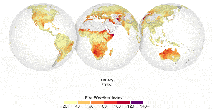
Precipitation can drastically affect the spread of a fire. For instance, if a region has not received normal precipitation for weeks or months, the vegetation might be drier and more prone to catching fire.
NASA researchers have created a model that analyzes various weather factors that lead to the formation and spread of fires. The Global Fire Weather Database (GFWED) is the first fire prediction model to include satellite-based precipitation measurements. Analyzing factors such as local winds, temperatures and humidity, the model produces a rating that indicates how likely and intense fire might become in a particular area.
Also, historical data is available to understand the weather conditions under which fires have occurred in the past, and near–real–time data is available to measure current fire danger.
Automatically detecting landslides
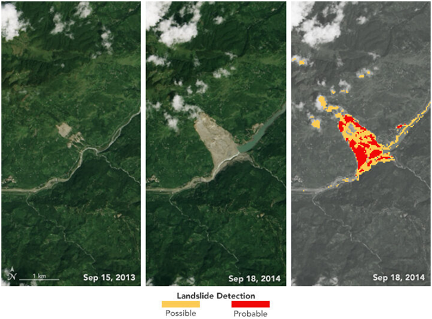
GPM data also plays a key role in building disaster prediction models, such as the Landslide Hazard Assessment Model for Situational Awareness (LHASA), which warns about imminent landslides based on heavy rainfall data.
NASA researchers have designed an automated system to identify potential landslides that might otherwise go undetected and unreported. This information could significantly improve landslide inventories, leading to better risk management.
The computer program works by scanning satellite imagery for signs that a landslide may have occurred recently, looking at topographical features such as hill slopes.
The program also uses data from GPM to help pin when each landslide occurred. The GPM core satellite measures rain and snow several times daily, allowing researchers to create the so-called Detecting Real-time Increased Precipitation (DRIP), a map of maps of rain accumulation over twenty-four hour periods for given areas of interest. When a certain amount of rain has fallen in a region, an email can be sent to emergency responders and other interested parties.