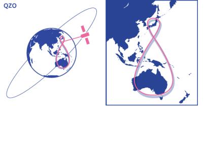
The Japanese national newspaper Yomiuri Shimbun reported on 22 July 2014 that a full-scale operation of Quasi-Zenith satellites is projected to start in 2018, after that a first one, Michibiki, was launched in September 2010.
The Quasi Zenith Satellite System (QZSS) consists of multiple satellites that fly in an orbit passing through the near zenith over Japan. "Satellites on quasi-zenith orbits have a slower speed in the northern hemisphere by moving away from the earth, and a faster speed in the southern hemisphere by coming closer to the earth," as the QZSS website points out. The quasi-zenith orbit "is a figure-eight shaped orbit with north-south asymmetry. Satellites spend approximately 13 hours in the northern hemisphere and roughly 11 hours in the southern hemisphere, allowing them to remain near Japan for a long period of time."
The satellites provide data for the monitoring of earth and mud movement on slopes, allowing to proactively release evacuation information. This system is an updated disaster prevention and evacuation system stemming from a partnership between the Japan Aerospace Exploration Agency (JAXA), Japan’s Cabinet Office and Japan's Internal Affairs and Communications Industry.
The project could also improve Japan's Global Positioning System by providing a higher accuracy - pinpointing a site to within several centimeters. The Japanese government is also considering to establish the nation’s own global positioning system with 10 times the accuracy of the current system.

