• English
  • Español
  • Français

United
Nations


Office for Outer Space Affairs
UN-SPIDER Knowledge Portal

  • Home
  • About Us
    • What is UN-SPIDER?
    • About UNOOSA
    • Publications
    • Jobs
    • Meet the Team
    • Contact
  • Space Application
    • Satellite Technology
    • Emergency Mechanisms
    • Recovery Mechanisms
    • International Asteroid Warning Network
    • Space Mission Planning Advisory Group
    • International Space Weather Initiative
    • Space Technologies in the UN
    • User Stories
  • Links & Resources
    • Data Applications
      • Disaster Recovery
    • Data Sources
    • GIS and Remote Sensing Software
    • Online Learning Resources
    • Institutions
  • Risks & Disasters
    • Disaster Risk Management
    • Early Warning Systems
    • Emergency and Disaster Management
    • Natural Hazards
    • Sendai Framework
    • The UN and Disaster Risk Management
    • The UN and Early Warning
    • The UN and Disaster Management
  • Advisory Support
    • Advisory Missions
    • Emergency Support
    • Virtual Advisory Support
    • Recommended Practices
    • Training Activities
    • Practical Uses
  • Network
    • Regional Support Offices
    • GP-STAR
    • MHEWS
    • IWG-SEM
  • Projects
    • SPEAR
    • SEWS-D
    • EvIDENz
    • Flood GUIDE
  • News & Events
    • News
    • Events Calendar
    • UN-SPIDER Events Archive

Breadcrumb

  • Home
  • News and Events
  • View Active News
  • NOAA: Interactive Storm Surge Map For Flood Risks
  • NOAA: Interactive storm surge map for flood risks

NOAA: Interactive storm surge map for flood risks

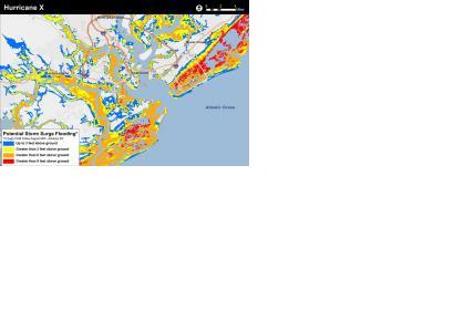
Static example of the experimental potential storm surge inundation map (Image: NOAA)Static example of the experimental potential storm surge inundation map (Image: NOAA)

The National Oceanic and Atmospheric Administration (NOAA) is preparing a new application to help people determine at a street-level where water could rise in a storm surge.

This experimental storm surge simulator will let people get a look at what kind of storm surges can take place in their surroundings and which can be the possible damages. The preliminary model is based on Charleston (South Carolina), USA.

"Surveys of the public show there is still a consistent misunderstanding of what the storm surge is, and how deadly it can be. In part this is due to the challenge scientists encounter in trying to simplify the complex physics of hurricanes for the public, and in part this is due to poor misunderstanding of flood zone maps that represent the flooding scenario as it might be viewed from above," reads the introduction to the app, according to Emergency Management.

Since the feature is still on trial phase, user are called to take a survey before and after using the simulator to help the NOAA’s National Weather Service determine its effectiveness.
Emergency Management
Mon, 13 Apr 2015 - 16:51
Global
United States of America

Footer menu

  • Contact
  • Terms of Use

User account menu

  • Log in