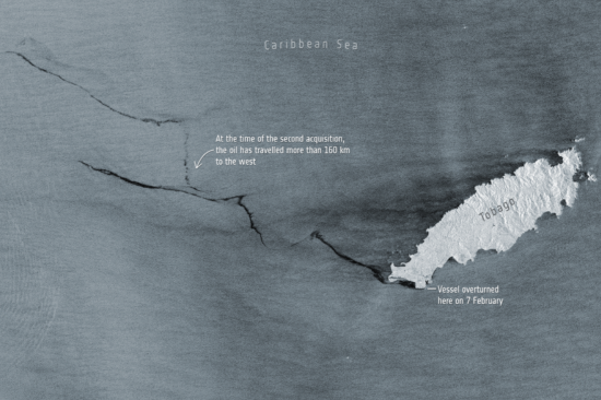
On the 7th of February 2024, a vessel in proximity to Tobago’s southern coastline was found to be capsized and leaking oil into the sea. While local authorities continue to deal with the ongoing issue, satellite imagery shows how this oil spill is progressing. Using satellite radar imagery gathered from the Copernicus Sentinel-1 mission and processed by the ESA, we can see how far the oil spill has traveled thus far. As of the 14th of February, the imagery shows that the oil spill has spread for more than 160 km westward, and may affect neighboring Grenada and Venezuela.
This is but one of the many applications Sentinel-1 and other space based observation platforms can be utilized for supporting disaster response efforts. Further observational support is being provided as the International Charter Space & Major Disasters has been activated, and information is being relayed to the local Office of Disaster Preparedness and Management in Trinidad and Tobago.
For more information on the Charter Activation and the currently provided data products go to: https://disasterscharter.org/web/guest/activations/-/article/oil-spill-in-trinidad-and-tobago-activation-861-