Based on optical and radar images of different resolutions, UNOSAT products are also enriched with the available baseline GIS datasets and crowdsourcing data. Satellite-derived analysis performed by UNOSAT is delivered in the form of GIS Data, Static Maps, Live Web Maps, and Reports, and is then shared with a wide range of end-users such as UN Agencies, International Organizations, and Governments.
UNOSAT is the Operational Satellite Applications Programme of the United Institute for Training and Research (UNITAR) delivering satellite imagery analysis and related geospatial information technology solutions in support of disaster risk reduction, humanitarian operations, human security, human rights, and socio-economic development.
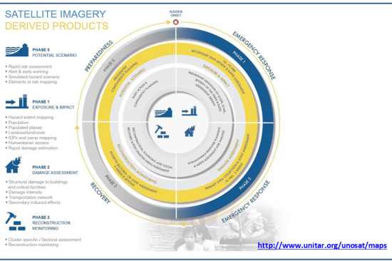
UNOSAT provides timely and relevant satellite imagery analysis to support different stages of the disaster risk management cycle: • Preparedness/Pre-Disaster phase: Multi-Hazard Risk Assessment, Alert & Early Warning, Elements at Risk Mapping, etc. • Emergency response 24 - 72 hours: Exposure and Impact Analysis (Hazard Extent Mapping, Population & Landuse/Landcover exposure, IDPs & Camp Mapping, Humanitarian Access, Rapid Damage Estimation) • Emergency response 72 hours - 2 weeks: Damage Assessment (Structural damage to buildings, transportation network, critical facilities). • Recovery phase: Imagery Analysis Support for Reconstruction Monitoring (Cluster Specific / Sectorial Assessments).
Since 2001, UNOSAT has supported, with satellite imagery analysis, UN Agencies and Member States for the majority of disaster events worldwide that required International Humanitarian Assistance.
Timely satellite imagery analysis is provided to humanitarian and development actors to support operational planning and decision making with reliable and evidence-based information.
• Report of the Executive Director of the United Institute for Training and Research to the General Assembly (Official Records, Fifty-ninth Session N. 14 (A/59/14) • Geo-information for Disaster Management, Peter van Oosterom, Siyka Zlatanova, Elfriede Fendel – 2006 (ISBN 978-3-540-27468-1) • Managing Crises and Disasters with Emerging Technologies: Murray E Jennex, Feb. P. (2016) FAO’s AVHRR-based Agricultural Stress Index System (ASIS) for global drought monitoring, International Journal of Remote Sensing, 37:2, 418-439, DOI:10.1080/01431161.2015.1126378