Rapid response mapping in support of rescue and relief effort
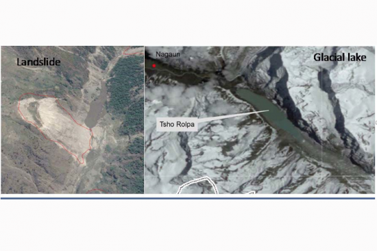
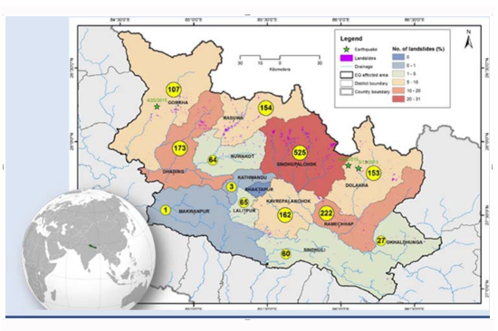
Close to 2000 landslides were mapped using a high-resolution image of the post 2015 Nepal Earthquake made available through International Charter for Space and Major Disaster, and Sentinel Asia. The images were geo-referenced if not done prior to visual scanning for a fresh scar from landslide and rockslide. Cross-checking with pre-event images most of which are available on Google Earth helped confirm whether or not the event is related to the earthquake. There are many large glacial lakes in and around the earthquake affected region, which was regularly monitored using multi-temporal high-resolution satellite data to pick up signs of potential failure. Mapping of landslide and monitoring of glacial lake using earth-observation data provided much needed situational awareness on the geo-hazard situation.
Application of earth-observation and remote sensing tools to map geohazard during major disaster event like an earthquake. Primary hazard like earthquake triggers secondary hazards such as landslide, rockslide and glacial lake outburst flood (GLOF). Landslide and rock- slide, in turn, can trigger tertiary hazard in the form of landslide dam outburst flood (LDOF). These events can take catastrophic dimension and needs regular monitoring to take timely action to minimize risk.
Post-event high-resolution satellite image is the first georeferenced and visually scanned for any fresh scar from recent landslide or rockslide. In case of citing of landslide or rockslide close to the river, construction of river with impounded water body is to be carefully checked. Regular monitoring of glacial lakes using temporal series of high-resolution satellite data to observe any change in lake dimension and moraine condition provides information necessary to access GLOF hazard.
Close to 2000 landslide mapped in 14 districts affected by 2015 earthquake, several landslides dammed a river and glacial lakes monitored in the aftermath of the earthquake
The approach provides a simple methodology to map and identify geohazard which has multiple utilities from effective response planning to long-term reconstruction.