It is very difficult for a single country to develop a basin-wide tsunami warning system. Therefore, the United Nations plays a major role in coordinating regional tsunami warning systems, and in ensuring that national capacities are strengthened to prepare for and cope with tsunamis.
Since 1965, the UNESCO Intergovernmental Oceanographic Commission (IOC) has been responsible for the coordination of the Pacific tsunami warning system. The Indian Ocean tsunami in 2004 gave renewed impetus to establish early warning systems worldwide, and the IOC was given the mandate to pursue this objective. On 12 October 2011, the tsunami early warning system for the Indian Ocean was launched, after approximately six years of development work. Similar warning systems are currently being developed in the Caribbean, the North East Atlantic, the Mediterranean and connected seas.
These regional tsunami warning systems are complete end-to-end warning systems, involving advanced technology for data sharing as well as comprehensive learning activities to teach coastal populations about tsunami danger and appropriate response. UNESCO-IOC helps professionals and populations to better anticipate the risks, to assess possible flooding and to coordinate monitoring. Several components of these end-to-end systems involve the use of satellite technologies, for example for hazard assessment and for warning dissemination.
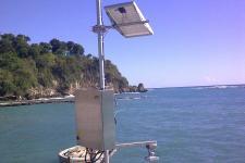
It is perhaps not that widely known that there are many sea level measuring stations around the world that transmit their observations every few minutes through several public geostationary satellites. From the ground receiving stations, this data is flowing via the Global Telecommunication System of the World Meteorological Organization into the information systems and large screens of dozens of sea level institutions, national tsunami warning centres, regional tsunami service providers, and international tsunami alerting centres in all basins.
With its Sea Level Station Monitoring Facility, the IOC provides an additional service to make this data available. Through this Facility, hosted by the Flanders Marine Institute (Belgium), the public and operators can access all the information they need with one click in order to monitor sea level variations in real time - be it for tsunami, storm surges, operational ocean forecasting or other purposes.
Read more here.

