![]()
United
Nations
Inundación
, processed by ESA, CC BY-SA 3.0 IGO.")
Definition
Facts and figures
Further information
UN-SPIDER Regional Support Offices with hazard-specific expertise
Related content on the Knowledge Portal

A knowledge platform for adaptation action on climate change recently updated the information, layout and logo of their website. With this step, adaptationcommunity.net aims to improve the user experience of the online platform and consequently facilitate the access to a wide variety of resources on climate change adaptation action, including tools working with Earth observation data.
Adaptation action in the context of climate change refers to “adjustments in ecological, social, or economic systems in response to actual or expected climatic stimuli and their effects or impacts. It refers to changes in processes, practices, and structures to moderate potential damages or to benefit from...
read more12/02/2021 of the European Commission.")
A new report outlines the impact of Global Human Settlement Layer (GHSL) data on various policy areas. The 2020 edition of the “Atlas of the Human Planet”, recently published and launched virtually by the Joint Research Centre (JRC) of the European Commission as a deliverable to the Group on Earth Observations (GEO) Human Planet Initiative, explores the impact of GHSL data on various policy areas, including disaster risk management.
GHSL data refers to “global spatial information, evidence-based analytics and knowledge describing the human presence on the planet”. This data relies on spatial information from Landsat 8, Sentinel-1 and Sentinel-2. It is mainly cost-free and...
read more18/02/2021.")
Recent advances in satellite technology in terms of higher spatial resolution, multi-spectral bands and open data access, have enhanced the ability for the monitoring and management of coastal areas. Satellite images are to be one of the most potential alternatives to water depth estimation due to the wide area coverage, repeatability, and low cost.
Depth retrieval can be achieved using either Analytical or Empirical Bathymetry methods. Empirical methods need additionally in situ measurements and can follow two approaches: Either the one of Lyzenga et al. (1978, 2006), proposing log-linear correlation between multiband and water depth values, and focusing mainly on removing all other reflected parameters attenuating water bottom signals, or the approach of Stumpf et al. (2003), using a ratio of bands and the difference in attenuation of different bands in water.
The characteristics of the nearshore are dependent on their bathymetry. Variations in the sea floor can...
read more
The world leading insurance and reinsurance provider Swiss Re recently partnered with the commercial synthetic aperture radar (SAR) satellite operator ICEYE to improve flood modelling and support disaster response efforts around the world.
A flood is a broad term that refers to “the overflow of water from a stream channel into normally dry land in the floodplain (riverine flooding), higher-than–normal levels along the coast and in lakes or reservoirs (coastal flooding) as well as ponding of water at or near the point where the rain fell (flash floods)“. Floods can pose a severe risk to natural environments, communities and their assets, agricultural areas, infrastructure and they are one of the most frequent and destructive natural hazards in...
read more15/03/2021 Publishing institution:
 Publishing institution:
.")
The use of multi-risk information systems is crucial in confronting the increasing risks posed by natural hazards. In some cases, risk is increasing due to inadequate land-use norms or regulations that allow for the construction of infrastructure in areas exposed to such natural hazards. In other cases, vulnerability increases due to lack of awareness or extreme poverty. The need to address risks from the point of view of multiple hazards is necessary to contribute to sustainable development and has been incorporated as an essential element of the Sendai Framework for Disaster Risk Reduction 2015-2030. For this purpose, the RIESGOS 2.0 project was launched in March 2021. Under the coordination of the German Aerospace Center (DLR), the project builds on the accomplishments of its predecessor - RIESGOS - as a multi-risk information system that models and simulates natural hazards to support disaster...
read more17/03/2021
Officially launched in 2015 by the National Aeronautics and Space Administration (NASA), the SMAP mission is an orbiting satellite that measures the amount of wetness in the top layer of soil incrementally every 2-3 days. These Soil Moisture Active Passive (SMAP) measurements rely on radiation frequencies that point to different levels of moisture on the surface of earth’s soil and are useful for scientists because it allows them to construct maps indicating the level of soil moisture globally. Acknowledging the relevance and usability of this data for the field of disaster management, NASA recently integrated the SMAP data into its Disasters Mapping Portal.
The Disasters Mapping Portal has been developed by the Geographic Informations Systems (GIS) Team at NASA in an effort to make their satellite...
read more25/11/2020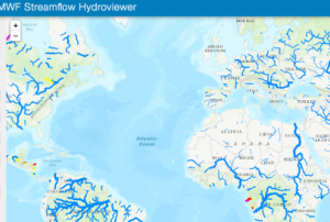 Publishing institution:
When disaster looms, early warning about potentially affected areas and the extent of the event are critical for disaster management efforts. Using in situ and satellite-based observations, two web-based systems provide critical information to support flood early warning efforts worldwide, for instance in the context of the current record-setting Atlantic hurricane season, which has brought widespread damage to countries in Central America. The GEOGloWS ECMWF Streamflow Hydroviewer and the Global Flood Awareness System (GloFAS) are easily accessible and free-to-use online tools that present information resulting from complex hydrological modelling in an accessible manner to support disaster management authorities and other stakeholders in preparing for floods. Both systems feature world map viewers that provide an overview of the local as well as the global hydro-meteorological situation. Outlooks from such systems are also increasingly used to take anticipatory humanitarian action...
read more20/11/2020
Term Parents
UN-SPIDER Regional Support Offices with hazard-specific expertise
![]()