Mass movements are massive failures of slope masses including rock, debris, soils and snow/ice (Parkash, National Institute of Disaster Management, New Delhi). These mass movements are sometimes associated with other disasters such as earthquakes, floods, thunderstorms, heavy rainstorm, etc. Mass movements also associated with manmade hazards like construction roads, buildings, structures, infrastructure facilities, etc. Mass movements are a variety of processes by which materials move through the hillslope system because of instability in the hillslope system[1]. Mass movements occur based on several factors and causes differ depending on different regions. Mass movements are affected by the slope gradient, climate, rock type and structure, physical setting and geological and geomorphological outlines[2]. One of the common mass movements are landslides.
1. Landslide
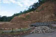
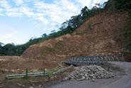
A landslide is the movement of rock, debris or earth down a slope. They result from the failure of the materials which make up the hill slope and are driven by the force of gravity. Landslides are known also as landslips, slumps or slope failure. Landslides can be triggered by natural causes or by human activity. They range from a single boulder in a rock fall or topple to tens of millions of cubic meters of material in a debris flow. They can also vary in their extent, with some occurring very locally and impacting a very small area or hillslope while others affect much larger regional areas. The distance travelled by landslide material also can differ significantly with slides travelling from a few centimetres to many kilometres depending on the volume of material, water content and gradient of the slope[3].
Source: PreventionWeb
See also detail information about landslides in Australia.
Characteristics[4]
The basic types of landslide movement are:
- Fall. This is generally characterized by rapid or extremely rapid rate of movement with the descent of material characterized by a freefall period. Falls are commonly triggered by earthquakes or erosion processes.
- Topple. This is characterized by the tilting of rock without collapse, or by the forward rotation of rocks about a pivot point. Topples have a rapid rate of movement and failure is generally influenced by the fracture pattern in rock. Material descends by abrupt falling, sliding, bouncing and rolling.
- Flow. This is the most destructive and turbulent form of landslides. Flows have a high water content which causes the slope material to lose cohesion, turning it into slurry. They are channelled by the landscape and move rapidly.
- Slide. This is one of the most common forms of failure and can be subdivided into translational and rotational slides. Rotational slides are sometimes called slumps because they move with rotation. Translational slides have a planar, or two dimensional surface of rupture. Slides are most common when the toe of the slope is undercut. They have a moderate rate of movement and the coherence of material is retained, moving largely intact or in broken pieces.
- Spread. This phenomenon is characterized by the gradual lateral displacement of large volumes of distributed material over very gentle or flat terrain. Failure is caused by liquefaction which is the process when saturated loose sediment with little or no cohesion such as sands or silts are transformed into a liquid-like state. This process is triggered by rapid ground motion most commonly during earthquakes.
Impacts/damages
Physical damage[5]:
- Anything on top of or in the path of a landslide will suffer damage.
- Rubble may block roads, lines of communication or waterways. Indirect effects may include loss of productivity of agricultural or forest lands.
- Flooding.
- Reduced property values, destruction of buildings.
- Casualties- fatalities may occur due to slope failure.
See also the impact of landslides on the environment in Kyrgyzstan and the effects of landslides on Machu Picchu cultural heritage and a Support Analysis Framework for mass movement damage in Calabria.
Emergency Action
What you should do if a landslide or debris flow occurs[6]:
- Stay alert and awake. Many debris-flow fatalities occur when people are sleeping. Be aware that intense, short bursts of rain may be particularly dangerous, especially after longer periods of heavy rainfall and damp weather.
- If you are in areas susceptible to landslides and debris flows, consider leaving if it is safe to do so. Remember that driving during an intense storm can be hazardous. If you remain at home, move to a second story if possible. Staying out of the path of a landslide or debris flow saves lives.
- Listen for any unusual sounds that might indicate moving debris, such as trees cracking or boulders knocking together. A trickle of flowing or falling mud or debris may precede larger landslides. Moving debris can flow quickly and sometimes without warning.
- If you are near a stream or channel, be alert for any sudden increase or decrease in water flow and for a change from clear to muddy water. Such changes may indicate landslide activity upstream, so be prepared to move quickly. Don't delay! Save yourself, not your belongings.
- Be especially alert when driving. Embankments along roadsides are particularly susceptible to landslides. Watch the road for collapsed pavement, mud, fallen rocks, and other indications of possible debris flows.
See also an emergency action guideline in redcross.org.
Mitigation
Mitigation measures[7]:
- Capture and drainage of water before it reaches potential slope area
- Underground drainage by using sub-surface pipes
- Land Reform by terracing/re-shaping
- Reforestation, planting of deep rooting trees to prevent surface slips
- Ground cover with grass or agricultural crops
- Use of Gabion construction to protect water course valleys and control the flow of water downslope
See also an example of landslide mitigation using geospatial technology in Nilgris and mitigation using zonation mapping in Sri Lanka.
2. Land Subsidence
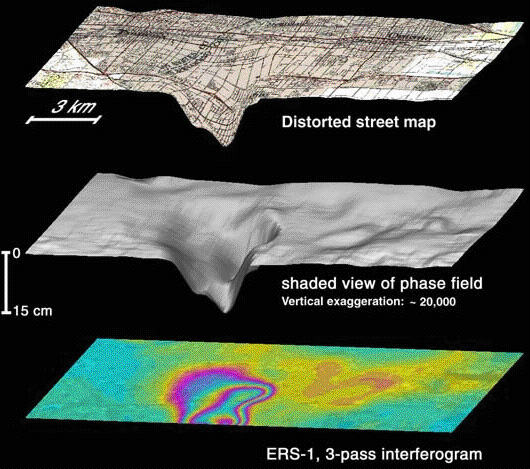 Land subsidence occurs when an amount of groundwater withdraws from certain types of rocks. The rocks compact because the water is responsible for holding the ground up. When the water is withdrawn, the rocks fall in on it. Common causes of land subsidence are from human activity such as pumping water, oil, and gas from underground reservoirs; dissolution of limestone aquifers (sinkholes); collapse of underground mines; drainage of organic soils; and initial wetting of dry soils (hydrocompaction)[8].
Source: USGS
Characteristics
An example of landslides characteristic can be read here. It is an example of land subsidence characteristics of Bandung (Indonesia) Basin between 2000 and 2005.
Impacts/damages
Land subsidence causes many problems including[9]:
- changes in elevation and slope of streams, canals, and drains;
- damage to bridges, roads, railroads, storm drains, sanitary sewers, canals, and levees;
- damage to private and public buildings; and
- in some coastal areas, subsidence has resulted in tides moving into low-lying areas that were previously above high-tide levels.
- failure of well casings from forces generated by compaction of fine-grained materials in aquifer systems.
See also the assessment of environmental impacts of subsidence by using radar.
Mitigation
Some mitigation plans that can reduce land subsidence hazard include:
- Identify and map areas with soil and geologic hazards and soil contamination.
- Require development proposals to assess soils and geologic hazards such as shrinks well potential, soil contamination, erosion, landslide and earth fissures from land subsidence.
- Require prevention measures when locating public facilities in areas subject to soils or geologic hazards, in order to avoid extraordinary maintenance or replacement cost.
For more a specific land subsidence mitigation plan which becomes a state policy action can be accessed here.
Further information
Several actions related to mass movements disaster management.
- Reducing the community impact of landslides in Australia, published by Emergency Management Australia (EMA).
- A scenario on landslide disaster management based on GIS Approach. (click here)
- Using GIS and remote sensing in Mass Movements hazard zonation in Iran.