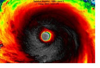
As ESA announced, the Meteosat Second Generation-4 (MSG-4) captured its first image of Earth yesterday, 4 August. At the same time, international satellites were providing critical information about the Super typhoon Soudelor’s, which is affecting the Pacific Ocean. These two events highlight the constant role Earth observation is playing in monitoring and forecasting climate events.
The first image captured by the Spinning Enhanced Visible and Infrared Imager (SEVIRI) instrument on MSG-4 has confirmed that Europe’s latest geostationary weather satellite is performing as expected as it becomes fully operational.
While MSG-4 was sending its first image, Japan’s Himawari-8 weather satellite, NASA’s National Polar-orbiting Operational Environmental Satellite System (NPOESS) Preparatory Project (NPP) satellite, NASA’s Aqua satellite and ISS-RapidScat instrument were following the super typhoon over the Pacific Ocean.
Himawari-8 provided one of the first insights into the storm; NPP’s VIIRS instrument provided an impressive I-Band image of the storm along with visible-light imagery; the MODIS instrument on Aqua satellite captured a visible-light image of Soudelor that clearly showed its 12-nautical-mile-wide eye; and RapidScat gathered surface wind speed and direction data on Soudelor.

