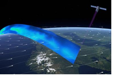
The European Space Agency is launching a new satellite that will help scientists better understand extreme weather patterns and also contribute to disaster preparedness through more accurate forecasting of meteorological disasters.
The Aeolus satellite will collect data using powerful lasers, which pulse ultraviolet light into the atmosphere. Data from the satellite, combined with a new supercomputer simulation that has been developed by the Met Office UK, should help scientists identify how climate change affects meteorological natural disasters and also assist meteorologists to forecast extreme weather forecasts.
The European Space Agency is set to launch the Aeolus satellite in August 2018 and once launched it will become the first satellite to directly observe wind speeds from space. Its main aim is to further experts’ knowledge of Earth’s atmosphere and weather systems, as well as to provide global observations of wind profiles. The Aeolus project expects to improve the quality of weather forecasts and to advance scientist’s understanding of atmospheric dynamics and climate processes.
Scientists have already installed a 1.5m telescope and ultraviolet lasers on board the satellite. This equipment detects wind speeds from tiny shifts in the light’s frequency by bouncing lasers through the Earth’s atmosphere. Applying this data to the Numerical Weather Prediction should make extreme weather forecasts more accurate.
The Aeolus mission will also contribute important data to improve scientists knowledge of all sorts of weather phenomena, from global warming to the effects of air pollution. The satellite will be a huge asset to weather forecasting models and disaster preparedness as the satellite provides currently unavailable data free for users
In a similar way, the Met Office UK’s new supercomputer is also contributing to extreme weather forecasts. Since 2003, scientists have worked on a coded computer model that maps out the Earth's atmosphere in extensive detail.
The supercomputer uses data gathered from the past 50 years to simulate extreme weather events, producing a range of outcomes. The computer then takes account of rising global temperatures and re-runs the simulations according to different degrees of global warming. The outcomes are used to calculate the effect of global warming on extreme weather trends, which can also be used in the prediction of disastrous meteorological events.
Data from the Aeolus satellite will be key to aiding these forecasts as it supplies regular specific data on previously unobserved air currents high above the tropics, which drives a large majority of European weather. Once launched, Aeolus will fly in a low Sun-synchronous orbit of 320 km above the Earth’s surface, meaning it will always be in the dusk or dawn position. Wind measurements will be taken at 90 degrees to the satellite ground track on the night side of the Earth.
The mission will provide global observations of wind profiles from space to improve the quality of weather forecasts and advance our understanding of atmospheric dynamics and climate processes.
The Aeolus satellite is now being checked and mounted with solar arrays at the Intespace space centre in Toulouse, France before it makes it way to French Guyana to launch upon the European Vega rocket on 21 August.

