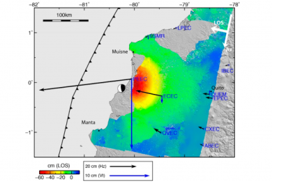
Spanish and Ecuadorian researchers have developed a new methodology to estimate faults and volcanoes that can be activated in a region after an earthquake. The approach consist in evaluating changes of static stress on the surrounding faults and volcanoes and producing maps of potentially activated faults and volcanoes.
The main goal of the study is to achieve an effective transfer of knowledge and scientific techniques to non-expert users who are responsible for the management of disasters and risks.
The study was led by researchers from the European Telecommunications Standards Institute (ETSI) in Topography, Geodesy and Cartography of the Polytechnic University of Madrid (UPM), along with the Complutense (UCM) and the Geological and Mining Institute of Spain (IGME).
These institutions are trying to improve the management of earthquakes and volcanoes through scientific methods using Interferometric Synthetic Aperture Radar (InSAR), NASA Shuttle Radar Topographic Mission (SRTM) Digital Elevation Model and 28 cGNSS stations from the Continuous Monitoring Global Navigation Satellite System (GNSS) Network (REGME), among others.
The results are presented in maps with a color scale type semaphore so that they are easy to understand, since one of the fundamental objectives of the research carried out is to use the scientific results obtained after an earthquake in post-event management.
The methodology has been applied to the earthquake that occurred off the coast of Ecuador in 2016 with a magnitude of Mw 7.8. It is based on the estimation of the changes of efforts in the faults and neighboring volcanoes that occur as a consequence of the release of energy due to the earthquake.
Considering the open data policy of Sentinel-1 SAR data, the availability of tools for the estimation of the earthquake source, and the evaluation of static stress changes, this methodology can be applied to earthquakes worldwide to quickly generate these maps after the earthquake and update them when additional data.

