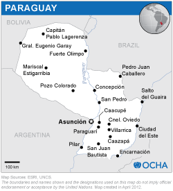
The mission was carried out with the support of experts from INPE and the Federal University of Santa Maria from Brazil, CONAE from Argentina, and IGAC from Colombia. The experts provided suggestions to AEP, SEN, and other government agencies on how to take advantage of the opportunities made available by the space community. For example, the expert from INPE raised awareness regarding the high-resolution satellite imagery available for Paraguay from the joint Chinese/Brazilian satellite CBERS 4a. Together with staff of the GeoLAB of AEP, the expert generated a 2-meter resolution map of Asuncion City and a 55-meter resolution map of the Republic of Paraguay. The Brazilian software TerraView, developed by experts at INPE, was used to generate these products.
The mission took note that several government agencies are using space-based information in their tasks, and the interest on behalf of other government agencies to continue using space-based information and technologies. Most institutions recognized the need for capacity building efforts to enhance their capacities to make use of such technologies.


