Tropical cyclones are one of the most powerful and destructive natural hazards. The interaction of various hazards during tropical cyclones, such as extreme winds, tornadoes, lighting, flooding, or storm surge, substantially increases the potential for life and property damage. According to the World Meteorological Organization, 1,942 disasters have been attributed to tropical cyclones over the past fifty years, causing more than 779,000 deaths and US$1,407 billion in economic losses.
Accurate forecasts can help governments and people to take early action to reduce the impacts of tropical cyclones in lives and properties. Satellites are an efficient way of gathering the necessary observations of cyclones so as to produce accurate forecasts, as they have a vast spatial coverage at higher global spatial resolution.
The National Oceanic and Atmospheric Administration (NOAA)'s National Centers for Environmental Information (NCEI) Blended Sea Winds (NBS) dataset synthesizes observations from multiple satellites to create gridded wind speeds. Gridded winds are spatial-temporal wind field grids that are averages of data onto a regular grid and makes sure that the data is available for every point on the global ocean. Without gridded winds, the data will be in the original pixel level of the satellite which has gaps. Blending data fills in the temporal and spatial data gaps present in the satellite datasets, and reduces subsampling aliases and random errors.
NBS blends several satellite estimates of surface wind, providing more accurate and gap-free observational data for model calibration and quality control. NOAA has been producing a global gridded 0.25-degree and 6-hourly sea surface winds product that has wide applications in marine transportation, marine ecosystem and fisheries, offshore winds, weather and ocean forecasts, among others.
The new version of NBS, NBS (v2.0) contains a long-term sea surface wind product from 1987 to the present that can easily delineate high storm winds starting in 2012 and with a one-day latency. This product has wide applications in marine transportation, marine ecosystem and fisheries, offshore winds, weather and ocean forecasts, among others.
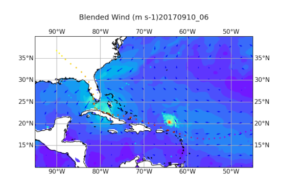
Main image: Image showing Hurricane Irma (near landfall in SW Florida), which was followed by Hurricane Jose, of the Gulf of Mexico in 2017. © NOAA