
Disaster Overview
The March 28, 2025, M7.7 earthquake near Mandalay, Burma (Myanmar), occurred as the result of strike-slip faulting between the India and Eurasia plates. Focal mechanism solutions indicate that slip occurred on either a north-striking, steeply-dipping, right-lateral fault or a west-striking, steeply-dipping, left-lateral fault. The finite fault solution indicates a north-striking right-lateral fault. This focal mechanism and finite fault solution are consistent with the earthquake potentially occurring on the right-lateral Sagaing Fault that lies in the fault zone that defines the plate boundary between the Indian and Sunda plates.
Reference: https://earthquake.usgs.gov/earthquakes/eventpage/us7000pn9s/executive
Objectives of this Web Report
This web report aims to analyze in detail the response of UN-SPIDER to the March 2025 Myanmar earthquake based on available information. It also aims to identify key private sector and academic partners who collaborated with UN-SPIDER in this response. Furthermore, it will investigate the specific types of satellites and the nature of satellite imagery used, the availability and content of publicly available maps showing the impact and damage of the earthquake, the cooperative relationship (if any) between UNOOSA/UN-SPIDER and Wuhan University and their respective contributions, how satellite imagery and damage analysis were used by relief organizations and government agencies in Myanmar, official acknowledgments of the contributions of private partners involved in providing satellite imagery, and the role of Regional Support Office.
Implementation of Satellite Image Acquisition and Analysis
UN-SPIDER's Role in Facilitating Access to Satellite Imagery
UN-SPIDER's primary function is to serve as a gateway to space-based information for disaster management support, connecting the disaster management community with the space community. This includes facilitating access to satellite imagery from various providers. UN-SPIDER has agreements with space-related stakeholders to showcase or provide high-resolution imagery to member states affected by disasters.
Provide Satellite Imagery from Space Startups and Academia
UN-SPIDER actively builds partnerships with public/private sector or academia satellite imagery providers to ensure timely access to critical data during disasters. These pre-established agreements streamline the process of acquiring necessary imagery, in addition to other major international schemes, such as the International Disaster Charter, Sentinel Asia, or Copernicus EMS.
Key Stakeholders providing satellite imagery during this disaster:
- Axelspace
- Maxar Technologies
- Open Cosmos
- Synspective Inc.
- China National Space Administration
- National Disaster Reduction Center of China, Ministry of Emergency Management
- Collaborative Network of Disaster Data Response (CDDR)
- Aerospace Information Research Institute of the Chinese Academy of Sciences (AIR)
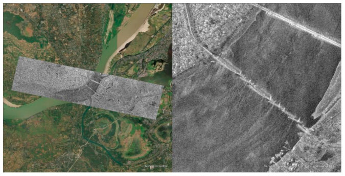
Detection of Ava Bridge Collapse by SAR imagery
SpotLight mode of SAR satellite imagery detected the collapse of the Ava bridge, a 16-span simply supported bridge between Ava and Sagaing, Mandalay Division, Burma.
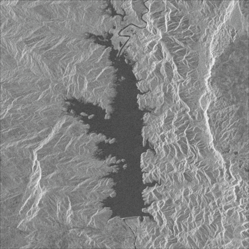
Daily Monitoring for Se Daw Gyi Dam by SAR satellite contellation
Synspective’s StriX series have taken daily SAR satellite imagery for Se Daw Gyi Dam, which are not safe for visiting after the Earthquake. Analysis of the SAR satellite imagery indicates that there are no significant landslides and no major damage to the earthen dam or erosion protection structures. The images have been taken from April 1st to 12th as the daily shots.
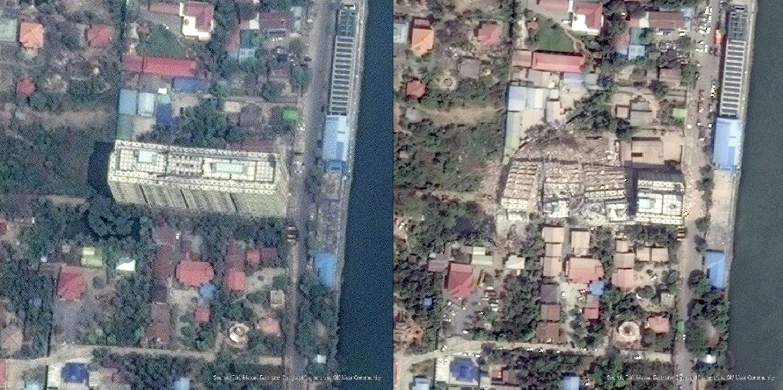
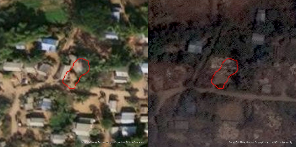
Collapse of Sky Villa Condominium building by Optical imagery
Maxar Technologies provided very high-resolution optical satellite imagery, WorldView Legion (Resolution: 30cm), to see any collapsed building or other infrastructure. Sky Villa Condominium building, which is a residential building with a G+10 story, collapsed due to the Earthquake.
Deliver Damage Assessment Result
Following the 2025 Myanmar earthquake, the National Disaster Reduction Center of China (NDRCC) in China and the Key Laboratory of Emergency Satellite Engineering and Application of the Ministry of Emergency Management, P.R.C. in China, collaborated with UN-SPIDER, and conducted a rapid damage assessment using satellite imagery and deep learning technologies.
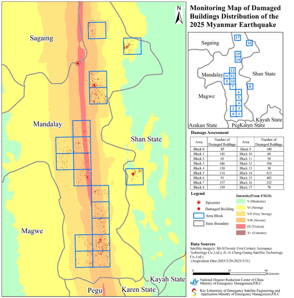
High-resolution data acquired from the BJ-3 (Beijing-3) and JL-1 (Jilin-1) satellite constellations between 29 and 31 March 2025 were used to map and evaluate damaged buildings across the affected areas in central Myanmar. The analysis applied deep learning-based change detection models to identify structural damages to buildings and houses within the earthquake's high-intensity zones.
The resulting Monitoring Map of Damaged Buildings Distribution presents a block-wise assessment, showing the number of damaged buildings in each area. The damage detection approach significantly improved the speed and accuracy of the emergency response assessment, supporting situational awareness and decision-making for both national authorities and international responders.
Potential of Satellite Constellations in Disaster Response and UN-SPIDER's Role
Earth Observation Satellites Contributing to the Disaster Response
When earthquakes and other natural disasters occur, Earth observation satellites can provide valuable information about the affected areas. These satellites carry various sensors, including optical and radar sensors, which can capture different aspects of the Earth's surface. Some of the satellites particularly useful in disaster response include:
- Very High-Resolution Optical Satellites capture detailed pre- and post-earthquake imagery, revealing damage to infrastructure and buildings. This imagery helps identify severely affected areas for resource allocation.
- SAR Satellites can observe the Earth's surface through clouds, making them useful for damage assessment even in adverse weather conditions.
- Commercial Satellite Constellations provide frequent coverage of the Earth, enabling rapid imagery acquisition during disasters. This imagery is crucial for initial damage assessments.
Data from these diverse satellite constellations is essential for a comprehensive understanding of the scale and impact of disasters, helping response agencies make informed decisions and effectively plan relief operations.
UN-SPIDER's Role in Disaster Response
UN-SPIDER plays a crucial role in facilitating access to space-based information for disaster management. This includes working with various satellite data providers, leveraging mechanisms like the International Charter, and providing technical assistance to countries affected by disasters. UN-SPIDER acts as a bridge between the space community and the disaster management community, striving to ensure that advancements in space technology contribute to disaster risk reduction and effective emergency response.
Global Satellite-Based Disaster Response Platforms
Several international platforms use satellite technology to support disaster response and emergency management for the Myanmar Earthquake:
International Charter "Space and Major Disasters"
The Charter is a global initiative that provides free and timely satellite imagery to support disaster response efforts. It is activated by authorized users during major disasters such as earthquakes, floods, and hurricanes. The Charter is a collaboration among space agencies, including ESA, NASA, CNES, and others, and aims to help first responders by delivering critical geospatial information.
https://disasterscharter.org/activations/earthquake-in-myanmar-activation-956-
Sentinel Asia
Led by the Asia-Pacific Regional Space Agency Forum (APRSAF) and supported by JAXA (Japan), Sentinel Asia provides space-based disaster monitoring services specifically for the Asia-Pacific region. It focuses on sharing satellite imagery and analysis with disaster management agencies in member countries, particularly for events such as floods, landslides, and forest fires.
https://sentinel-asia.org/EO/2025/article20250328MM.html
Copernicus Emergency Management Service (EMS)
Operated by the European Union, Copernicus EMS provides on-demand satellite mapping services to support emergency response in Europe and beyond. It offers two main components: Rapid Mapping, for fast disaster mapping within hours, and Risk & Recovery Mapping, for long-term planning and recovery support. It uses data from the Sentinel satellites and other contributing missions.
https://rapidmapping.emergency.copernicus.eu/EMSR798/reporting