
Background and Issues
Traditional Earth observation missions transmit large volumes of raw satellite data to ground stations before any meaningful analysis can occur. In disaster situations, this process causes delays that can reduce the effectiveness of early warning systems and slow emergency response. To overcome these limitations, satellites are now equipped with AI-enabled edge computing systems that can analyze data directly in orbit and transmit only the most relevant results.
In fast-moving disaster scenarios such as wildfires, floods, or landslides, timely, actionable intelligence is essential. Yet, downloading entire data swaths is both bandwidth-intensive and slow, and much of the imagery may be unusable due to factors like cloud cover or low-priority regions. By processing data onboard, satellites can automatically detect critical events, prioritize high-value imagery, and send key insights to decision-makers within minutes, enabling faster, more effective disaster response.
Technology
AI Onboard Processing
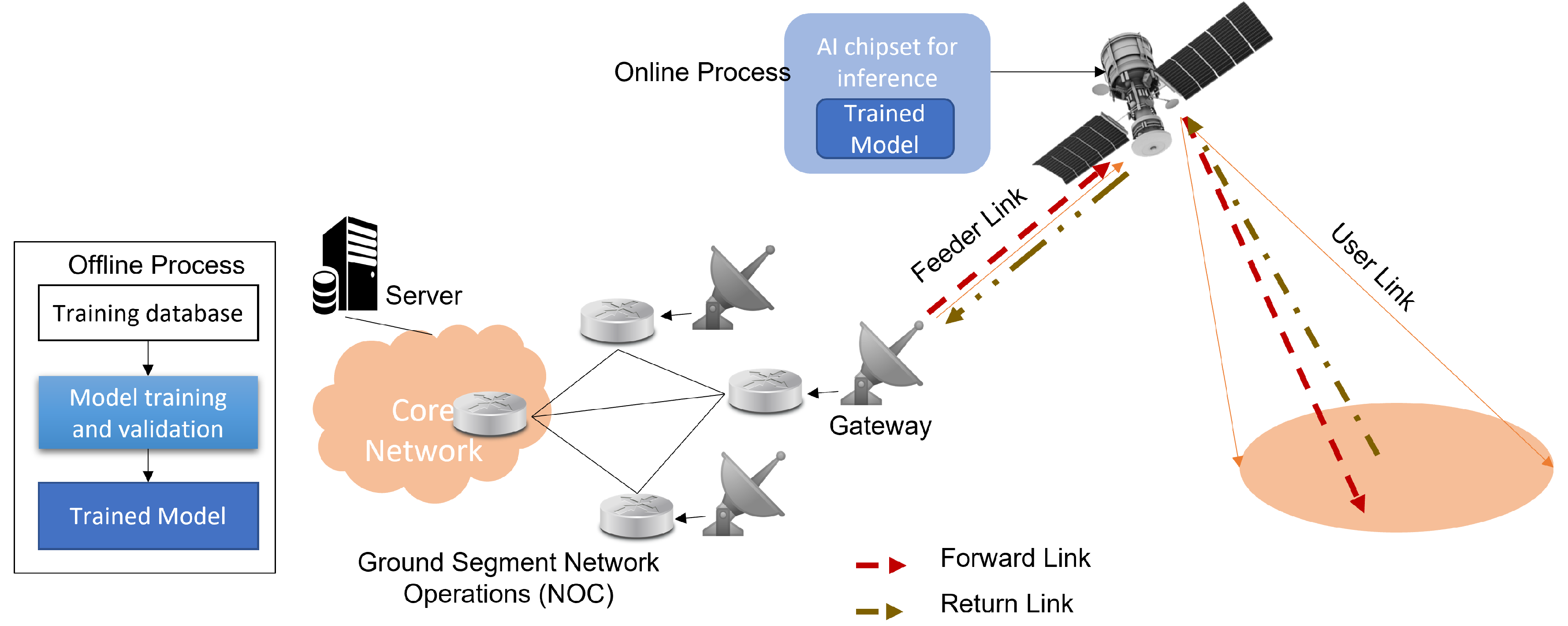
AI onboarding is the capability of a satellite to execute artificial intelligence and machine learning algorithms directly in orbit, eliminating the need to send vast amounts of raw data to Earth for later analysis. The satellite autonomously filters, analyzes, and interprets incoming data in real time, using models such as convolutional neural networks (CNNs) for image classification and object detection, semantic segmentation models for mapping land cover, flood extents, or burn scars, and multimodal fusion networks that combine radar (SAR) and optical imagery for all-weather monitoring (Ortiz et al., 2023). By processing data in space, this approach reduces latency, optimizes bandwidth, and ensures that only information meeting mission-defined thresholds is transmitted to ground stations.

Note. Reprinted from “Onboard processing in satellite communications using AI accelerators” by F. Ortiz, A. de la Fuente, L. García, P. Sánchez, & M. López, 2023, Aerospace, 10(2), 101
Edge Computing in Space
Edge computing refers to processing data as close to its source as possible, in this case, onboard the satellite itself, which acts as the “edge” of the network (Wu et al., 2024). This is enabled by high-performance, space-qualified processors such as hybrid CPU–GPU–FPGA architectures (e.g., NVIDIA Jetson modules, Xilinx space-grade FPGAs, Intel Movidius VPUs) capable of delivering up to 1,000 TOPS for AI workloads. AI models are optimized with frameworks to operate within strict power and memory limits. Smart data handling techniques, including autonomous filtering, compression, and prioritization, ensure only mission-relevant information is transmitted over limited downlink bandwidth. Additionally, radiation-hardened, fault-tolerant designs allow these systems to operate reliably in harsh spaces.
Operational Workflow
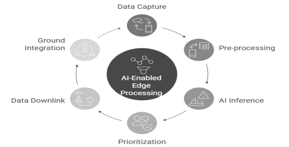
In a typical mission, sensors first capture imagery, whether multispectral, hyperspectral, or SAR, which is pre-processed onboard for radiometric correction, georeferencing, and cloud masking. AI algorithms then perform hazard detection, such as identifying flood zones, wildfire hotspots, or maritime vessels. A prioritization module assigns urgency scores, discarding irrelevant or low-quality imagery, before transmitting high-value results to the ground via radio frequency or high-speed optical links. This ensures that critical insights reach decision-makers in near real time.

Example Implementations:
STAR.VISION’s Onboard AI Processing Platform
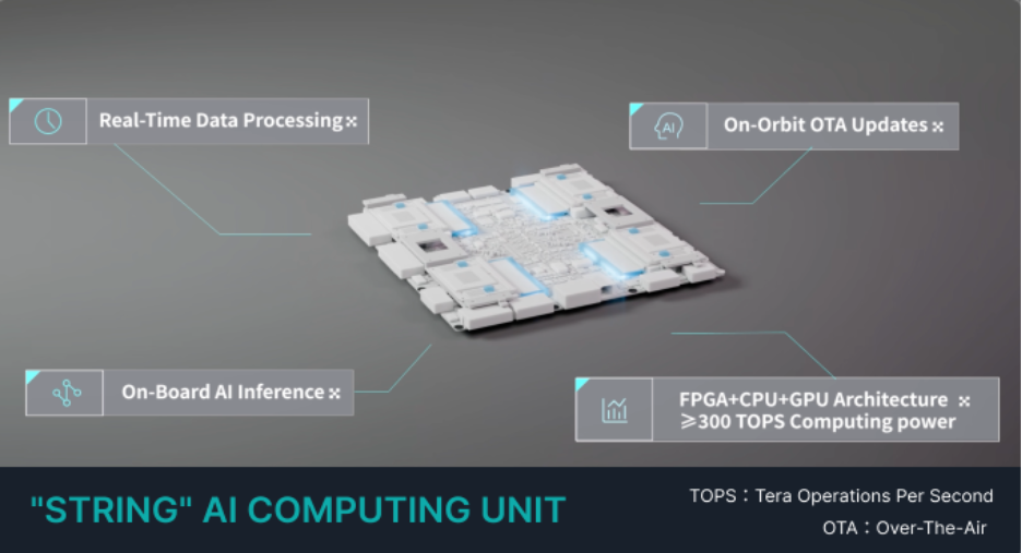
STAR.VISION has developed and space-qualified a robust onboard AI and edge computing platform that brings high-performance data processing directly into orbit. A flagship example of this technology is the String Edge AI Platform, an in-house designed payload processing unit with a hybrid FPGA+CPU+GPU architecture available in three configurations such as Light String (150 TOPS), String (300 TOPS), and Super String (1000 TOPS). This system can execute over 100 AI algorithms in real time, enabling intelligent image recognition, semantic segmentation, onboard compression, and the removal of invalid data before transmission (STAR.VISION Aerospace Group Limited, n.d.). By performing cloud detection, flood mapping, wildfire hotspot identification, SAR optical data fusion, and other disaster-relevant analyses directly onboard, the platform ensures that only high-value, actionable data is downlinked, reducing bandwidth usage by up to 80%. The inclusion of 100 Gbps laser inter-satellite links allows for distributed processing across multiple satellites, further accelerating response times.

Note. Adapted from STAR.VISION Aerospace Group Limited, “STRING AI Computing Unit” (n.d.), at https://star.vision/StringAiComputingUnit (accessed September 9, 2025). © STAR.VISION Aerospace Group Limited.
Beyond the String platform, STAR.VISION’s onboard AI and edge computing capabilities have been applied across a range of missions. In the Climate Change Impact on Caspian Sea project, satellites performed in-orbit analysis to track coastline changes and monitor water extent, enabling rapid assessment of environmental shifts linked to climate change. This work was presented at COP29 and demonstrated how real-time onboard processing can support global climate monitoring efforts.
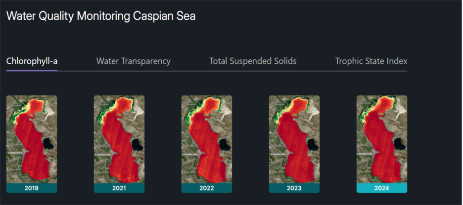
Note. Adapted from Water Quality Monitoring Caspian Sea (2019–2024) by STAR.VISION Aerospace Group Limited, 2024. Retrieved September 9, 2025, from https://star.vision/
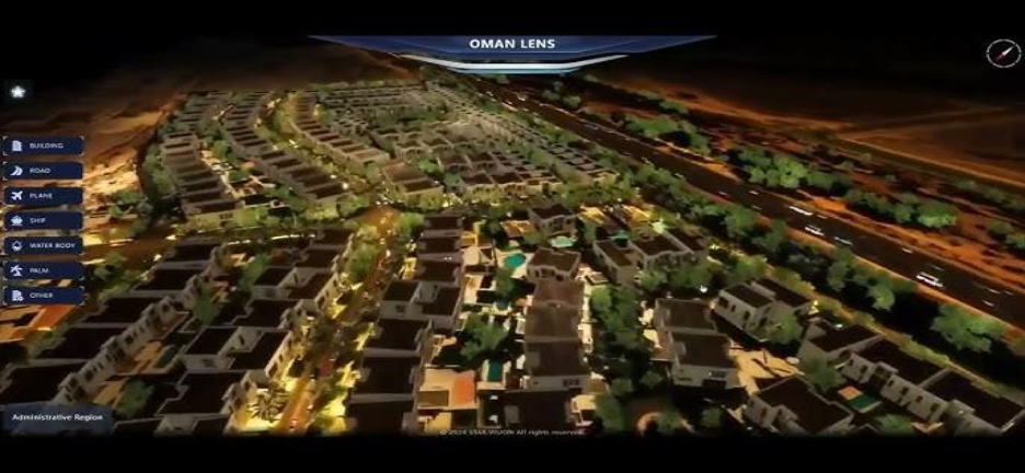
The Digital Twin City for Muscat, Oman initiative combined AI and stereo satellite imagery to produce 3D urban models, supporting building detection, green cover analysis, and road mapping for smarter urban planning and environmental management.

Note. Reprinted from “Muscat Digital Twin City Demo by STAR.VISION & Oman Lens” [Video], published by STAR.VISION & Oman Lens, accessed August 10, 2025, on YouTube. © STAR.VISION & Oman Lens.
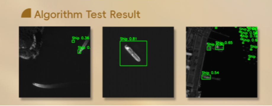
In the Kenya 2025 case, 58 students from 13 universities designed, tested, and deployed Earth observation AI algorithms in orbit, with outputs including ship detection, crop health monitoring, and land-use classification.

Note. Reprinted from “AI-powered Ship Detection for Maritime Surveillance” [Post], published by STAR.VISION Aerospace Group Limited on X July 16, 2025. Retrieved September 9, 2025, from https://x.com/starvision_cn
These examples illustrate the versatility of STAR.VISION’s AI-enabled satellite infrastructure, supporting applications from environmental monitoring and urban development to collaborative research and capacity building
Open Cosmos’ Modular AI Platform and Smart Constellations
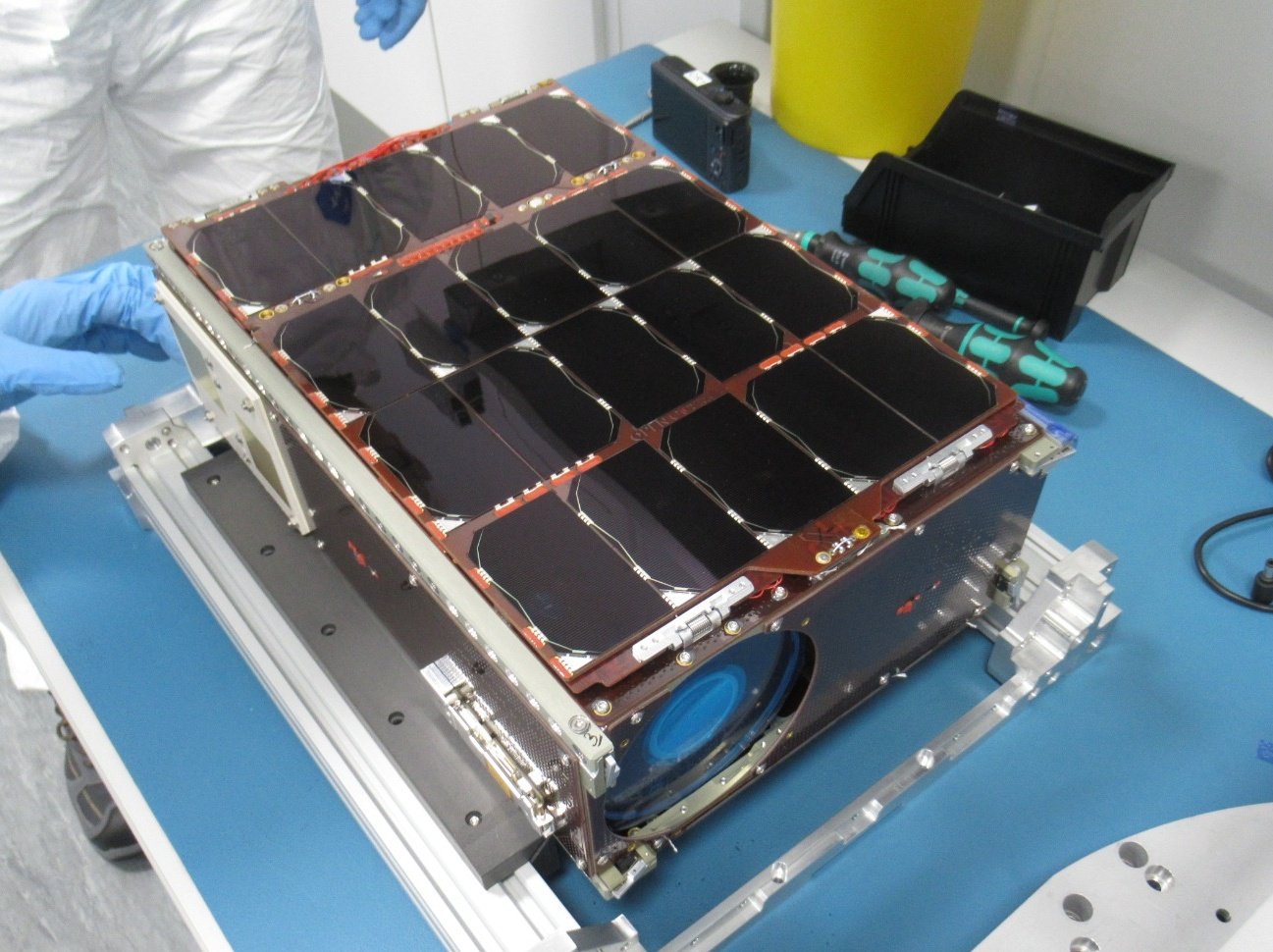
Open Cosmos has successfully integrated AI-driven edge computing into its satellite missions such as HAMMER and Φ-Sat-2, supporting a wide spectrum of Earth observation and disaster response applications. At the core of this capability is an onboard AI application framework deployed on their compact 6U CubeSats, which enables real-time execution of tasks like cloud detection, vessel identification, flooded-area mapping, and dynamic image compression (Open Cosmos Ltd., n.d.). These tasks are powered by the Intel Movidius Myriad 2 vision processor, which allows deep learning models to run directly in space.
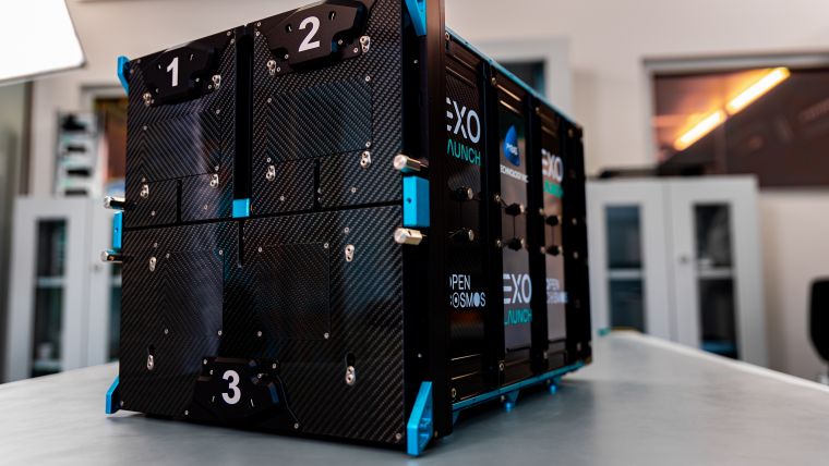
Note. Reprinted from AI-powered Phisat-2 launched by Open Cosmos and ESA, published by GIM International, August 20, 2024. Retrieved September 9, 2025, from https://www.gim-international.com/content/news/ai-powered-phisat-2-launched-by-open-cosmos-and-esa
A key innovation of the platform is its remote upgradability, allowing operators to install or update AI models post-launch, making the satellites adaptable to new missions or evolving disaster scenarios. Open Cosmos also drives collaboration through its shared satellite infrastructure, Open Constellation, a multi-partner network designed to democratize access to space data, and Data Cosmos, a cloud platform that delivers processed insights quickly and securely to users worldwide. Together, these technologies allow Open Cosmos to provide timely, intelligent, and scalable data services.
Note. Adapted from “Open Constellation” by Open Cosmos Ltd., n.d., Open Cosmos (https://www.open-cosmos.com/open-constellation). © Open Cosmos Ltd.
Conclusion
The integration of AI-enabled edge computing into satellite platforms has led to significant improvements in the timeliness and efficiency of disaster-related Earth observation. By processing data directly onboard, insights are now generated and delivered within minutes of image acquisition, compared to the hours or even days required by traditional ground-based pipelines. This capability enables faster situational awareness and more effective emergency response. Additionally, intelligent onboard filtering has reduced the volume of data transmitted to Earth by up to 80%, preserving bandwidth and lowering operational costs. These systems also promote increased autonomy, allowing satellites to operate with minimal ground control, particularly valuable in remote or disaster-affected areas with limited communication infrastructure. Importantly, the underlying architecture of these platforms is highly scalable and versatile, making them adaptable to a wide range of hazards, including wildfires, floods, marine pollution, infrastructure damage, and deforestation monitoring.
Future Directions
The next generation of AI-enabled edge computing in satellites is expected to advance in several key areas:
- Multi-Satellite Collaborative Intelligence: Future constellations will share and process data among satellites in orbit via high-speed inter-satellite links, allowing tasks such as distributed flood mapping or wildfire tracking to be performed collaboratively and in near real time.
- Adaptive AI Models: On-orbit machine learning models will evolve through continuous updates from the ground or even in-orbit training, enabling satellites to adapt to emerging hazards, changing landscapes, or new mission objectives without requiring hardware changes.
- Integration with Ground and Aerial Assets: Satellite edge processing will increasingly be linked with drones, aircraft, and IoT sensors, creating unified disaster monitoring systems that combine multiple vantage points and datasets for improved situational awareness.
- Energy-Efficient, Radiation-Hardened AI Chips: Hardware innovations will focus on reducing power consumption and increasing resilience to the harsh space environment, enabling higher performance without increasing satellite size or cost.
- Expanded Civil and Commercial Use Cases: Beyond disaster management, AI edge processing will support precision agriculture, maritime surveillance, infrastructure monitoring, climate change research, and urban planning, making the technology relevant across both public and private sectors.
Reference
Ortiz, F., de la Fuente, A., García, L., Sánchez, P., & López, M. (2023). Onboard processing in satellite communications using AI accelerators. Aerospace, 10(2), 101. https://doi.org/10.3390/aerospace10020101
STAR.VISION Aerospace Group Limited. (n.d.). STRING AI Computing Unit [Web page]. Retrieved September 9, 2025, from https://star.vision/StringAiComputingUnit
STAR.VISION Aerospace Group Limited. (2024). Water Quality Monitoring Caspian Sea (2019–2024) [Web page]. Retrieved September 9, 2025, from https://star.vision/
STAR.VISION & Oman Lens. (n.d.). Muscat Digital Twin City Demo by STAR.VISION & Oman Lens [Video]. YouTube. Retrieved September 9, 2025, from https://www.youtube.com/watch?v=XLoHl6a8lVo
STAR.VISION Aerospace Group Limited. (2025, July 16). AI-powered Ship Detection for Maritime Surveillance [Post]. X. Retrieved September 9, 2025, from https://x.com/starvision_cn
GIM International. (2024, August 20). AI-powered Phisat-2 launched by Open Cosmos and ESA. Retrieved September 9, 2025, from https://www.gim-international.com/content/news/ai-powered-phisat-2-launched-by-open-cosmos-and-esa
Open Cosmos Ltd. (n.d.). Open Constellation. Retrieved September 9, 2025, from https://www.open-cosmos.com/open-constellation
Wu, C., Li, Y., Xu, M., Guo, C., Yin, Z., Gao, W., & Chi, C. (2024). A comprehensive survey of orbital edge computing: Systems, applications, and algorithms. Chinese Journal of Aeronautics, 38(7). https://doi.org/10.1016/j.cja.2024.11.026