
UNU-EHS / ZFL / UN-SPIDER Course on GIS and Google Earth Engine
Bonn, Germany | 2 – 24 March 2026
From 2 to 24 March 2026, the United Nations University Institute for Environment and Human Security (UNU-EHS), the Center for Remote Sensing of Land Surfaces, University of Bonn (ZFL), and the UN-SPIDER Bonn Office jointly organised an intensive course on Geographic Information Systems (GIS) and Google Earth Engine (GEE). The course took place in hybrid format at the UNU-EHS premises in Bonn, Germany, over a period of approximately three weeks, totalling 23 hours of instruction and group work.
Course Structure and Content
The course brought together 13 participants, comprising students enrolled in the Joint Master's Programme in Geography of Environmental Risks and Human Security (offered by UNU-EHS and the University of Bonn) as well as UNU-EHS staff members. Many participants began the course with limited or no prior experience in GIS and remote sensing, making the depth of learning achieved all the more remarkable.
The training spanned ten thematic sessions and three tutorials, balancing conceptual foundations with intensive hands-on practice. The course opened with an introductory session delivered by Prof. Dr. Joerg Szarzynski of the UN-SPIDER Bonn Office, which set the broader context for the technical training that followed. Drawing on UN-SPIDER's mandate to ensure all countries can access and apply space-based information across the full disaster management cycle, the session introduced participants to the role of geospatial technologies, including GIS and Google Earth Engine, in supporting hazard assessment, early warning systems, rapid mapping, and post-disaster needs analysis. Students were introduced to how these tools are actively used in humanitarian response and international disaster aid coordination, bridging the gap between the space community and the operational realities of disaster management. Topics in subsequent sessions ranged from the fundamentals of GIS and cartography to applied remote sensing workflows, and included a dedicated session on the validation of geospatial results. The course concluded with group presentations on 24 March.
From Zero to Workflow: A Rapid Capacity-Building Journey
Perhaps the most striking outcome of the course was the speed at which participants progressed. Starting from limited or zero prior knowledge of GIS and remote sensing, they rapidly became familiar with core geospatial workflows in both QGIS and Google Earth Engine. By the end of the course, participants were capable of not only following the taught workflows, but adapting them to their own regions of interest and research questions.
Group Presentations: Applied Geospatial Analysis
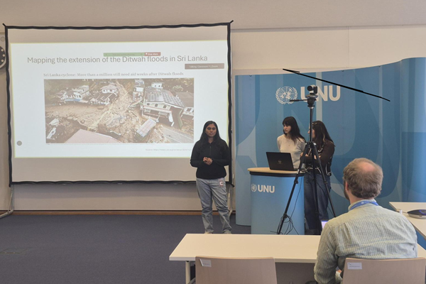
The course culminated in group presentations in which participants applied the drought and flood monitoring workflows introduced during the sessions to their own chosen regions. Each group produced:
- Zonal analysis of their selected region, encompassing indicators such as exposed population and affected areas
- Map visualisations presenting the spatial outputs of their analysis in a clear and communicable format
This exercise demonstrated that participants had not only acquired technical skills but had developed the confidence to tailor geospatial workflows to specific scientific and policy-relevant contexts.
Participant Feedback
Feedback from participants was broadly positive. Despite the relatively short duration of the course, participants reported having gained sufficient knowledge and practical experience to understand the core workflows and adapt them independently for their own scientific purposes. This reflects the effectiveness of the course design, which balanced conceptual grounding with intensive hands-on practice.
Instructors and Tutors
The course was delivered by a team of lecturers from the three organising institutions. David Daou (Associate Academic Officer, Climate Risk Analytics Team, UNU-EHS), Martin Hilljegerdes (Researcher, ZFL, University of Bonn), Mostapha Harb (Geospatial Data Scientist, former UNU-EHS colleague), Joerg Szarzynski (Officer in Charge, UN-SPIDER Bonn Office) and Thilanka Seneviratne (Associate Programme Officer) collectively covered the full breadth of the curriculum. Two tutors provided support throughout the course: Thanh-Loc Nguyen (Research Associate, Climate Risk Analytics Team, UNU-EHS) and Mehraveh Sakhaei (Intern, UN-SPIDER Bonn Office).
Key Takeaways
The course reinforced a broader message that is central to the work of UNU-EHS, ZFL, and UN-SPIDER: the integration of space-based technologies and geospatial workflows into multi-hazard risk studies is not optional, it is essential. Satellite-derived data and platforms such as Google Earth Engine offer scalable, cloud-based solutions for monitoring environmental hazards, assessing exposure, and supporting evidence-based decision-making in disaster risk management.
For participants wishing to explore further geospatial workflows beyond those covered in the course, the UN-SPIDER Knowledge Portal offers a wide range of freely accessible Recommended Practices for disaster risk reduction applications.