  • English
  • Español
  • Français

United
Nations


Office for Outer Space Affairs
UN-SPIDER Knowledge Portal

  • Accueil
  • À propos
    • Qu'est-ce que l'ONU-SPIDER?
    • À propos d’UNOOSA
    • Publications
    • Offres d'emploi
    • Rencontrez l'équipe
    • Contact
  • Applications spatiales
    • Technologie satellitaire
    • Mécanismes d’urgence
    • Recovery Mechanisms
    • Réseau international d'alerte aux astéroïdes
    • Space Mission Planning Advisory Group
    • Initiative internationale sur la météorologie spatiale
    • Les technologies spatiales à l'ONU
    • Comptes-rendus d'utilisateurs
  • Liens & ressources
    • Application de données du mois
      • Disaster Recovery
    • Sources de données
    • SIG et logiciels de télédétection
    • Online Learning Resources
    • Institutions
  • Risques & catastrophes
    • Prévention des risques de catastrophe
    • Systèmes d'alerte précoce
    • Gestion des catastrophes et des interventions d'urgence
    • Aléas naturels
    • Cadre d'action de Sendai
    • L'ONU et la prévention des risques de catastrophe
    • L'ONU et les alertes précoces
    • L'ONU et la gestion des catastrophes
  • Appui technique
    • Missions Conseil
    • Appui d’urgence
    • Appui à distance
    • Pratiques recommandées
    • Activités de formation
    • Utilisations pratiques
  • Réseaux
    • Bureaux régionaux d’appui
    • GP-STAR
    • MHEWS
    • IWG-SEM
  • Projets
    • SPEAR
    • SEWS-D
    • EvIDENz
    • Flood GUIDE
  • Actualités
    • Actualités
    • Événements
    • Événements passés

Breadcrumb

  • Home
  • Aqua
  • Aqua

Aqua

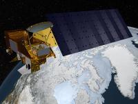
Aqua, Latin for water, is a NASA Earth Science satellite mission named for the large amount of information that the mission is collecting about the Earth's water cycle. The Aqua mission is a part of the NASA-centered international Earth Observin System (EOS). Aqua was formerly named EOS PM, signifying its afternoon equatorial crossing time.
Aqua was launched on May 4, 2002, and has six Earth-observing instruments on board, collecting a variety of global data sets. Aqua was originally developed for a six-year design life but has now far exceeded that original goal and is expected to be operating into successfully into the early 2020s. It continues transmitting high-quality data from four of its six instruments, AIRS, AMSU, CERES, and MODIS, and reduced quality data from a fifth instrument, AMSR-E. The sixth Aqua instrument, HSB, collected approximately nine months of high quality data but failed in February 2003.

Instruments:
Atmospheric Infrared Sounder (AIRS)
Advanced Microwave Sounding Unit (AMSU-A)
Humidity Sounder for Brazil (HSB)
Advanced Microwave Scanning Radiometer for EOS (AMSR-E)
Moderate-Resolution Imaging Spectroradiometer (MODIS)
Clouds and the Earth's Radiant Energy System (CERES)

4 May 2002
6years
Polar
Sun synchronous
99 minutes
Advanced Microwave Scanning Radiometer - Earth Observing System
Advanced Microwave Sounding Unit - A
Atmospheric Infrared Sounder (AIRS)
Moderate-Resolution Imaging Spectroradiometer
MODIS
NASA
Collecting information about the Earth’s water cycle including evaporation from the oceans, water vapor in the atmosphere, clouds, precipitation, soil moisture, sea ice, land ice, and snow cover on the land and ice. Additional variables being measured include radiative energy fluxes, aerosols, vegetation cover on the land, phytoplankton and dissolved organic matter in the oceans, and air, land, and water temperatures.
Efflorescences algales nuisibles
Sécheresse
Tsunami
Inondation
Tempête sévère
Température extrême
No
Information about Aqua on NASA web page

Footer menu

  • Contact
  • Terms of Use

User account menu

  • Log in