Sentinel Asia is an international cooperation platform that brings together space agencies, disaster management agencies and international agencies on a voluntary basis to combat natural disasters in the Asia-Pacific region by using remote sensing and Web-GIS technologies. Sentinel Asia was established in 2005 as an initiative under the Asia-Pacific Regional Agency Forum (APRSAF). The Japan Aerospace Exploration Agency (JAXA) serves as the executive secretariat of Sentinel Asia and the number of Sentinel Asia member organizations amounts to more than one hundred.
Since its establishment, Sentinel Asia has evolved step by step. In the course of the first pilot phase, “Step-1”, Sentinel Asia demonstrated relevant technologies and established its backbone data dissemination system. Sentinel Asia then established operational mechanism of emergency observation during the next step, “Step-2”. Based on the successful completion of previous steps, in 2013, APRSAF endorsed and recommended that Sentinel Asia proceed to Step-3 which aims at covering the entire disaster management cycle. The Steering Committee was established for strategic management of Sentinel Asia. In 2018, the ten-year Strategic Plan of Sentinel Asia, proposed by the Steering Committee, was established. Members of Sentinel Asia are expected to address the actions jointly by reviewing and revising, where necessary.
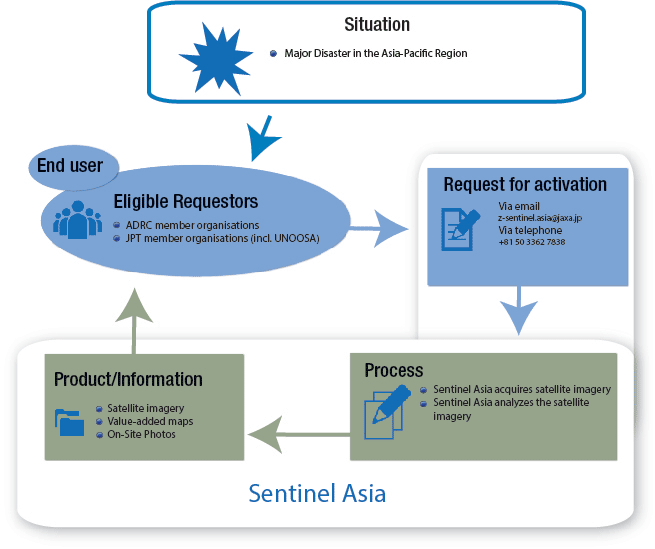
When natural disasters occur, users make emergency observation requests to the reception desk, the Asian Disaster Reduction Center (ADRC). After clarification concerning the needs of users (where necessary), the requests are sent to space agencies, called “Data Provider Nodes (DPNs). Then, DPNs contribute satellite images and the satellite images are turned into damage maps by data analysis support organizations called “Data Analysis Nodes (DANs)”. These maps are then provided to users through the Sentinel Asia website. Since its establishment, Sentinel Asia has conducted more than 300 emergency observations.

Eligible requestors/End-users
Eligible requestors for Sentinel Asia are Asian Disaster Reduction Centre (ADRC) member organizations and representative organizations of the JPT. Membership of the JPT is open to all APRSAF member countries, disaster prevention organizations, and regional/international organizations prepared to contribute their experience and technical capabilities. They are also encouraged to participate in disaster information sharing activities.
Conditions for Activation
Upon request, Sentinel Asia is able to provide geo-spatial information derived from earth observation satellites in case of major disasters; in addition to wildfire, flood and glacier lake outburst flood monitoring.
Request/Point of Contact
Eligible requestors can request the activation of the mechanism via email (z-sentinel.asia [at] jaxa.jp) or telephone (+81-50-3362-7838).
Process
Currently, Sentinel Asia uses data received from the following satellites: “ALOS-2” (JAXA), “Dubaisat-2” (MBRSC), “Formosat-5” (NSPO/NARLabs), “Resourcesat-2” (ISRO), “Taichote” (former “THEOS”) (GISTDA), “VNREDSat-1” (VAST/STI). Also, upon request from users, Sentinel Asia’s emergency observation requests can be promptly escalated to the International Disaster Charter by ADRC. This escalation mechanism is called “Sentinel Asia Escalation”. As the satellite sources of Sentinel Asia and the International Disaster Charter are different, this Sentinel Asia Escalation enables users to benefit most from both platforms.
Products
Sentinel Asia provides satellite imagery (to the extent permitted by the imagery provider) and value added maps highlighting the affected areas, as well as on-site digital photos of the disaster area. The initiative also shares data on wildfire hotspots and rainfall information derived from satellite data and meteorological satellite information. This information is then made available on the web, or via satellite communication.
