  • English
  • Español
  • Français

United
Nations


Office for Outer Space Affairs
UN-SPIDER Knowledge Portal

  • Accueil
  • À propos
    • Qu'est-ce que l'ONU-SPIDER?
    • À propos d’UNOOSA
    • Publications
    • Offres d'emploi
    • Rencontrez l'équipe
    • Contact
  • Applications spatiales
    • Technologie satellitaire
    • Mécanismes d’urgence
    • Recovery Mechanisms
    • Réseau international d'alerte aux astéroïdes
    • Space Mission Planning Advisory Group
    • Initiative internationale sur la météorologie spatiale
    • Les technologies spatiales à l'ONU
    • Comptes-rendus d'utilisateurs
  • Liens & ressources
    • Application de données du mois
      • Disaster Recovery
    • Sources de données
    • SIG et logiciels de télédétection
    • Online Learning Resources
    • Institutions
  • Risques & catastrophes
    • Prévention des risques de catastrophe
    • Systèmes d'alerte précoce
    • Gestion des catastrophes et des interventions d'urgence
    • Aléas naturels
    • Cadre d'action de Sendai
    • L'ONU et la prévention des risques de catastrophe
    • L'ONU et les alertes précoces
    • L'ONU et la gestion des catastrophes
  • Appui technique
    • Missions Conseil
    • Appui d’urgence
    • Appui à distance
    • Pratiques recommandées
    • Activités de formation
    • Utilisations pratiques
  • Réseaux
    • Bureaux régionaux d’appui
    • GP-STAR
    • MHEWS
    • IWG-SEM
  • Projets
    • SPEAR
    • SEWS-D
    • EvIDENz
    • Flood GUIDE
  • Actualités
    • Actualités
    • Événements
    • Événements passés
  • Admin
    • SAM Items

Breadcrumb

  • Home
  • Turning Satellite Images Into Disaster-Relief Efforts
  • Turning Satellite Images Into Disaster-Relief Efforts

Turning Satellite Images Into Disaster-Relief Efforts

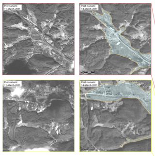
Several academic institutions are teaming up in an effort organized by the U.S. Geological Survey to help turn satellite imagery into actionable data in Japan. Satellite photos tell a powerful story, of course. But they also can be used as leverage in relief efforts. A team at Rochester Institute of Technology, together with several other institutions (Harvard, George Mason, and Penn State, among them), are turning satellite photos into actionable data that the Japanese can use in relief efforts.

On the simplest leve a satellite photo can tell you which road to take, and which to avoid. But the RIT team goes much deeper than that, mining imagery for data used in logistics. For example, a Japanese relief team might know that certain segment of a town lies in rubble. But they might not know the volume of the rubble--just how large a fleet of trucks they'll need to clear away the debris. Using something called Geographic Information Systems software (GIS), researchers can trace lines around a pile of rubble, and the software will instantly tell you the size of the pile.

Pre- and post-quake imagery makes automation possible. A program could compare and contrast the two images much as in the NYT slider feature and could automatically calculate the devastation that way. Other research might enable the automatic detection of rubble, since debris has a random structure, as opposed to the regular orderly grid of the road and buildings in most towns and cities.


FastCompany on March 28, 2011
Wed, 30 Mar 2011 - 10:59

Footer menu

  • Contact
  • Terms of Use

User account menu

  • Log in