Anton Donner and Javier Mulero Chaves
DLR, Institute of Communications and Navigation, Weßling/Oberpfaffenhofen, Germany
Introduction
The World Health Organization (WHO) gives the following definitions of disasters and emergencies:
“Disasters are events that occur when significant numbers of people are exposed to hazards to which they are vulnerable, with resulting injury and loss of life, often combined with damage to property and livelihoods.”
and
“Emergencies are situations that arise out of disasters, in which the affected community’s ability to cope has been overwhelmed, and where rapid and effective action is required to prevent further loss of life and livelih-ood.” (1)
These definitions imply that emergencies are characterized by limited resources in terms of medical personnel and infrastructure, which underlines the importance of mobilizing regional, supra-regional and/or international help to the affected regions. Effective deployment of this help is crucial but only possible if a common operational picture between authorities, coordination centers, and staff working in the field is rapidly developed.
Upon arrival on site, the first task of a rescue team is to look for injured persons and to assess the situation. For scenarios with many (seriously) injured persons, many countries have foreseen a standard procedure for the initial scouting, known as “triage”. According to it, teams consisting of medical doctors or paramedics classify victims according to different categories (e.g., immediate, delayed, minor, no chance of survival) and attach paper labels to the victims.
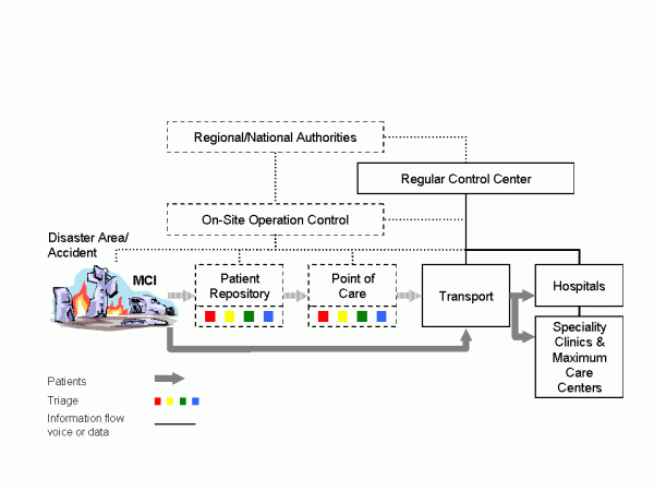
Paper-based triage and registration systems are still state-of-the-art, because they are robust and their usage is intuitive. Nevertheless, the main drawback is that information about affected persons remains among the persons themselves, making disaster management considerably more difficult. Data can be duplicated/ aggregated by manually copying triage tags only, which is a laborious and time-consuming process. Moreover, as soon as there is more than one rescue team (organization) involved maintaining different lists, or there is more than one access to the disaster area (which is the typical case for wide-area disaster events with large geographical extension, like earthquakes), registration of injured/affected persons turns out to be a logistic problem since it can only be performed at defined transfer points. Besides, experience has very often shown that injured persons ‘bypass’ the theoretical work flow of the rescue chain (see Figure 1), because passers-by or relatives take them to the nearest hospitals. This effect implies an additional problem, namely a saturation of the geographically nearest hospitals, which very often do not have a communication return channel to coordination centers.

Figure 1: Present work flows and operation control for individual rescue (solid lines and blocks) and MCI (dashed lines and blocks).
Indeed, triage and registration performed at different places by different teams maintaining different lists are indubitably an error-prone approach. It can happen that all later attempts to track the way of single patients, their attendants and transport vehicles are not very successful, although this could be of key interest in scenarios with nuclear, biological or chemical hazards. Last but not least, relatives have a legitimate interest in the whereabouts of their family members.
Communication and dissemination of this information in order to provide coordination centers with an accurate situation overview (i.e. number of victims, injury categories and their location) becomes one of the main challenges to overcome, since the normal medium nowadays for exchanging information are voice-based radio systems.
Key concept
Earlier works have already described concepts for and advantages of IT-supported MCI management, which can be applied not only to operations in the field, but also to emergency rooms of hospitals. A comprehensive overview can be found in (2). Some of these system architectures include wearable sensors with wireless connectivity, e.g. (3), (4); others use radio-frequency identifications (RFIDs) in read/write mode, e.g. (2), (5), which means that data is stored both in the RFID chip and transmitted from a handheld device to a database. The main objective of this article is to describe the e Triage approach (6), which is a research project funded by the German Federal Ministry of Education and Research and which consists of four main elements: autonomous communication infrastructure, electronic data recording, a distributed database system (7), and psychological acceptance research. Outcome of the project will be a demonstrator system for registration of affected persons of an MCI. In more details, the e-Triage system comprises a satellite-based communication system with terrestrial radio cells that can be installed in the field, matching end devices with dedicated application software for the registration of victims, and a distributed, self-synchronizing database system guaranteeing maximal availability without a single point of failure. Main differences to approaches described in literature are:
- Sensors monitoring vital parameters of single patients might be a valuable tool in hospital environments, but for e-Triage the concept decision was to apply a simple classification scheme only.
- Triage tags (registration cards or colored wristbands) are not used as data storage media. Instead, a triage tag is labeled with a unique identifier (ID) in different formats only (RFID, optical matrix code, human readable text). With the ID the patient’s data set can be obtained from the database.
- A distributed database system mapping IDs to persons is a key component of the approach. Not only hardware with optical/RFID scanners can be used to obtain the patient ID, but also notebook or desktop computers may be used for this purpose (with the database software running from external flash drives and the ID typed in with a normal keyboard).
- User terminals are designed primarily for regular rescue services, so that in case of a disaster they are instantly available.
Unique electronic labels remaining attached to victims show advantages for the subsequent rescue chain: due to the contact-free readability it is possible to equip ambulances and doorways of (field) hospitals with scanners which automatically transmit the new location (and/or the geographical position) of the respective person to the control center via various complementary wireless transmission links (see below). Additionally, patients could change their status (e.g., from category II “delayed” to category I “immediate”) and this information is fed into the continuously updated distributed database allowing an operation control to trace how the situation evolves. On site forces can be redeployed and additional forces dispatched on the fields. (Field-) Hospitals can organize their care capacity, call for back-up personnel and send feedback reports to remote coordination centers. Last but not least, information regarding the whereabouts of the victims is easily obtainable and the entire information base is available for a later evaluation since MCIs are always subject to later police investigation.
Data management

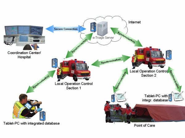
Figure 2: Distributed database system (DDBS) concept and synchronization of DDBS instances along the rescue chain.
Albeit the main challenge for the e-Triage system is aggregation of distributed data acquired from many terminals in the field, a fully centralized approach for data storage is not desirable. Rescue operations are temporally and spatially distributed events. Thus, a distributed data management approach has to be applied (see Figure 2). Arriving triage and medical rescue teams have to be able to start working immediately without having to wait for the communication infrastructure to be set up. Furthermore, all the collected data needs to be forwarded to local and remote decision makers automatically. As an integral part of this architecture, network outages or node failures have to be anticipated. Thus, the underlying storage technology will be a distributed database system (DDBS), which has to cope with a variety of different communication technologies, including terrestrial wireless and satellite links with different bandwidths. A basic assumption for the design is that, on the one hand, the network topology might change at any time. On the other hand, all involved communication links are not reliable so that intermittent network outages might occur (e.g., end devices leaving the coverage area of the locally installed radio cells). Nodes of this DDBS are installed in all mobile user terminals (tablet-PCs), at communication nodes (OSECEs), and in the remote area. The DDBS discovers joining and leaving nodes, and (re-)joining nodes have to be synchronized with the core DDBS. This design supports even scenarios with no network connectivity at all: it is possible to synchronize database nodes by exchanging flash memory cards.
Communication

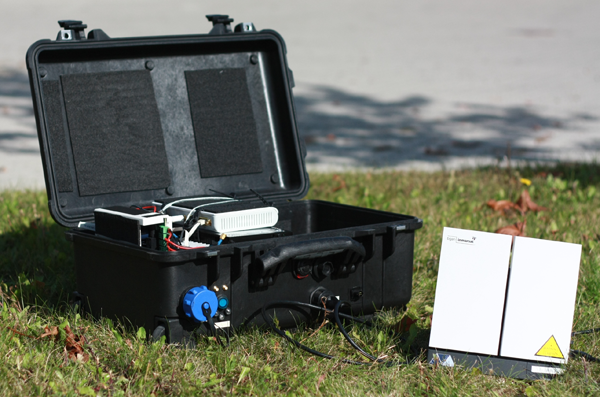
Figure 3: e-Triage communication suitcase (on-site emergency communications equipment, OSECE) consisting of an Inmarsat BGAN satellite terminal, a GSM pico cell, and a WLAN router (9).
An electronic registration system for MCIs requires wireless communication services, and since local infrastructures may not exist at all or can be destroyed, it is of paramount importance that at least a temporary communication system is set up. Even if functioning networks exist, it is most likely already saturated by the affected persons using their mobile phones. For rescue missions in less densely populated or less developed or seriously destroyed countries satellite phones (e.g., Globalstar or Iridium) are commonly used during the first hours/days. The idea of backhauling terrestrial cellular networks via a long-haul satellite link is not new and commercial products already exist. An example is Emergesat by Thales Alenia Space which has been designed to fit into a container for air freight. Disadvantage of this solution is that it is rather bulky and transport into an affected area can be rather challenging. The development of a more flexible and faster deployable solution has been initiated in the WISECOM project (8) and is currently continued within e-Triage. The basic design goal is that the complete on-site emergency communications equipment (OSECE) fits into a hand-luggage size suitcase. The chosen satellite technology is Inmarsat BGAN, which is globally available but offers limited bandwidth only, and the resulting suitcase prototype is 56cm x 35cm x 23cm, including a battery pack for a few hours runtime (9). The BGAN terminal itself needs only to be taken out of the suitcase, and the antenna can be easily pointed to the satellite within a few minutes.
A second more powerful OSECE system is currently under development for use in mobile coordination centers, which is based on a commercial Very Small Aperture Terminal (VSAT) satellite system and which offers more capacity and wider terrestrial coverage. Manual alignment of the antenna reflector (diameter ca. 1 m) is not an option for this application, so the decision was to use a self-aligning antenna unit which can be mounted on a suitable vehicle.
The quasi-stationary OSECE nodes include several base-stations for different wireless technologies:
- WLAN: Data communication as well as Voice over IP (VoIP) calls can be provided by WLAN access points. For the registration of affected persons WLAN is the preferred medium since it offers sufficient bandwidth for many terminals in parallel.
- GSM/GPRS: These well-known standards allow voice and data communication. GSM cell phones are inexpensive and available all over the world, which in turn means that in most cases the access to the temporary GSM service has to be restricted to avoid network congestion. Then again, a GSM base-station can be configured so that unknown phones are booked into the network in a listen-mode only, which is an excellent possibility to distribute information or warning messages among the population in the area. A major disadvantage of GSM is the missing group call functionality. General packet radio service (GPRS) is the secondary medium for data exchange in the e-Triage concept.
- DECT: Digital Enhanced Cordless Telecommunications (DECT) is suitable for voice communication in vicinity of the local coordination center.
- TETRA: The PMR standard TETRA will not be part of the final demonstrator system, but is currently under study within the project.
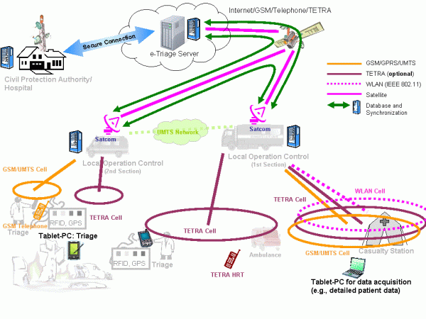
The different terrestrial wireless technologies supported by an OSECE are depicted in Figure 4. Note that two or more OSECEs connected via WLAN in bridged mode can be deployed in the field with only one having backhaul connectivity.

Figure 4: Fully deployed e-Triage communication infrastructure.
Conclusion
This paper has given a brief description of the architecture of the e-Triage system and the challenge to manage data in MCIs. Although earlier and other current works have studied single components of electronic MCI management, a unique feature of e-Triage is that for the first time a coherent overall concept consisting of mobile devices, communication infrastructure, and data management is under development. Another unique feature is that all developments, ranging from hardware selection to graphical user interface implementation, are accompanied by a team of psychologists, ensuring that all components are self-explanatory and can be used intuitively without causing additional stress. At the time of writing this article the system is under implementation and a series of real-live trials will start from January 2011.
Public safety communication means in most cases voice communication (group calls) using dedicated PMR networks, which are designed for closed user groups with partly specific confidentiality requirements. Introducing data communication to public safety requires appropriate preparation, which means that one may not rely on the availability of public (commercial) terrestrial networks only. With our satellite-based communication facilities flexible data services can be provided plus the possibility to quickly establish point-to-point telephone services in case of extreme disasters. It is important to remark that even without a backhaul link all the services provided in the disaster area are available, so that the rescue operation will not be affected
References
- B. Wisner and J. Adams, Eds., Environmental health in emergencies and disasters: a practical guide. World Health Organisation (WHO), Jul. 2003. [Online]. Available: http://www.who.int/water_sanitation_health/hygiene/emergencies/emergencies2002/en/
- S. Nestler, M. Huber, and G. Klinker, “Hybrid approach for management of patient-related information in mass casualty incidents,” Technische Universität München, Technical Report, Oct. 2009, TUMI0926. [Online]. Available: http://ar.in.tum.de/Chair/PublicationDetail?pub=nestler2009hybrid
- T. Massey, T. Gao, M. Welsh, J. H. Sharp, and M. Sarrafzadeh, “The design of a decentralized electronic triage system,” in American Medical Informatics Association (AMIA) Annual Symposium Proceedings, 2006, pp. 544–548, PMCID: PMC1839501. [Online]. Available: http://www.ncbi.nlm.nih.gov/pmc/articles/PMC1839472/pdf/AMIA2006_0429.pdf
- T. Gao and D. White, “A next generation electronic triage to aid mass casualty emergency medical response,” in Proceedings 28th Annual International Conference IEEE Engineering in Medicine and Biology Society (EBMS), New York City, USA, Aug./Sep. 2006.
- S. Inoue, A. Sonoda, and H. Yasuura, “Triage with RFID tags for massive in-cidents,” in RFID Handbook: Applications, Technology, Security, and Privacy, S. A. Ahson and M. Ilyas, Eds. CRC Press, Mar. 2008, ch. 27, pp. 329–349.
- A. Donner, C. Adler, M. Ben-Amar, and M. Werner, “IT-supported manage-ment of mass casualty incidents: The e-Triage project,” in Proceedings 5th Future Security Research Conference, Berlin, Germany, Sep. 2010.
- C. Tang, A. Donner, J. M. Chaves, and M. Muhammad, “Performance of database synchronization via satellite,” in Proceedings 5th Advanced Satellite Multimedia Systems (ASMS) Conference and 11th Signal Processing for Space Communications (SPSC) Workshop, Cagliari, Sardinia, Italy, Sep. 2010, pp. 455–461.
- E. H. Fazli, M. Werner, N. Courville, M. Berioli, and V. Boussemart, “Integrated GSM/WiFi backhauling over satellite: Flexible solution for emergency communications,” in Proceedings 67th Vehicular Technology Conference (VTC2008-Spring). Singapore: IEEE, May 2008, pp. 2962–2966.
- À. V. Estrem and M. Werner, “Portable satellite backhauling solution for emergency communications,” in Proceedings 5th Advanced Satellite Multimedia Systems (ASMS) Conference and 11th Signal Processing for Space Communications (SPSC) Workshop, Cagliari, Sardinia, Italy, Sep. 2010, pp. 262–269.
