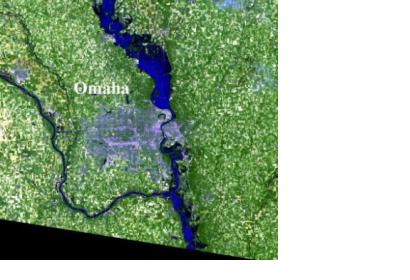
Landsat 5 captured an image of flooding occurring along the Iowa/Nebraska border on June 30, 2011. Flooding is still occurring on July 6, and Flood Warnings are still in effect from the National Weather Service.
The Landsat 5 image captured was an enlargement of the area just north of Omaha. The flood waters show up as very dark blue and, where the water is shallow, medium blue. In the image, the Interstate is cut off by flood waters, just south of Missouri Valley, Iowa, and about 20 miles north of Omaha.
According to Omaha.com, officials from federal, state and local agencies will begin damage assessments from the flooding in the six Iowa counties that line the Missouri River. WOWT-TV reported on July 6 that part of U.S. Highway 30 from Blair to I-29 will be closed today, July 6, until the morning of July 8. The Iowa Department of Transportation closed the road to install a flood barrier.
On July 6, 2011 at 9:39 a.m. CDT, the National Weather Service posted several flood warnings. Flood warnings are in effect for: The Missouri River at Decatur affecting Monona, Burt and Thurston Counties; Missouri River near Blair affecting Harrison and Washington Counties; The Missouri River at Omaha affecting Pottawattamie, Douglas and Sarpy Counties; The Missouri River at Plattsmouth affecting Mills and Cass Counties; the Missouri River at Nebraska City affecting Fremont and Otoe Counties; the Missouri River at Brownville affecting Atchison and Nemaha Counties; and the Missouri River at Rulo affecting Holt and Richardson Counties.
The Landsat Program is a series of Earth-observing satellite missions jointly managed by NASA and the U.S. Geological Survey. Landsat satellites have been consistently gathering data about our planet since 1972. They continue to improve and expand this unparalleled record of Earth's changing landscapes, for the benefit of all. The next Landsat is scheduled to launch in December 2012.

