  • English
  • Español
  • Français

United
Nations


Office for Outer Space Affairs
UN-SPIDER Knowledge Portal

  • Accueil
  • À propos
    • Qu'est-ce que l'ONU-SPIDER?
    • À propos d’UNOOSA
    • Publications
    • Offres d'emploi
    • Rencontrez l'équipe
    • Contact
  • Applications spatiales
    • Technologie satellitaire
    • Mécanismes d’urgence
    • Recovery Mechanisms
    • Réseau international d'alerte aux astéroïdes
    • Space Mission Planning Advisory Group
    • Initiative internationale sur la météorologie spatiale
    • Les technologies spatiales à l'ONU
    • Comptes-rendus d'utilisateurs
  • Liens & ressources
    • Application de données du mois
      • Disaster Recovery
    • Sources de données
    • SIG et logiciels de télédétection
    • Online Learning Resources
    • Institutions
  • Risques & catastrophes
    • Prévention des risques de catastrophe
    • Systèmes d'alerte précoce
    • Gestion des catastrophes et des interventions d'urgence
    • Aléas naturels
    • Cadre d'action de Sendai
    • L'ONU et la prévention des risques de catastrophe
    • L'ONU et les alertes précoces
    • L'ONU et la gestion des catastrophes
  • Appui technique
    • Missions Conseil
    • Appui d’urgence
    • Appui à distance
    • Pratiques recommandées
    • Activités de formation
    • Utilisations pratiques
  • Réseaux
    • Bureaux régionaux d’appui
    • GP-STAR
    • MHEWS
    • IWG-SEM
  • Projets
    • SPEAR
    • SEWS-D
    • EvIDENz
    • Flood GUIDE
  • Actualités
    • Actualités
    • Événements
    • Événements passés
  • Admin
    • SAM Items

Breadcrumb

  • Home
  • Using NASA Earth Observations To Evaluate The Relationship Between Land Use/Land Cover And Tornadogenesis In Alabama
  • Using NASA Earth Observations to Evaluate the Relationship Between Land Use/Land Cover and Tornadogenesis in Alabama

Using NASA Earth Observations to Evaluate the Relationship Between Land Use/Land Cover and Tornadogenesis in Alabama

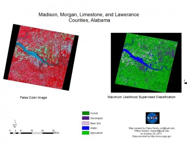
The April 27, 2011, tornado outbreak was the second-deadliest in U.S. history, and the deadliest since the Doppler Radar system has been used to warn communities. Alabama has been involved in six of the 10 deadliest tornado outbreaks in U.S. history. Studies on tornadogenesis and tornado paths have found that the occurrence of tornadoes within Tornado Alley is not entirely random and that environmental factors may contribute to where tornadoes may form and what direction they may travel. Terrestrial environmental parameters such as land use/land cover, vegetation, soil profiles, topography and other surface features need to be explored for their role in the development of tornadoes. This information is crucial for disaster management. NASA EOS can provide historical data on environmental parameters and tornadoes to study these associations retrospectively. In the current project, we propose to use remotely sensed data from Landsat and ASTER satellites to evaluate the association between terrestrial environmental parameters and the occurrence of tornadoes in Alabama between 1974 and 2011. Based on the results of our analysis, we will expand this project to examine the role of other factors, including meteorological variables, in tornadogenesis. Findings will be used for outreach activities in the general community including the academic and service sectors.

For more information you can find the poster presentation under the source link

earthzine
Thu, 10 Nov 2011 - 09:07

Footer menu

  • Contact
  • Terms of Use

User account menu

  • Log in