United
Nations
Office for Outer Space Affairs
UN-SPIDER Knowledge Portal
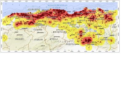
The maps requested via the International Charter: Space and Major Disasters regarding the wildfires that ravaged north Algerian forests during summer 2012, are now available on the Charter's website.
An estimated 20,000 hectares of land have been ravaged by forest fires in the north of Algeria since June. These are a result of hotter than average summer heat waves that have been reported to reach as high as 50 degrees Celsius.
The maps produced by UNITAR/UNOSAT represent density of fire events in North Algeria between 1 June and 23 August 2012 and fire scars as of 18 August 2012. They are accompanied by graphs representing a complete history of MODIS fire detections from an aggregate of the Charter area of interest, summarized by daily total fire detections during 1 January 2000 - 23 August 2012.
