United
Nations
Office for Outer Space Affairs
UN-SPIDER Knowledge Portal
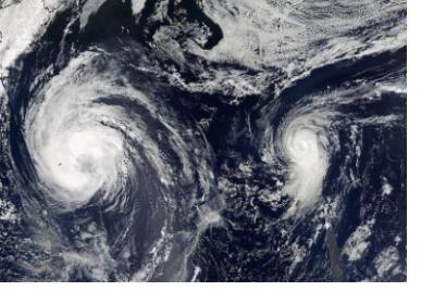
Satellite images from two NASA satellites were combined to create a full picture of Tropical Storm Leslie and Hurricane Michael spinning in the Atlantic Ocean. Imagery from Aqua and Terra satellites showed Leslie now past Bermuda and Michael in the north central Atlantic, and Leslie is much larger than the smaller, more powerful Michael. Images of each storm were taken by the Moderate Resolution Imaging Spectroradiometer (MODIS) instrument that flies onboard both the Aqua and Terra satellites. Both satellites captured images of both storms on Sept. 7 and Sept. 10. The image from Sept. 7 showed a much more compact Michael with a visible eye. By Sept. 10, the eye was no longer visible in Michael and the storm appeared more elongated from south to north. Satellite imagery showed also that another tropical depression may be forming in the eastern Atlantic.
